Bertha Peak via Polique Canyon Road Hike
View Photos
Bertha Peak via Polique Canyon Road Hike
Difficulty Rating:
The Bertha Peak via Polique Canyon Road Hike is an easy-going adventure in the San Bernardino Mountains that will take you to a summit viewpoint overlooking the surrounding landscape. While out hiking the trail, you will traverse a small stretch of the Pacific Crest Trail, before working along a dirt road to reach the summit of Bertha Peak. If you are after a quick hike that offers maximum views for a minimal effort, then this is the route for you.
Getting there
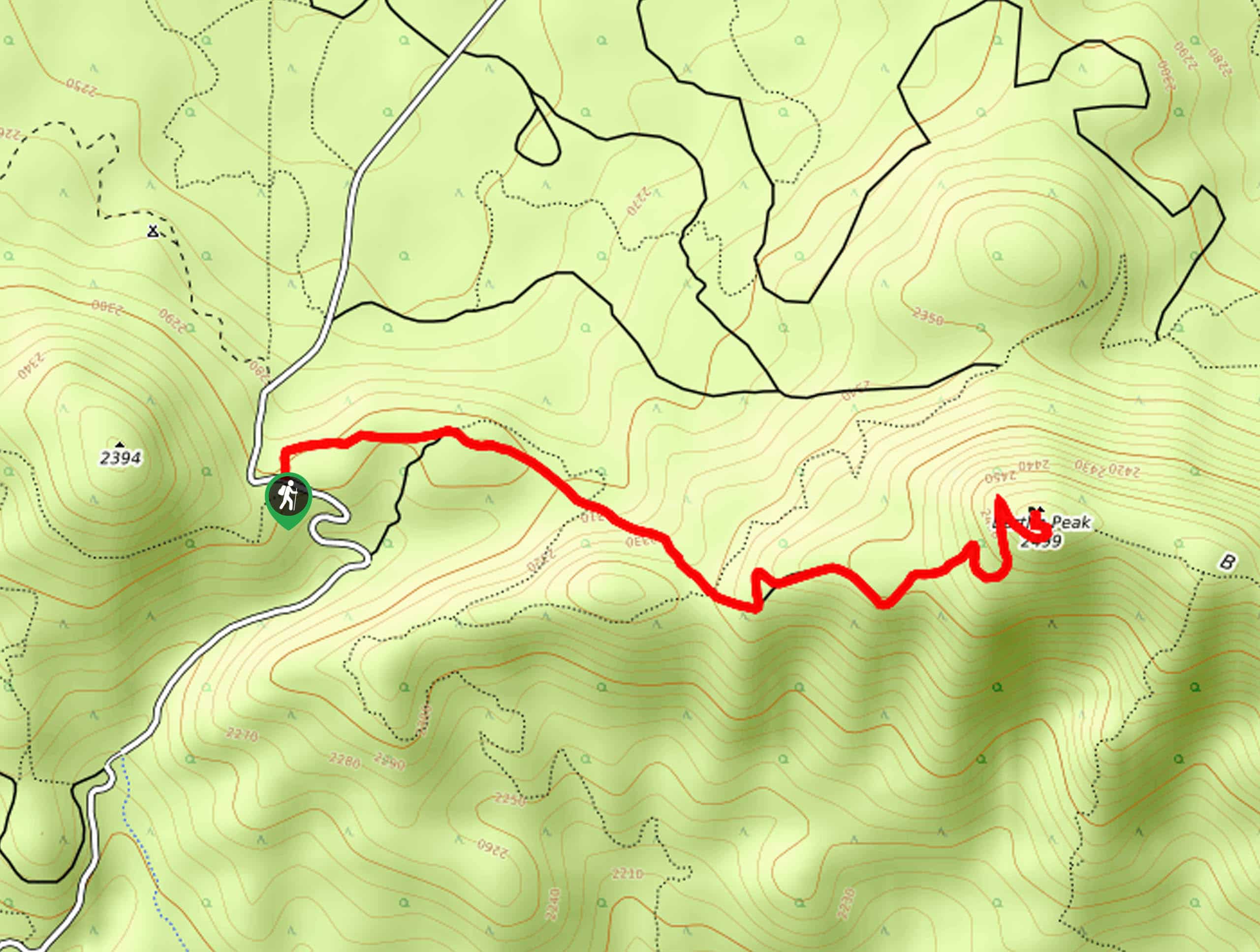
The starting point for the Bertha Peak via Polique Canyon Road Hike can be found along Polique Canyon Road at the Pacific Crest Trail-Polique Canyon Trailhead.

About
| Backcountry Campground | No |
| When to do | Year-Round |
| Pets allowed | Yes |
| Family friendly | Yes |
| Route Signage | Average |
| Crowd Levels | Moderate |
| Route Type | Out and back |
Bertha Peak via Polique Canyon Road Hike
Elevation Graph
Weather
Bertha Peak via Polique Canyon Road Hike Description
If you are in the San Bernardino area and want to set out on a fairly laidback hiking adventure with little in the way of challenging terrain, but will still impress with gorgeous mountain views, then you will certainly want to check out the Bertha Peak via Polique Canyon Road Hike.
Setting out from the trailhead on Polique Canyon Road, you will head to the east through the forest along a small stretch of the Pacific Crest Trail. Here, you will steadily gain elevation through the tree cover, before arriving at a junction with a forest service road.
Continuing along the road to the southeast, you will work your way further uphill while enjoying beautifully scenic views of the San Bernardino Mountains, before eventually arriving at the summit of Bertha Peak. Take some time here to soak up the views, before heading back along the same route to return to the trailhead where you began. If you are looking to extend your hike or simply take a longer journey through the area, then check out the nearby Cougar Crest Trail for more of the same Southern California views.
Similar hikes to the Bertha Peak via Polique Canyon Road Hike hike

Bluff Mesa Hike
The Bluff Mesa Hike is a fantastic adventure in Southern California that features a lovely woodland setting and can be…

Palm View Peak Trail
The Palm View Peak Trail is a great hiking route in the San Bernardino National Forest that features a solid…

Cram Peak Ridge Trail
The Cram Peak Ridge Trail is a fantastic, albeit difficult, hiking route in the San Bernardino National Forest that will…
Comments