
Desolation Ridge Trail
View Photos
Desolation Ridge Trail
Difficulty Rating:
The Desolation Ridge Trail is a challenging route east of Salt Lake City. This trail doesn’t get much traffic, so it’s a great place to go if you are looking for some peace and quiet. The Desolation Ridge Trail winds through the beautiful Uinta-Wasatch-Cache National Forest. Try this trail in the fall when vibrant autumn leaves ignite the forest.
Getting there
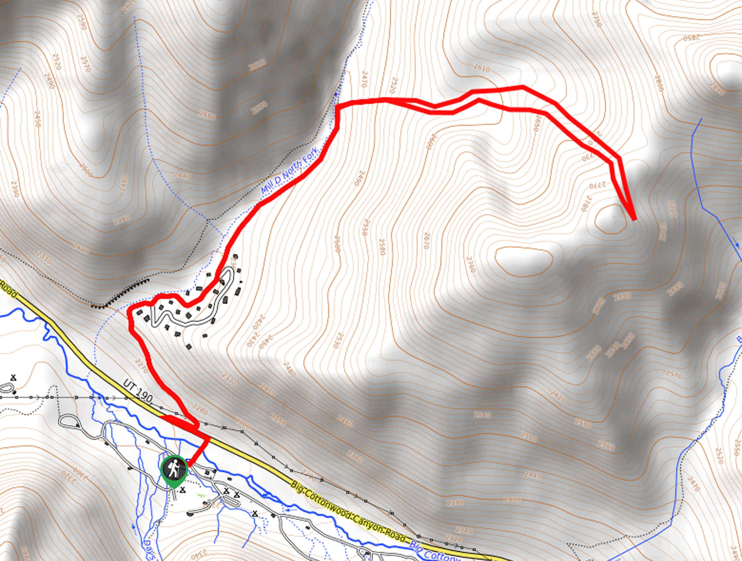
This hike begins at the Spruces Campground on Highway 190/Big Cottonwood Canyon Road in between Salt Lake City and Park City, Utah.

About
| Backcountry Campground | Spruces Campground at Trailhead |
| When to do | Year-round |
| Pets allowed | No |
| Family friendly | No |
| Route Signage | Poor |
| Crowd Levels | Low |
| Route Type | Lollipop |
Desolation Ridge Trail
Elevation Graph
Weather
Desolation Ridge Trail Description
The Desolation Ridge Trail is a challenging hike in Big Cottonwood Canyon east of Salt Lake City, Utah. This trail is a consistently steep ascent; hikers should be prepared with proper hiking footwear and plenty of water. We recommend bringing along a set of hiking poles to aid in your ascent and save your knees some strain on the way back down. This hike begins and ends at the lovely Spruces Campground. If you are spending a few nights enjoying the campground, The Desolation Ridge Trail is a great way to get out and explore your surroundings with a morning or afternoon hike.
Beginning at the Spruces Campground, cross over Big Cottonwood Canyon Road and follow Canyon Spruce Road to the Mill D North Fork. Continue following the creek northeast for about a mile before branching off and following the switchbacks eastward to a summit point.
Take a rest at the top and enjoy the views before turning around and heading back to the Mill D North Fork. From the creek, simply follow your footsteps back to the Spruces Campground where you began.
Similar hikes to the Desolation Ridge Trail hike

Willow Hollow, Ridge, and Pine Hollow Trail
The Willow Hollow and Pine Hollow Trail is a beautiful route in the Uinta-Wasatch-Cache National Forest. This trail is an…

Solitude to Beaver Pond Trail
The Solitude to Beaver Ponds Trail is a beautiful hike through the Uinta-Wasatch-Cache National Forest. This trail is lush and…

City Creek Canyon Road
The City Creek Canyon Road is a popular trail just north of downtown Salt Lake City, Utah. This path is…
Comments