
Shadow Mountain Trail
View Photos
Shadow Mountain Trail
Difficulty Rating:
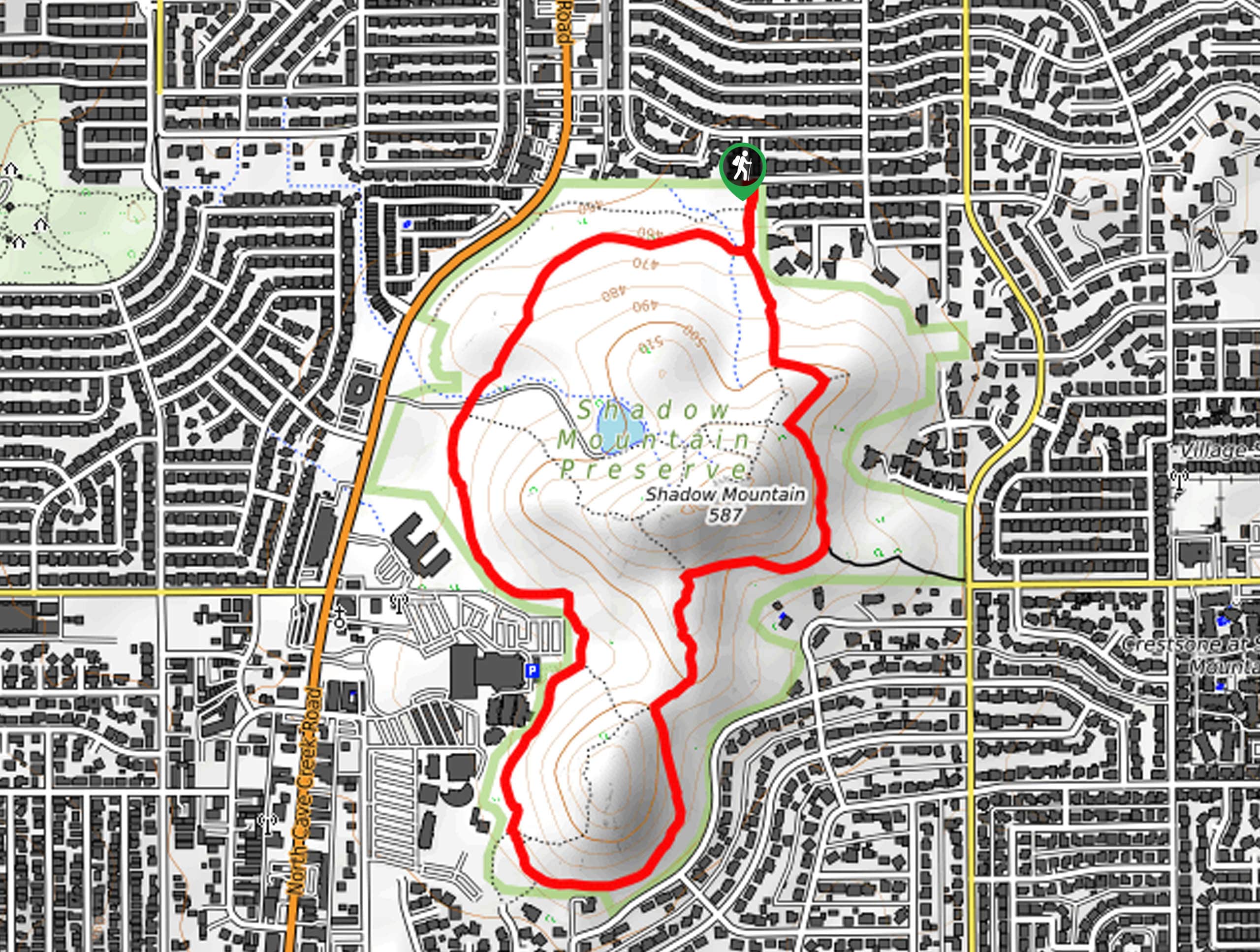
The Shadow Mountain Trail leads you around the portion of the Phoenix Mountain Preserve that Shadow Mountain is in. This small park is easy to get to in the city, the views are natural, and the somewhat primitive trails make you feel like you’re not still right in Phoenix. Choose this one for a quick adventure with family or the dogs.
Getting there
The trailhead for this hike is on E Acoma Drive.

About
| Backcountry Campground | No |
| When to do | October-May |
| Pets allowed | Yes - On Leash |
| Family friendly | Yes |
| Route Signage | Poor |
| Crowd Levels | High |
| Route Type | Loop |
Shadow Mountain Trail
Elevation Graph
Weather
Shadow Mountain Trail Description
This hike is a short and sweet loop around Shadow Mountain. This route is easy to get to in the city, so pick it when you need some fresh air but you can’t go very far. The route is kid-friendly and dog-friendly on leash. You can easily add on a quick ascent of Shadow Mountain if you’d like.
This route is a bit primitive. It’s not well-marked or always very well-maintained. Bring a GPS track to help stay on the trail if you haven’t explored this area before. Bring water with you and avoid hiking in the heat of the day.
From the trailhead, take a few steps south to the fork. Our route goes clockwise, so stay left to head towards Shadow Mountain. Head along its eastern base (you can make a quick run up to the summit from the fork of the trail). At the next fork, stay right, then stay left at the fork that follows.
Stay left at the next fork to loop around the far bottom edge of the park. The trail will turn north again and follow the edge of the park back to the trailhead.
Similar hikes to the Shadow Mountain Trail hike

Palisade to Basalt Loop
The Palisade to Basalt Loop is a short, easy trail in the Deem Hills Recreation Area. This hike is 1.4mi

Two Bit and Rattle Saddle Loop
The Two Bit and Rattle Saddle Trail is a moderately challenging hike in the Phoenix’s Mountain Preserve near Piestewa Peak.…

Ma-Ha-Tauk and Crosscut Loop
The Ma-Ha-Tauk and Crosscut Loop is a moderate hike in Phoenix’s South Mountain Preserve. With pleasant views and not much…
Comments