
Keyhole Hot Springs Hike
View Photos
Keyhole Hot Springs Hike
Difficulty Rating:
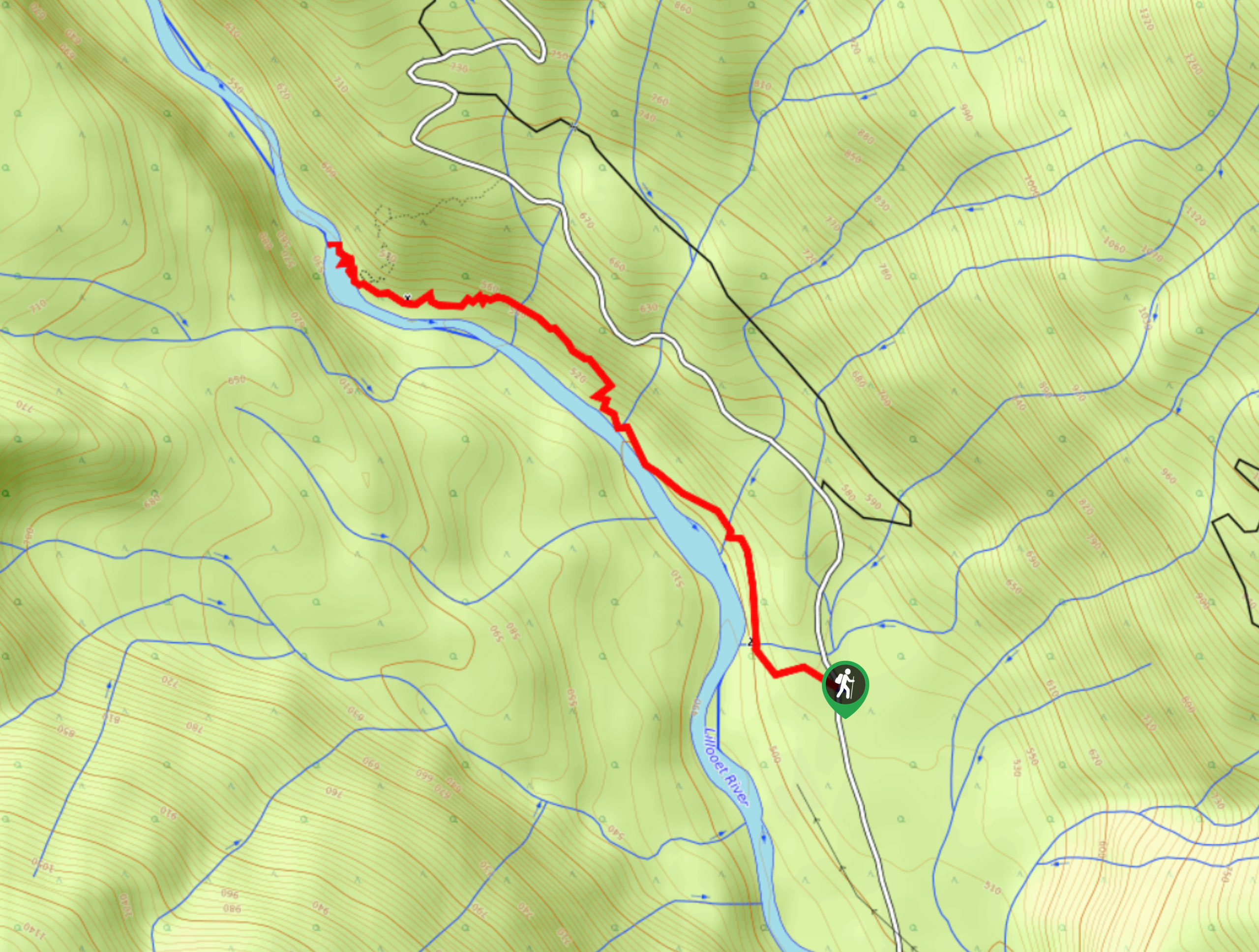
The hike to the Keyhole Hot Springs is a 2.4mi out-and-back route along the banks of the Lillooet River that takes hikers through a scenic stretch of forest on the way to the relaxing thermal pools. Pass through forests of massive cedar trees and cross over the rushing water of nearby streams to reward yourself with a soak in the picturesque springs. Make sure to set out on the hike early, or else you might not be able to find a spot when you arrive!
Getting there
To get to the trailhead for the Keyhole Hot Springs from Pemberton, head north on Pemberton Meadows Road for 14.5mi and turn right onto Lillooet Forest Service Road. In 0.9mi, make a left turn to keep on Lillooet FSR and continue on for 4.6mi. Here, make another left to stay on the same road, keeping on it for 20.8mi to reach the parking area.

About
| When to do | December-March |
| Backcountry Campsites | Meager Creek |
| Pets allowed | Yes |
| Family friendly | Older Children only |
| Route Signage | Average |
| Crowd Levels | Moderate |
| Route Type | Out and back |
Keyhole Hot Springs Hike
Elevation Graph
Weather
Keyhole Hot Springs Trail Description:
Keyhole Hot Springs has become an increasingly popular spot over the last few years due to its picturesque setting and relaxing pools of water, and it is this popularity that has provided some benefits and several drawbacks for the area. Firstly, the remote location of the trail northwest of Pemberton has become more accessible, as the service roads used to get there are better maintained due to the influx of visitors. Unfortunately, these visitors and their poor camping practices – especially in terms of food and waste management – have caused local grizzly bear populations to move into the area, greatly increasing the frequency of their interactions with humans. As a result, officials have decided to close the hot springs annually from April to mid-November in an effort to rehabilitate the local bear population.
The remote nature of the trail and the fact that you can only use it in the winter/early spring makes the logistics of reaching the trailhead into a bit of an issue. Make sure that your vehicle can handle the rugged roads before setting out on your trip. Additionally, the trail itself has some steep sections, so don’t be fooled by the short length of the hike. Make sure to wear proper hiking footwear and bring crampons or microspikes to safely traverse any snowy/icy trail conditions.
If you can manage to plan a visit for when the Keyhole Hot Springs and the trail are open, you will be rewarded with some beautiful backcountry scenery, as well as the opportunity to soak in the steaming waters of the thermal pools. The trail contains several stream crossings and skirts closely alongside the milky-blue waters of the Lillooet River before arriving at the hot springs themselves. Here, you will be able to soak in the hot pools as you take in the beautiful riverside landscape. This hike may be a short one, but that just leaves you extra time to enjoy the natural spa-like waters of the Keyhole Hot Springs.
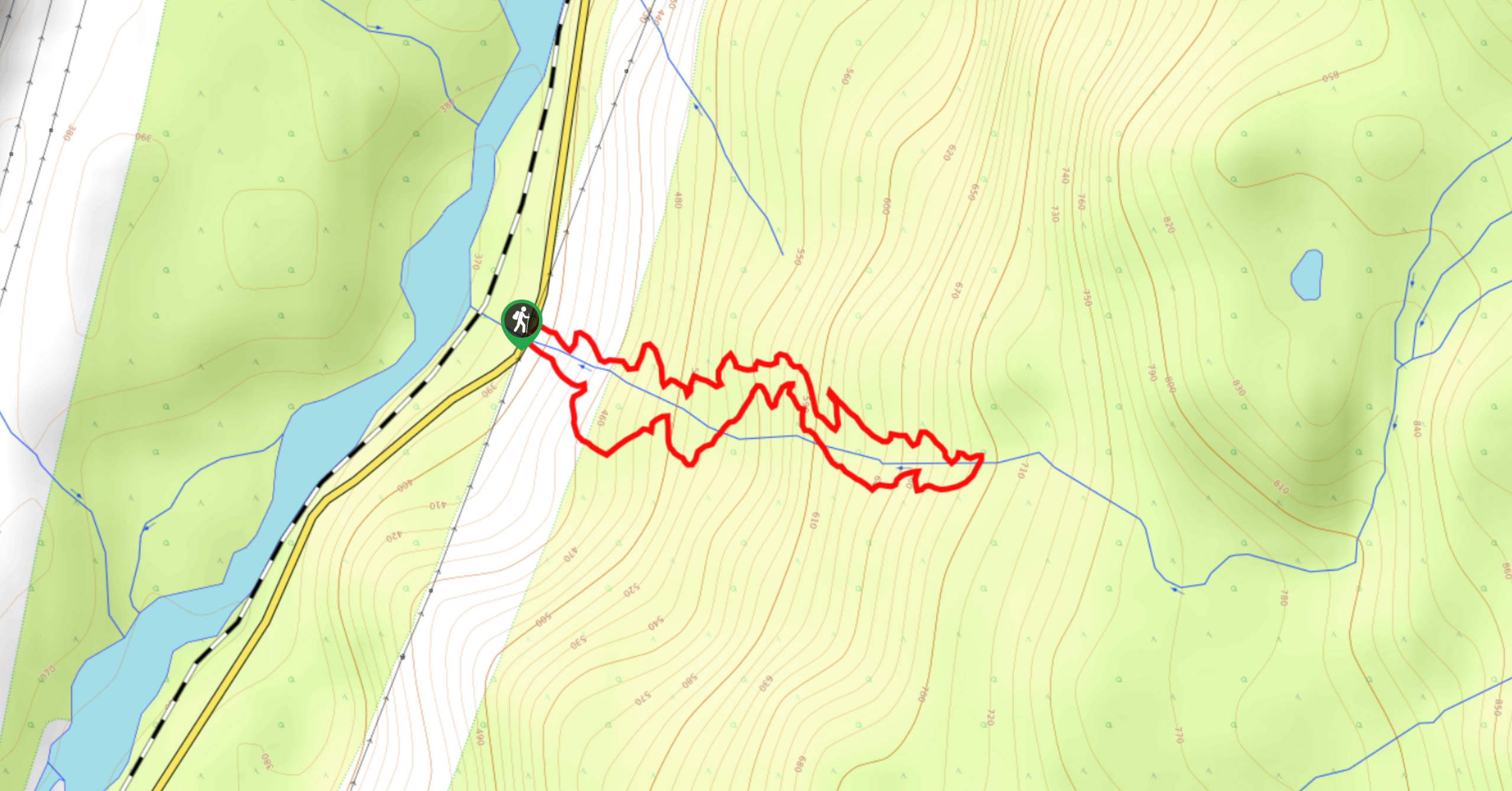
Setting out from the parking area off Lillooet FSR, make your way west along the trail marked with tape and reflectors as it heads towards the rushing waters of the river. Head through the forest of massive cedar trees and cross over the creek, following the trail north as it skirts alongside the river. Here, you will pass through a boulder field and cross over several creeks while taking in the fleeting views of the surrounding mountains. Make your way over the bridge spanning “Truckwash River”, before meeting up with another trail just short of the Keyhole Hot Springs.
Pass by the trail and continue along the water’s edge to find the tiered pools of the hot springs nestled against the coursing waters of the river. Spend the afternoon soaking in the thermal waters as you take in the picturesque views and likely meet a few new friends. When you have had enough of the Keyhole Hot Springs, dry off and make your way back along the same path to return to the parking area.
Hiking Route Highlights
Keyhole Hot Springs
Named after nearby Keyhole Falls that were formed by the volcanic activity of Mount Meager nearly 2400 years ago, the Keyhole Hot Springs are a series of thermal pools that can be found along the banks of the Lillooet River. The eruption of Mount Meager was the most recent major volcanic activity in Canada within the past 10,000 years, spreading ash as far away as Alberta.
Insider Hints
This trail is closed from April to mid-November every year.
Wear proper hiking footwear, as the trail does have some steep sections.
Bring additional equipment like crampons or microspikes to traverse the winter trail conditions.
Remember to take any food or waste back out with you, as bears in the area are becoming accustomed to human interaction.
Similar hikes to the Keyhole Hot Springs Hike hike
Cool Creek Canyon Hike
The Cool Creek Canyon Hike is a 1.3mi loop route near Pemberton that features spectacular mountain views and…
One Mile Lake Trail
Hiking around One Mile Lake will take you on a 4.3mi trek through the woodlands south of Pemberton.…
Hike to Rohr Lake
The hike to Rohr Lake is a fun 5.3mi out-and-back trail that traverses a variety of terrain, including…
Comments