
Dove Crag and Simonside via Lordenshaws Car Park
View Photos
Dove Crag and Simonside via Lordenshaws Car Park
Difficulty Rating:
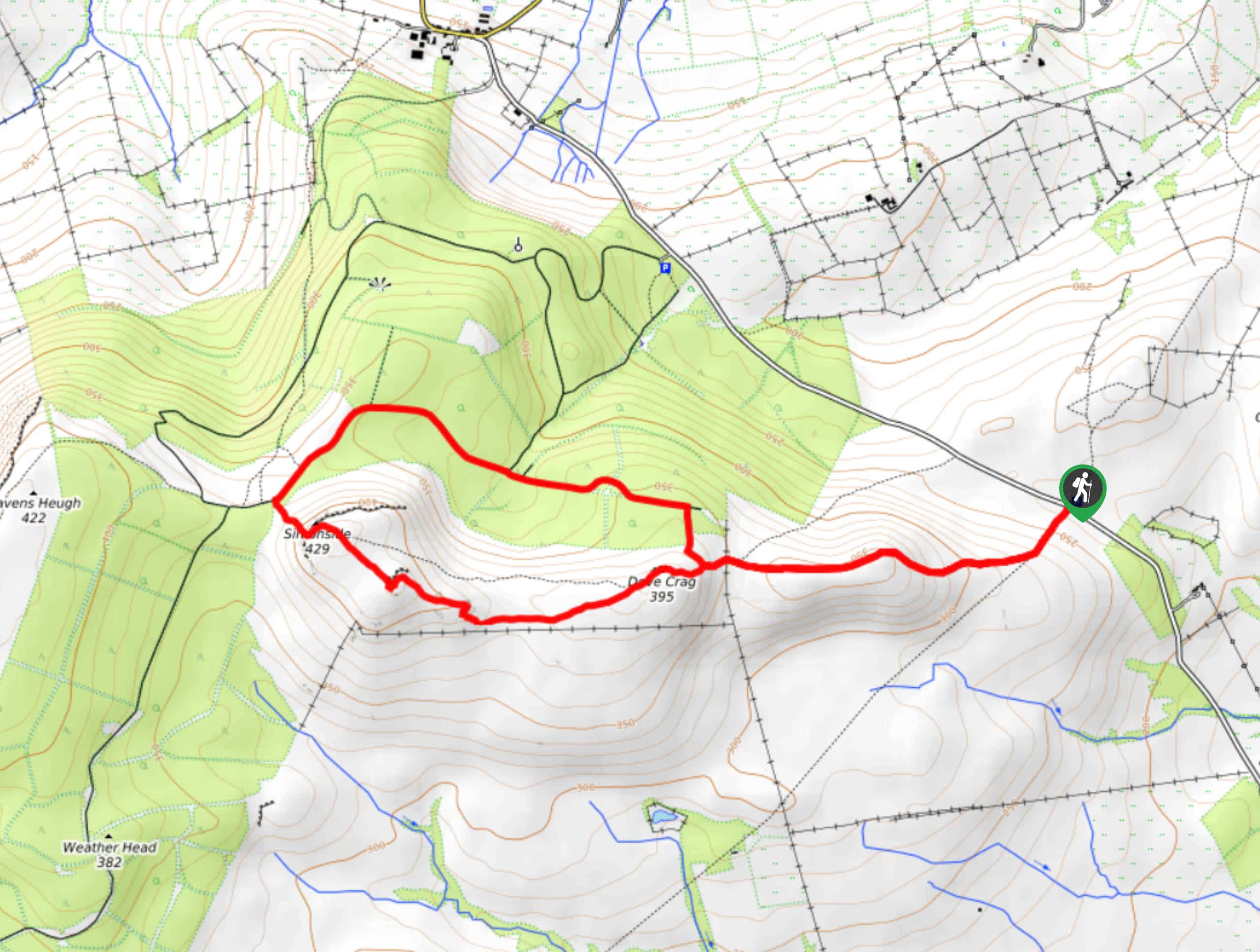
The walk to Dove Crag and Simonside via Lordenshaws Car Park is a fun and easy to navigate adventure in Northumberland that features a variety of terrain and scenic views. While out walking the trail, you will climb uphill across the moor to traverse the hilltop summits of Dove Crag and Simonside, before looping around on the return leg. Although there is a bit of elevation gain, the well laid out path makes this walk perfectly suited for beginners or families.
Getting there
The Dove Crag and Simonside via Lordenshaws Car Park trailhead can be found 3.8mi south of Rothbury at the Simonside Ridge car park.

About
| Backcountry Campground | No |
| When to do | Year-Round |
| Pets allowed | Yes - On Leash |
| Family friendly | Yes |
| Route Signage | Average |
| Crowd Levels | Moderate |
| Route Type | Lollipop |
Dove Crag and Simonside via Lordenshaws Car Park
Elevation Graph
Weather
Dove Crag and Simonside via Lordenshaws Car Park Description
Featuring lovely views of the surrounding Northumberland landscape, some rugged moorland terrain, and a bit of elevation gain to get your heartrate up, the walk to Dove Crag and Simonside via Lordenshaws Car Park is an excellent adventure worth undertaking.
Setting out from the car park, you will head to the southwest across the road to pick up the footpath, making sure to bear right at the fork to begin climbing up the ridge. Here, you will work your way across the moor to reach the top of Dove Crag.
After taking in the views, continue on to the northwest across the undulating terrain to reach the summit of Simonside, where you will enjoy some more pleasant views of the surrounding forests, moors, and grasslands. Heading downhill, the trail will bend back towards the east along the edge of the forest, once again traversing the moor on the way back to the car park where you started your walk.
Similar hikes to the Dove Crag and Simonside via Lordenshaws Car Park hike

Hadrian’s Wall: Steel Rigg to Lanercost
Walking Hadrian’s Wall: Steel Rigg to lanercost is a fantastic - albeit lengthy - adventure that will lead you across…

Hadrian’s Wall: Wallsend to Heddon on the Wall
Hadrian’s Wall: Wallsend to Heddon on the Wall is the first section of the long distance Hadrian’s Wall Path walking…

Scotch Gill Woods Walk
The Scotch Gill Woods Walk is a short and easy-going adventure in Morpeth, Northumberland that will take you through a…
Comments