
Saltergate to Pickering Walk
View Photos
Saltergate to Pickering Walk
Difficulty Rating:
The Saltergate to Pickering Walk is a great long distance walking route in the North York Moors that isn’t overly difficult, making it a lengthy but fun day on the trails. While out walking this route, you will pass by the Bridestones and make your way through Levisham before traversing some undulating terrain on the final leg into Pickering. This is a one-way trail, so make sure to arrange a pick up at the end point of the walk so that you can get back to your vehicle.
Getting there
To reach the trailhead for the Saltergate to Pickering Walk from Pickering, head north on Kirkham Lane/A169 for 7.5mi and turn right to enter the car park.

About
| Backcountry Campground | No |
| When to do | Year-Round |
| Pets allowed | Yes - On Leash |
| Family friendly | No |
| Route Signage | Average |
| Crowd Levels | Low |
| Route Type | One Way |
Saltergate to Pickering Walk
Elevation Graph
Weather
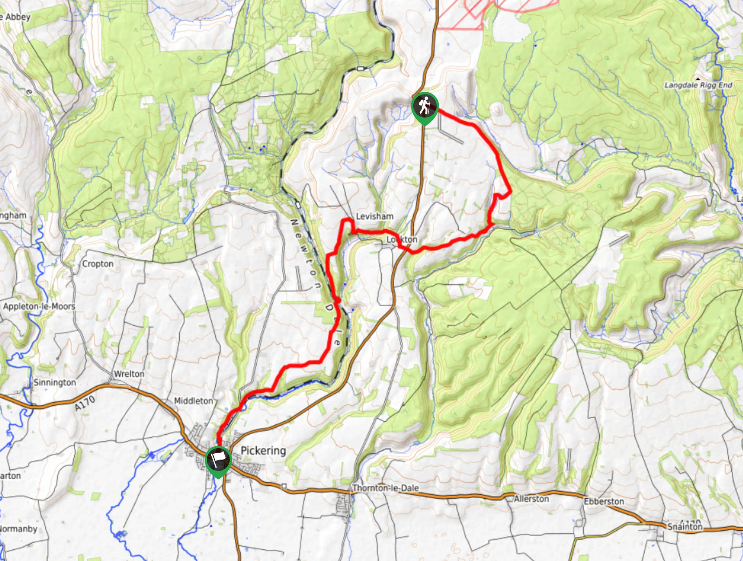
Saltergate to Pickering Walk Description
Featuring relatively laid back terrain throughout the route, the Saltergate to Pickering Walk is a long distance trail that will give you a full day of outdoor exploration without wearing you out completely. There is a moderate amount of elevation gain spread across the walk; however, there are only a few brief sections that could be deemed as being somewhat steep. In any case, this beautifully scenic trail will allow you to experience the wonderful landscapes that can be found towards the south end of the North York Moors.
Setting out from the car park, you will head to the southeast across the open fields, eventually walking along the edge of a steep hillside until you reach the Bridestones, a series of weathered sandstone pillars surrounded by beautiful forests. From here, you will turn to the southwest and cross over Whitby Road and Levisham Beck, climbing uphill to pass through the charming village of Levisham.
Turning to the south, you will traverse the peaceful expanse of Levisham Wood and head downhill through a valley, before climbing uphill on the opposite side. Traversing the open countryside to the southwest, you will make the final approach into Pickering, passing by the historic Pickering Castle on the way into the trail’s end.
Similar hikes to the Saltergate to Pickering Walk hike

Kirkbymoorside and Gillamoor Walk
The Kirkbymoorside and Gillamoor Walk is a great outdoor excursion along the southern edge of North York Moors National Park…

Farndale Railway Walk to Blakey Ridge
The Farndale Railway Walk to Blakey Ridge is a lengthy but easy-going route that will allow you to experience the…

Botton and Blakey Ridge Circular Walk
The Botton and Blakey Ridge Circular Walk is a rugged and beautiful adventure that will allow you to experience the…
Comments