Newtondale Halt to Goathland Station Walk
View Photos
Newtondale Halt to Goathland Station Walk
Difficulty Rating:
The Newtondale Halt to Goathland Station Walk is a rugged journey in the North York Moors that will expose you to the beautiful scenery that can be found in the region. While out on the trail, you will climb uphill across the moor and enjoy sweeping views from atop Simon’s Howe before making the descent into Goathland Station. Access to this route can only be achieved by rail, foot, or bike, meaning that you will need to think about your travel arrangements prior to setting out on this adventure.
Getting there
Access to this trailhead is prohibited to vehicles, meaning that you will need to travel by foot, bike, or railway to reach it. If choosing the latter, it can easily be accessed via the NYMR from the Levisham railway station.

About
| Backcountry Campground | Abbots House Farm Campsite |
| When to do | March-November |
| Pets allowed | Yes |
| Family friendly | Older Children only |
| Route Signage | Average |
| Crowd Levels | Low |
| Route Type | One Way |
Newtondale Halt to Goathland Station Walk
Elevation Graph
Weather
Newtondale Halt to Goathland Station Walk Description:
While there are some challenges in traversing the moor along the Newtondale Halt to Goathland Station Walk, the real pain point for this adventure is reaching the trailhead. Located at the Newtondale Halt railway station, you cannot access the trailhead by vehicle, meaning that you will need to travel by foot, bike, or rail to get there. Luckily, the end point for this walk is situated along the same rail line at Goathland Station, meaning you can park your car there, take the train to the trailhead and walk back to your vehicle. There is some rugged terrain throughout this walk, so be sure to wear sturdy boots.
Even with the minor inconveniences in reaching the trailhead, this is a pleasant walk that will challenge you as you traverse the rugged landscape of the moor. From the top of the trail at Simon’s Howe, you will enjoy sweeping views across the North York Moors, making for a fun afternoon out on the trails.
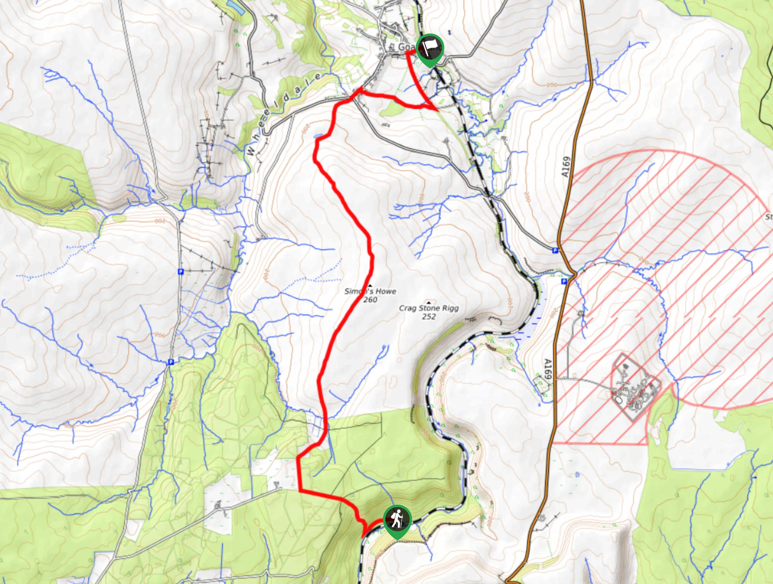
Setting out from the trailhead, you will head to the west along the lane for 0.3mi before turning off to the right to climb up the steep hillside. From here, you will keep straight for 0.4mi to meet up with a road junction, heading straight through it for 0.4mi to pick up another path on the right known as Simon’s Howe Rigg.
Following this path for the next 2.0mi, you will traverse the rugged landscape of the moor and take in the natural beauty of the barren terrain before arriving at the summit of Simon’s Howe. Take some time to enjoy the commanding view presented to you that overlooks the North York Moors before continuing to the north to descend the hillside.
Keeping left for the next 1.4mi, you will arrive at a small body of water known as The Tarn. Head to the right here and continue across the moor until you reach a road junction. Follow the road leading to the northeast for 0.1mi and turn right on the lane, at the end of which, you will find a footpath. Follow this for 0.6mi across the open countryside to meet up with a lane, turning left to make your way through a campground. After 0.5mi, turn right onto the road and follow it east, keeping left at the bend to arrive at the end point of the Newtondale Halt to Goathland Station walk at the railway station.
Insider Hints
Although you cannot travel to the trailhead by car, both the start and end point for this one-way trail are located along a rail line, making for easier travel between the two.
Wear study walking boots to better traverse the rugged terrain throughout this walk.
Toilet facilities can be found at the end point of the route at Goathland Station.
Similar hikes to the Newtondale Halt to Goathland Station Walk hike

Kirkbymoorside and Gillamoor Walk
The Kirkbymoorside and Gillamoor Walk is a great outdoor excursion along the southern edge of North York Moors National Park…

Farndale Railway Walk to Blakey Ridge
The Farndale Railway Walk to Blakey Ridge is a lengthy but easy-going route that will allow you to experience the…

Botton and Blakey Ridge Circular Walk
The Botton and Blakey Ridge Circular Walk is a rugged and beautiful adventure that will allow you to experience the…
Comments