Levisham Station Circular Walk
View Photos
Levisham Station Circular Walk
Difficulty Rating:
Walking the Levisham Station Circular Trail is a lovely adventure in the North Yorkshire countryside that will take you through beautiful terrain to a historical site. While out on the trail, you will cross open fields and climb uphill to reach the Levisham rail station that has origins dating back to 1836 before walking through more forests and fields on the return leg. This wonderfully scenic walk is perfectly suited for a leisurely weekend stroll.
Getting there
To reach the trailhead for the Levisham Station Circular Walk from Pickering, drive north on Kirkham Lane/A169 for 5.2mi and turn left to continue on for 0.3mi. Keep left for 0.2mi and make a right toward Mill Bank Road. After 141ft, make a slight right onto Mill Bank Road and follow it for 0.6mi, continuing straight onto Brygate Lane. After 0.4mi, you will arrive at the parking area.

About
| Backcountry Campground | No |
| When to do | March-November |
| Pets allowed | Yes |
| Family friendly | Yes |
| Route Signage | Average |
| Crowd Levels | Moderate |
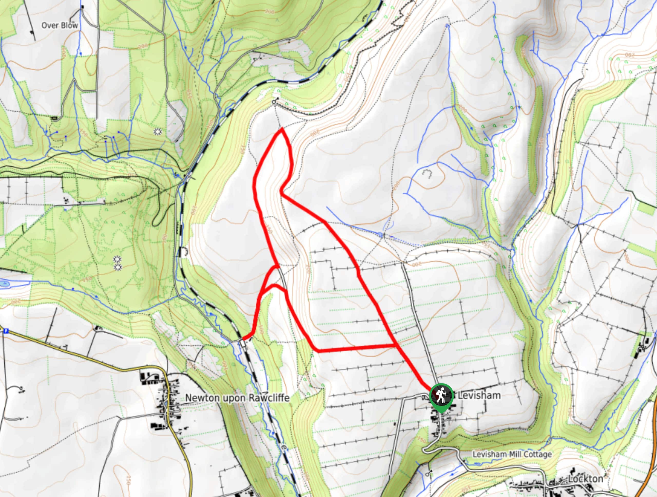
| Route Type | Lollipop |
Levisham Station Circular Walk
Elevation Graph
Weather
Levisham Station Circular Walk Description
Other than a small amount of uphill walking and a few stretches across open fields and moorland, the Levisham Station Circular Walk doesn’t feature anything in the way of rugged terrain. Even still, you should wear some good walking boots for comfort along the trail. Additionally, be sure to keep your dog on a lead to avoid interactions with livestock.
This truly is a beautiful walk in North York Moors National Park, especially if you enjoy mixing scenery with some local railway history! The trail sets out from Levisham and will take you across the open countryside, climbing uphill for some nice views across the surrounding moorland terrain within the park. From here, you will visit the historic Levisham Rail Station before descending the picturesque countryside back to the trailhead. This is a great adventure that the entire family will enjoy.
Setting out from the Horseshoe Inn in Levisham, make your way to the northwest along Braygate Lane for 0.7mi and head through the gate. Keep left through the fork and continue on across the moor for 0.3mi, passing straight through the four-way intersection. Upon reaching a series of junctions after 0.2mi, pass straight through them and climb up the hillside, keeping left until you reach another junction in 0.3mi. Turn left here and follow the path to the southwest for 0.7mi, walking along this elevated hilltop position as you enjoy the sweeping views across the surrounding landscape of north York Moors National Park.
When you meet up with the road, turn right and follow it until you arrive at the Levisham rail station. This historic railway stop dates back to 1836 and was an integral part of Yorkshire’s early rail history. It also features toilet facilities and a place where you can stop in for food and other refreshments. After spending some time here, retrace your steps along the road to the northeast for 0.2mi and pick up the footpath on the right. Keep right to meet up with the road and turn right to follow it downhill for 0.7mi. Here, you will turn right onto Braygate Lane and follow it back into Levisham, where you started the Levisham Station Circular Walk.
Insider Hints
Wear comfortable walking shoes, as there will be some areas with uneven terrain.
Keep your dog on a lead, as livestock will likely be present in the area.
Pop into the refreshment building at the rail station for some mid-walk snacks.
Toilet facilities can also be found at the rail station.
Similar hikes to the Levisham Station Circular Walk hike

Kirkbymoorside and Gillamoor Walk
The Kirkbymoorside and Gillamoor Walk is a great outdoor excursion along the southern edge of North York Moors National Park…

Farndale Railway Walk to Blakey Ridge
The Farndale Railway Walk to Blakey Ridge is a lengthy but easy-going route that will allow you to experience the…

Botton and Blakey Ridge Circular Walk
The Botton and Blakey Ridge Circular Walk is a rugged and beautiful adventure that will allow you to experience the…
Comments