
Drove Road Walk
View Photos
Drove Road Walk
Difficulty Rating:
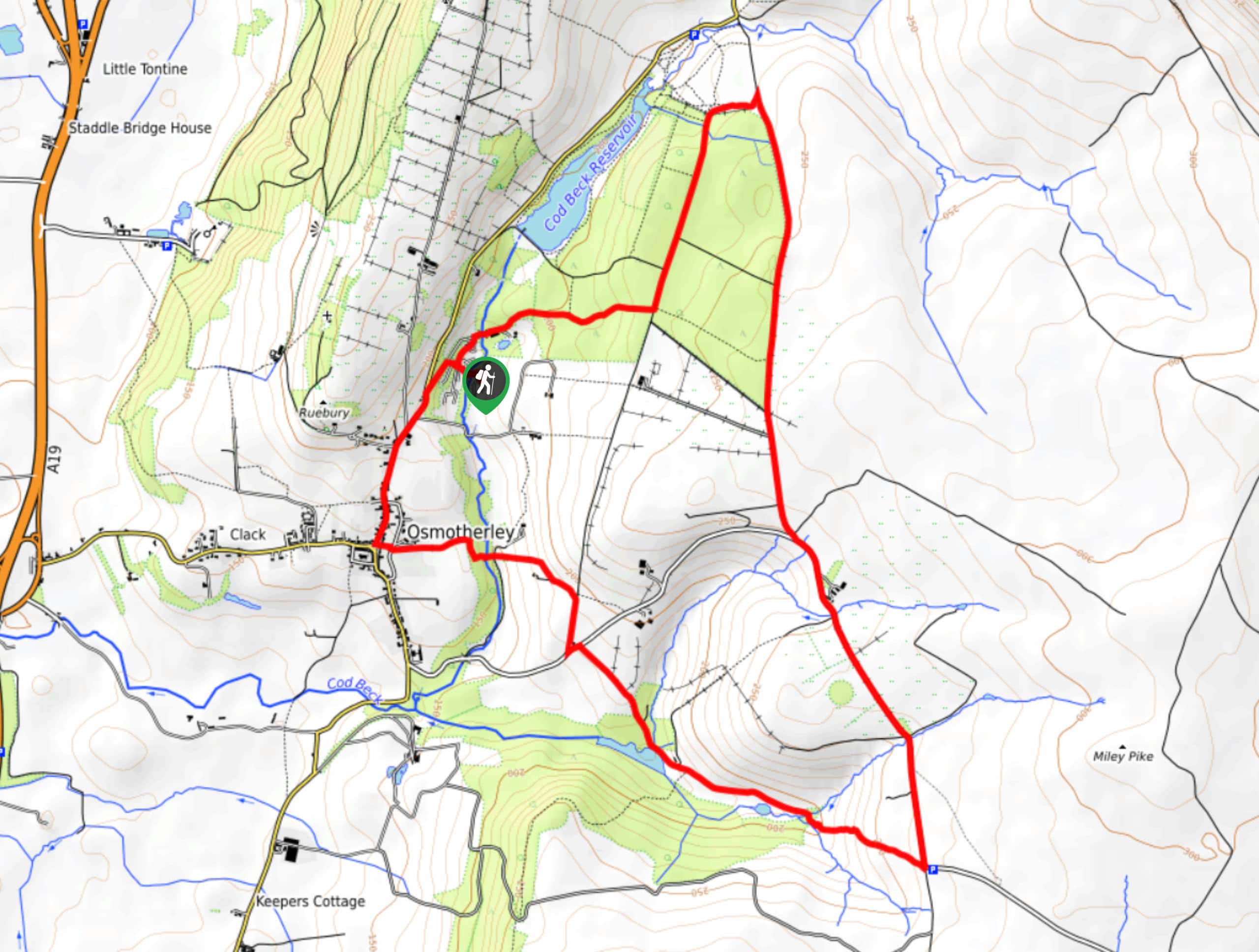
The Drove Road Walk is a fairly laidback adventure in the North York Moors that will see you experience a variety of terrain types and beautiful views of the national park. While out on the trail, you will climb uphill through the forest to reach the moor before turning to the southwest for views of the Oakdale Reservoir. There is a bit of undulating terrain throughout the route, but it is perfectly suitable for beginner and casual walkers.
Getting there
To get to the trailhead for the Drove Road Walk from Osmotherley, head north on N End for 0.3mi and keep straight onto Quarry Lane for another 0.2mi. Make a right to stay on Quarry lane for another 400ft, where you will arrive at the trailhead.

About
| Backcountry Campground | No |
| When to do | March-November |
| Pets allowed | Yes - On Leash |
| Family friendly | Older Children only |
| Route Signage | Average |
| Crowd Levels | Moderate |
| Route Type | Circuit |
Drove Road Walk
Elevation Graph
Weather
Drove Road Walk Description
If you are looking to explore the western edge of the North York Moors and take in the natural beauty of the landscape here, then you will want to experience the Drove Road Walk. Named after an old road along the route that was used by Scottish Cattle Drovers to take their livestock to markets in the south, this fantastic trail also offers some beautiful views of the surrounding landscape.
Setting out from the trailhead, you will make your way through the forests to the northeast and enjoy the peaceful atmosphere of the woodland landscape as you climb uphill to reach the edge of the moor. Once there, you will head to the south and take in the beautiful views of the surrounding landscape, including the barren moor on your right and the calm surface of Oakdale Reservoir to the right. Descending the hillside to the northwest, you will make your way past the reservoir and traverse the undulating landscape, passing through the village of Osmotherley on the return to the trailhead.
Similar hikes to the Drove Road Walk hike

Kirkbymoorside and Gillamoor Walk
The Kirkbymoorside and Gillamoor Walk is a great outdoor excursion along the southern edge of North York Moors National Park…

Farndale Railway Walk to Blakey Ridge
The Farndale Railway Walk to Blakey Ridge is a lengthy but easy-going route that will allow you to experience the…

Botton and Blakey Ridge Circular Walk
The Botton and Blakey Ridge Circular Walk is a rugged and beautiful adventure that will allow you to experience the…
Comments