The Lions via Binkert Trail
View Photos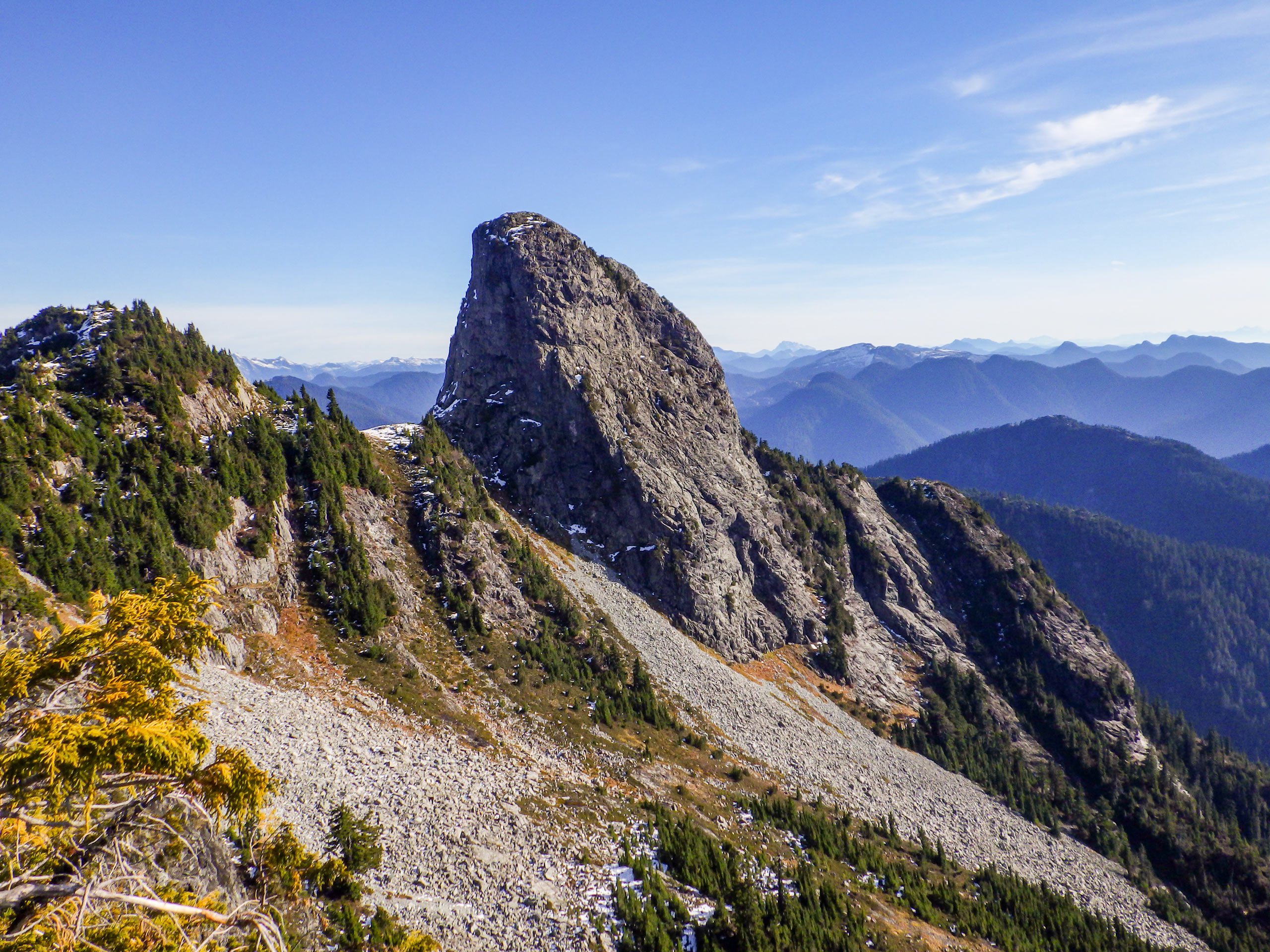
The Lions via Binkert Trail
Difficulty Rating:
The Lions via Binkert Trail is a difficult out-and-back route with sections of steep incline along a 4721ft elevation gain. While the summit of West Lion should only be attempted by experienced hikers, the trail as a whole is fairly accessible for hikers of varying skill levels, provided they are up for a tough challenge. This hike offers beautiful views of the Lions, Vancouver’s iconic landmark, as well as a panoramic view of the surrounding area.
Getting there
To get to the Lions trailhead from West Vancouver, drive north along BC-99, taking the exit for Lions Bay Avenue. Continue on Oceanview Road and make a left turn on Crosscreek Road. Turn right after 427ft onto Centre Road, and make a left onto Bayview Road. Follow along Bayview Road for 0.7mi until you reach Mountain Drive. Make a left turn, driving for another 984ft to reach Sunset Drive. Turn left, and you will arrive at the trailhead in 492ft.

About
| When to do | July-October |
| Backcountry Campsites | No |
| Pets allowed | No |
| Family friendly | No |
| Route Signage | Average |
| Crowd Levels | High |
| Route Type | Out and back |
The Lions via Binkert Trail
Elevation Graph
Weather
The Lions via Binkert Trail Description
To reach the Lions via Binkert Trail, hikers will need to travel along a technical and challenging 9.1mi route with a steep incline. This trail is an arduous climb, so be prepared with enough water and snacks to stay hydrated and keep your energy up. Also, make sure to wear proper hiking footwear that is appropriate for the season, including microspikes, as the trail can be covered in snow and/or ice. It should be noted that this route only covers the portion of the trail up to the saddle below the summit of the West Lion. The final summit of the mountain is extremely technical, with a near-vertical scramble. As such, it should only be undertaken by experienced hikers/climbers.
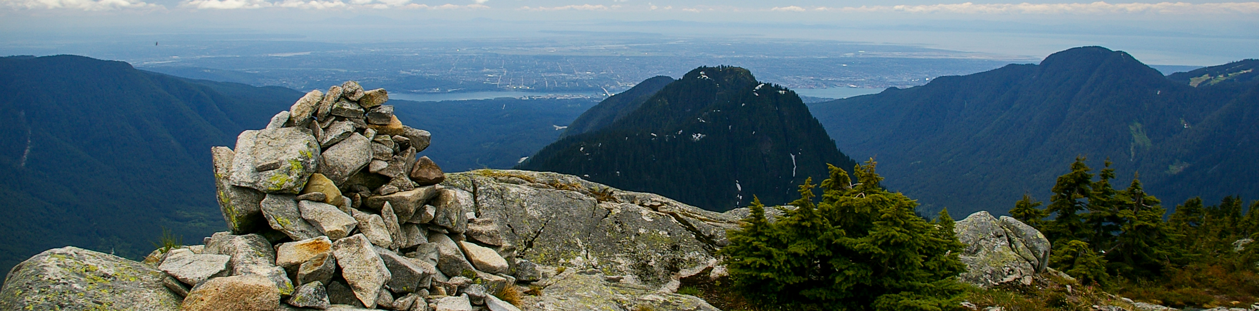
Even from the saddle below the summit of the West Lion, the views of the surrounding area are visually stunning. From this elevated vantage point, you will have a spectacular panoramic view of Howe Sound to the west, the Capilano Watershed and numerous backcountry mountains to the east, and of course, the majestic west and east Lions standing proudly next to you. The trail itself, while fairly steep and technical, takes hikers along a beautiful uphill climb through the forest, passes by a scenic waterfall, and crosses over multiple mountain streams. This is an amazing North Shore hike that should be on everyone’s bucket list.
Setting out from the parking area at the end of Sunset Drive, pass through the yellow gate and onto the gravel road to begin the climb uphill. Keep straight on the gravel road, passing by any junctions as the route begins a series of switchbacks that continue to wind uphill.
Approximately 2km from the trailhead, you will reach a junction in the trail leading to the left. Ignore this, keeping right to continue uphill for a short distance before the trail begins to level out. This next section of the route will be fairly flat, as you make your way along the trail and cross over Alberta Creek. Here, hikers will be able to catch a glimpse of a small waterfall before continuing on the trail and crossing over another three mountain streams.
0.9mi from the waterfall, you will come up on another junction in the trail with a sign pointing to the right for the Lions. Follow this path to the right, as the dirt trail becomes narrower and meets up with a bridge that crosses Harvey Creek.
Make your way across the bridge and follow the trail on the other side of the creek, as it veers to the left and begins to climb steeply uphill. You will soon reach a clearing in the trail with nice views out over Howe Sound and Bowen Island. The next stretch of trail is a difficult uphill climb, so this is a great place to take a short break before pressing on.
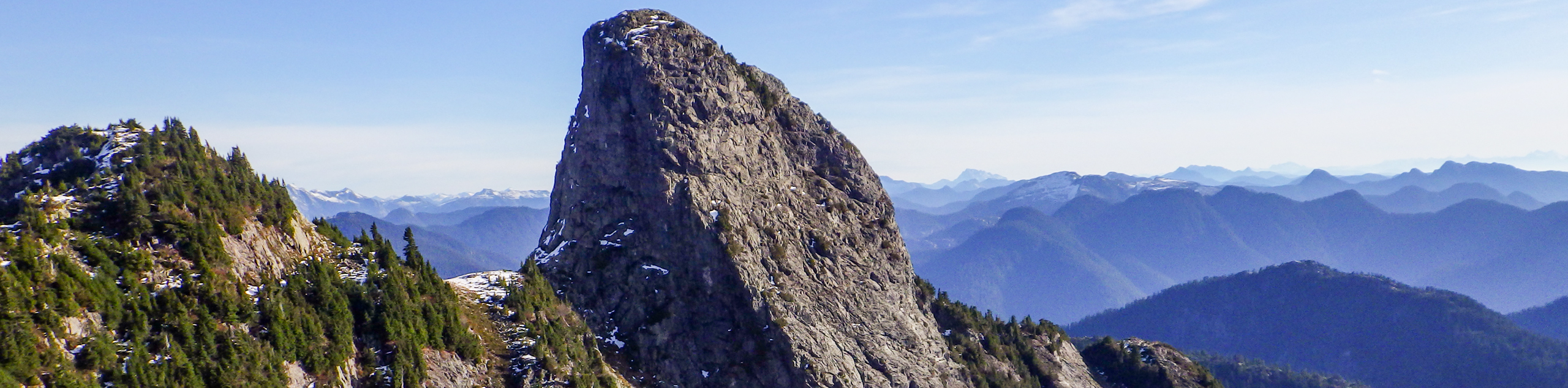
Continue on the trail as it climbs upwards through the forest of cedar and douglas fir for the next kilometre, passing by several rockslides before exiting the tree cover along the ridgeline. Looking to the right, you will be greeted with an amazing view of the West Lion protruding into the sky. There are even better views ahead, so continue on the rocky trail toward the Lions, making sure to follow the orange markers to keep on the correct path.
Make your way up this steep part of the trail, as you climb over the boulders and push your way further up the ridge. Climbing up a short gully and over the small hill, you will find yourself atop the ridge with a beautiful, unobstructed view of both Lions’ peaks standing proudly before you. From this amazing vantage point, you will also have sweeping views of Howe Sound to the west, Unnecessary Mountain to the south, and the entire Capilano Watershed to the east.
Straight ahead, the trail continues on to the summit of the West Lion. This is an extremely technical climb and should only be undertaken by experienced hikers due to the near-vertical climb and no-fall zones. If you have any doubts about your ability to climb the peak, then do not attempt it.
Take a few moments to breathe in the fresh mountain air and have a quick lunch before setting out on the return trail. Enjoy the sightline down to your starting point at Lions Bay, making sure to keep right at the junction with the Howe Sound Crest Trail, or else you will accidentally direct yourself towards the peak of Unnecessary Mountain. Continue along the same trail to return to the parking area, having reached the Lions via Binkert Trail.
Hiking Route Highlights
The Lions
Considered the most recognizable landmark in the Vancouver area, the Lions have distinctive pointed peaks that stand out amongst the rest of the Mountains on the North Shore. At over 1600m tall, these famous peaks are the namesake of the Lions Gate Bridge and the BC Lions football team.
Howe Sound
First explored by Europeans in 1791, this area was named Boca del Carmelo by Spanish explorer José María Narváez. The following year it was renamed by George Vancouver, after his friend the British Admiral Richard (Earl) Howe. This body of water opens directly into the Strait of Georgia and stretches 26.1mi northeast toward Squamish. The area is historically important to the Squamish and Shishalh indigenous peoples that have called the area home and travelled its network of waterways for thousands of years.
Unnecessary Mountain
Summiting this mountain peak used to be a part of the route to reach the Lions, but has since diverted around it, deeming it “unnecessary.” Challenging in its own right, this peak offers beautiful views of the surrounding area, and is anything but unnecessary.
Insider Hints
Parking along Sunset Drive is limited. Arrive early to ensure that you get a spot.
Bring microspikes to help you traverse the route in icy conditions.
Pay attention to the orange trail markers to stay on the rocky upper portion of the trail.
Avoid the summit of West Lion unless you are an experienced climber.
As with many North Shore trails, bring bear spray just to be safe.
Similar hikes to the The Lions via Binkert Trail hike
Hike to South Needle
The Hike to South Needle follows along an extension of the trail to Lynn Peak, passing by the viewpoint and…

Lynn Lake Trail
The Lynn Lake Trail is a lengthy hike through the Lynn Headwaters backcountry that is sure to get you off…

Old Buck and Bridle Trail Loop
The Old Buck and Bridle Trail Loop is an amalgamation of the Old Buck, Bridle, and Baden Powell trails that…
Comments