Mount Elsay Trail
View Photos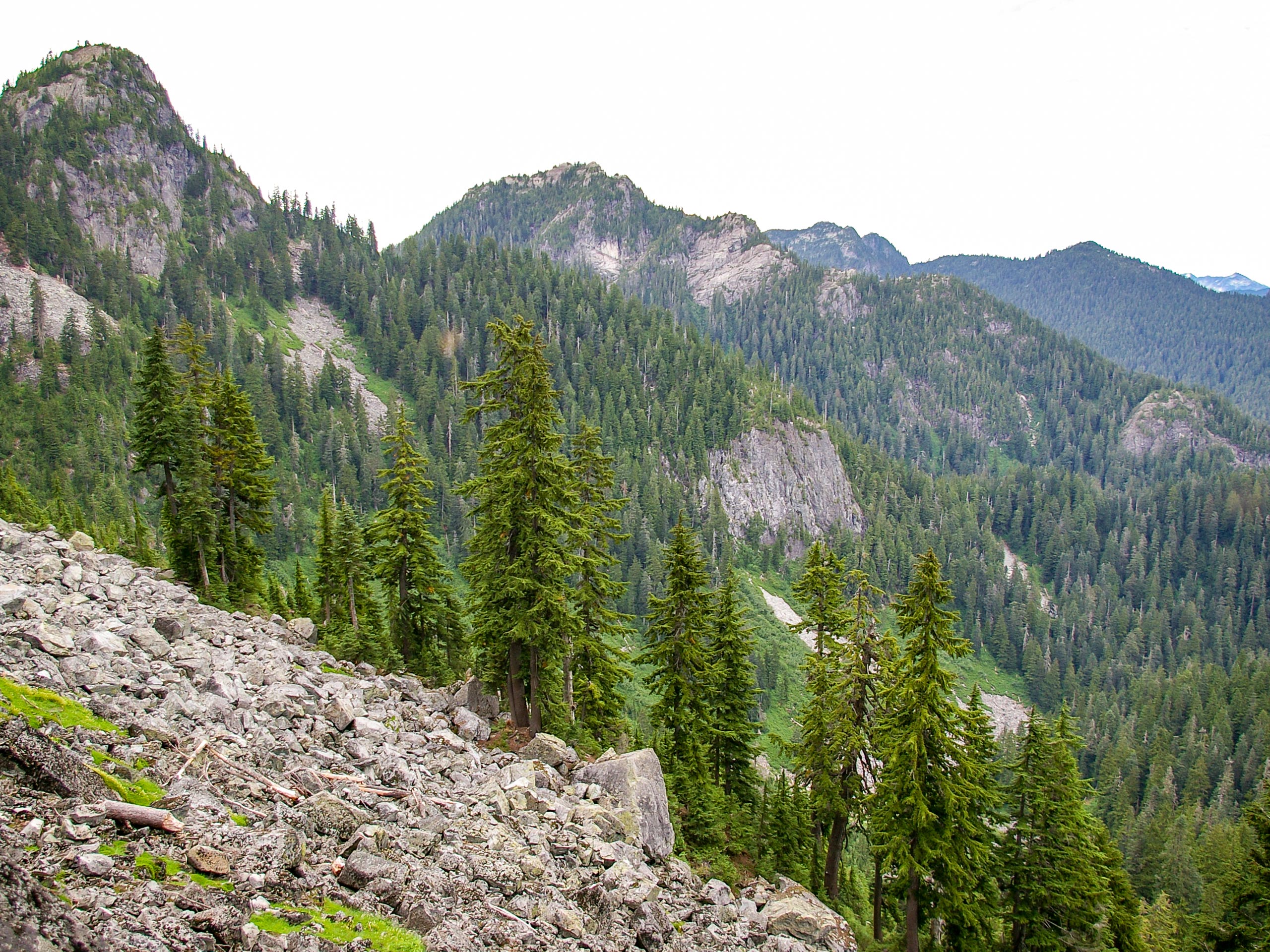
Mount Elsay Trail
Difficulty Rating:
The Mount Elsay Trail is a beautiful 9.3mi loop trail in the backcountry of Mount Seymour Provincial Park. A less travelled route than some of its neighbours, this trail is poorly marked in certain areas and has several technical sections traversing loose rock. Anyone willing to brave this physically demanding route will be rewarded with stunning North Shore views from a vantage point that few experience.
Getting there
To get to the Mount Elsay trailhead from Vancouver, take the Trans Canada Highway/BC-1 West and drive over Ironworkers Memorial Bridge. Take exit 22B toward Mount Seymour Parkway, turning left after 4.3mi on to Mount Seymour Rd. Drive north for 13km and you will reach the parking lot.

About
| When to do | July-October |
| Backcountry Campsites | No |
| Pets allowed | Yes |
| Family friendly | No |
| Route Signage | Poor |
| Crowd Levels | Moderate |
| Route Type | Circuit |
Mount Elsay Trail
Elevation Graph
Weather
Mount Elsay Trail Description
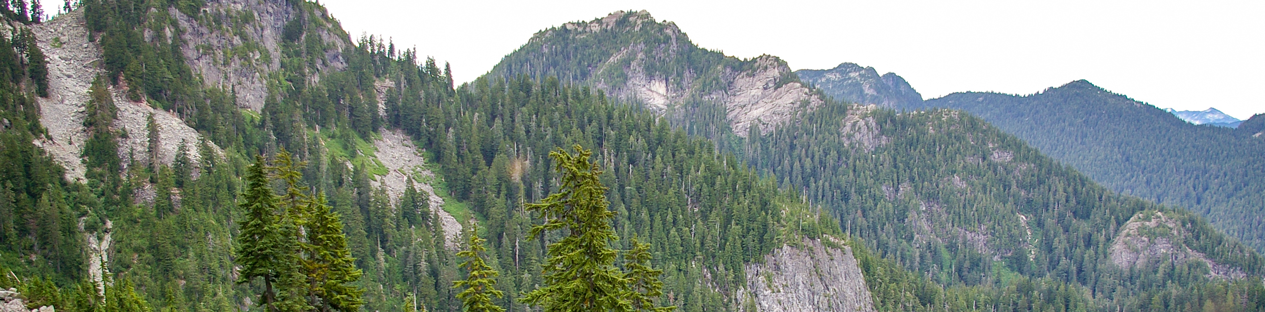
The Mount Elsay Trail is a difficult hike that should not be undertaken by new hikers or anyone without a fair amount of backcountry experience. Sections of this trail can be difficult to navigate, as they are poorly marked, and the cumulative elevation gain is a lot greater than the 1378ft difference between the trailhead and summit would suggest. Additionally, the trail is very rugged, with exposed rocky sections and a large boulder field that hikers will be required to navigate. This is a lightly travelled route that breaks off from the main trail leading to Mount Seymour, so once you have made your way beyond this junction, there is a small likelihood of crossing paths with other travellers.
The upside to this backcountry adventure is that it provides the perfect opportunity for a bit of solitude once you break away from the highly-trafficked main trail to Mount Seymour. This challenging hike will take you up the First Pump and Tim Jones peaks before skirting around Mount Seymour toward Elsay Lake and Mount Elsay itself. From here, hikers will be rewarded with a panoramic view of the surrounding area that few will make the effort to witness. Take in the views of Mount Bishop and Elsay Lake nestled between the mountains to the north, and gaze back along the lengthy trail toward Mount Seymour and Runner Peak to the south. The Mount Elsay Trail is an underrated day hike with beautiful views that should be far more popular than it is.
As mentioned, the lower portion of this route utilizes the main trail leading to Mount Seymour, so hikers will need to make their way toward its trailhead. Head to the north end of the parking lot, past the BC Parks sign and toward the ski run. You will soon reach a junction with the trail for Dog Mountain on your left. Ignore this and follow the second trail on the left, as this will take you on the path to Mount Seymour.
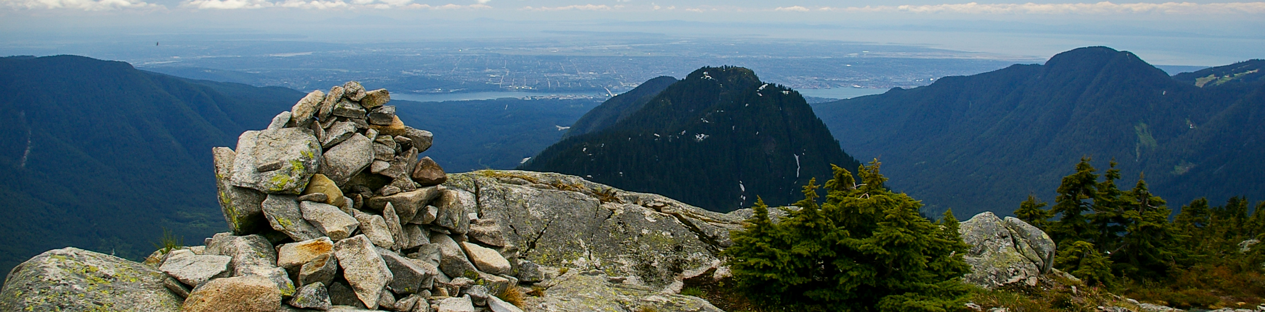
Continue on this trail for 0.6mi, making sure to follow the markings for Mount Seymour. You will eventually reach a dirt access road. Follow this to the left, as you skirt around the Mystery Peak ski area, picking up the trail as it enters into tree cove alongside Sugar Bowl Pond. As the trail climbs, you will get to a rocky outcrop known as Brockton Point, where you will be able to catch some stunning views of Vancouver off in the distance.
Making your way up the trail for another 2297ft, you will come to a junction with a path to the right that will be marked for Elsay Lake. You can ignore this, as it will be your return path on the backside of the trail loop. Instead, follow the trail to the left, making your way up the steep incline toward First Pump Peak. Keep an eye out for orange trail markers on the rocks, as these will be your only guide as you weave your way towards the peak. If you want to access the lookout to see some more views of the city, follow the short side trail to the left to get to the highest point of the peak.
Back on the main trail, move beyond the green trail marker and follow the path as it leads to the right. Again, orange trail markers will be your best friend for this section of the hike, as they will help you to navigate the rocky terrain.
Here, the trail will briefly descend before beginning a steep climb as you make your way toward Tim Jones Peak. The steep slope and loose rock make this stretch of the hike fairly technical, but once you reach the peak you will be able to take in some amazing views of Lynn Peak, Crown and Coliseum mountains, and South Needle.
After taking in the sights from Tim Jones Peak, return to the main trail and follow it north towards Mount Seymour. Be cautious with your footing, as this steep drop is very technical and can become difficult to traverse in snowy/icy conditions. As you drop down along the trail, you will reach the col before Mount Seymour. To your left, there will be a slightly hidden trail that breaks off down into a gully to skirt its way around Mount Seymour. Take some time to look for the trail, which will be marked with a piece of yellow tape on one of the trees. Once you have found the marker, safely descend onto the Mount Elsay Trail, following a line of pink trail ribbons as you lose 150m of elevation. From here, the trail will head north, as you enter back into tree cover.
This section of the trail is poorly marked and fairly rugged, but it will be distinctive enough to navigate. Keep following the pink ribbons, as the trail climbs steeply uphill and you will soon reach a small scree, where the trail splits to the left and into the trees.
As you exit the trees and into an area with a rocky bluff, you will need to keep left on the trail, following the pink trail ribbons as you make your way onto the rocky outcrop. At this point, the trail markings will switch to orange, as it drops steeply down the other side of the bluff. Looking out over the rocky slope, you will see a series of cairns, with an orange trail marker on a tree across the way. Follow this route to pick up the trail on the other side.
Continue on the path as it heads through the trees before coming up on another scree. Using the same tactic, follow the cairns as you make your way across the slope, picking the trail back up on the other side. As you find yourself on a ridge to the north of Mount Seymour, the trail will have some slight changes in elevation until you reach a junction. Take note of this, as the junction is unmarked, and the trail to the right will be your return course along the eastern portion of the trail loop. Make your way to the left, continuing uphill toward Mount Elsay.
As you get to the top of the hill, you will reach another junction in the trail. Continue heading straight for 0.6mi, making the final push up the steep incline to Mount Elsay. The trail is a bit overgrown here, so keep an eye out for trail markings that will guide you on your way.
Making your way up the exposed section of rock, you will notice the sweeping views of the surrounding area begin to open up, indicating that you are almost at the summit. As you make your way to the top of Mount Elsay, you will be greeted with 360° panoramic views from a vantage point that most hikers do not reach. From here, you will have access to gorgeous views of Mount Seymour and Runner Peak to the south, and to the north, you will see Mount Bishop standing tall, with Elsay Lake nestled quietly in the valley below. Take a few moments to breathe in the crisp mountain air before setting out on the long return journey around the other side of the loop.
Working your way down from the summit for 0.6mi, you will approach the unmarked junction that leads on the return loop of the trail. Follow this to the left and you will soon reach a larger boulder field. Watch your footing as you traverse this tiresome and technical portion of the trail, following along the rock cairns to make your way to the bottom. Once there, you will find a small creek of fresh mountain water that will be your last source until the end of the hike.
Just beyond the creek, the trail will re-enter the forest. Follow it downhill until you get to a junction with an orange trail marker. Take this to the right to make your way along a fairly flat 1.2mi stretch in the direction of Mount Seymour. Again, you will need to cross a few scree slopes before the trail begins working its way uphill.
Continue on the trail and up the series of switchbacks, making the 300m climb known as Wes’ Ascent. After completing this grueling portion of the hike, you will undoubtedly be very tired, but you will have reached the initial junction with the Mount Seymour Trail. Follow the path to the left to retrace the first steps of your hike for 1.9mi until you reach the parking lot, having completed the seldom-travelled Mount Elsay Trail.
Hiking Route Highlights
Tim Jones Peak
A sub-peak of Mount Seymour, this peak used to be unofficially named Second Pump Peak, as it is the second peak on the way to Mount Seymour. It was renamed in 2017, after Tim Jones, who passed away in 2014 and was a dedicated member of the North Shore Rescue team.
Elsay Lake
Originally known as Mystery Lake, this body of water in Mount Seymour Provincial Park was renamed Lake Elsay, after the nearby Elsay Creek. Nestled in the backcountry between mounts Bishop and Elsay, this picturesque lake is the perfect place for a refreshing summertime swim… if you can get to it.
Insider Hints
During the summer months, parking costs $3 and can be paid with cash or card.
Check the trail signs at the start of the hike to learn about trail conditions.
Wear proper hiking footwear, as portions of the trail can be covered in loose rock. Also, bring winter gear such as crampons, snowshoes, or skis, as the trail can be covered in heavy snow and ice.
Take opportunities to stock up on fresh water where available, as the final portion of the hike is very tiring.
Stay vigilant on poorly marked sections of the trail to stay on course.
Similar hikes to the Mount Elsay Trail hike
Hike to South Needle
The Hike to South Needle follows along an extension of the trail to Lynn Peak, passing by the viewpoint and…

Lynn Lake Trail
The Lynn Lake Trail is a lengthy hike through the Lynn Headwaters backcountry that is sure to get you off…

Old Buck and Bridle Trail Loop
The Old Buck and Bridle Trail Loop is an amalgamation of the Old Buck, Bridle, and Baden Powell trails that…
Comments