
Lower Cannon Lake Hike
View Photos
Lower Cannon Lake Hike
Difficulty Rating:
Immerse yourself in the Rocky Mountains along the Lower Cannon Lake Hike. This beautiful adventure explores the alpine, featuring wildflowers, montane meadows, mixed woodlands, and spellbinding views of the Seven Devils Mountains.
Getting there
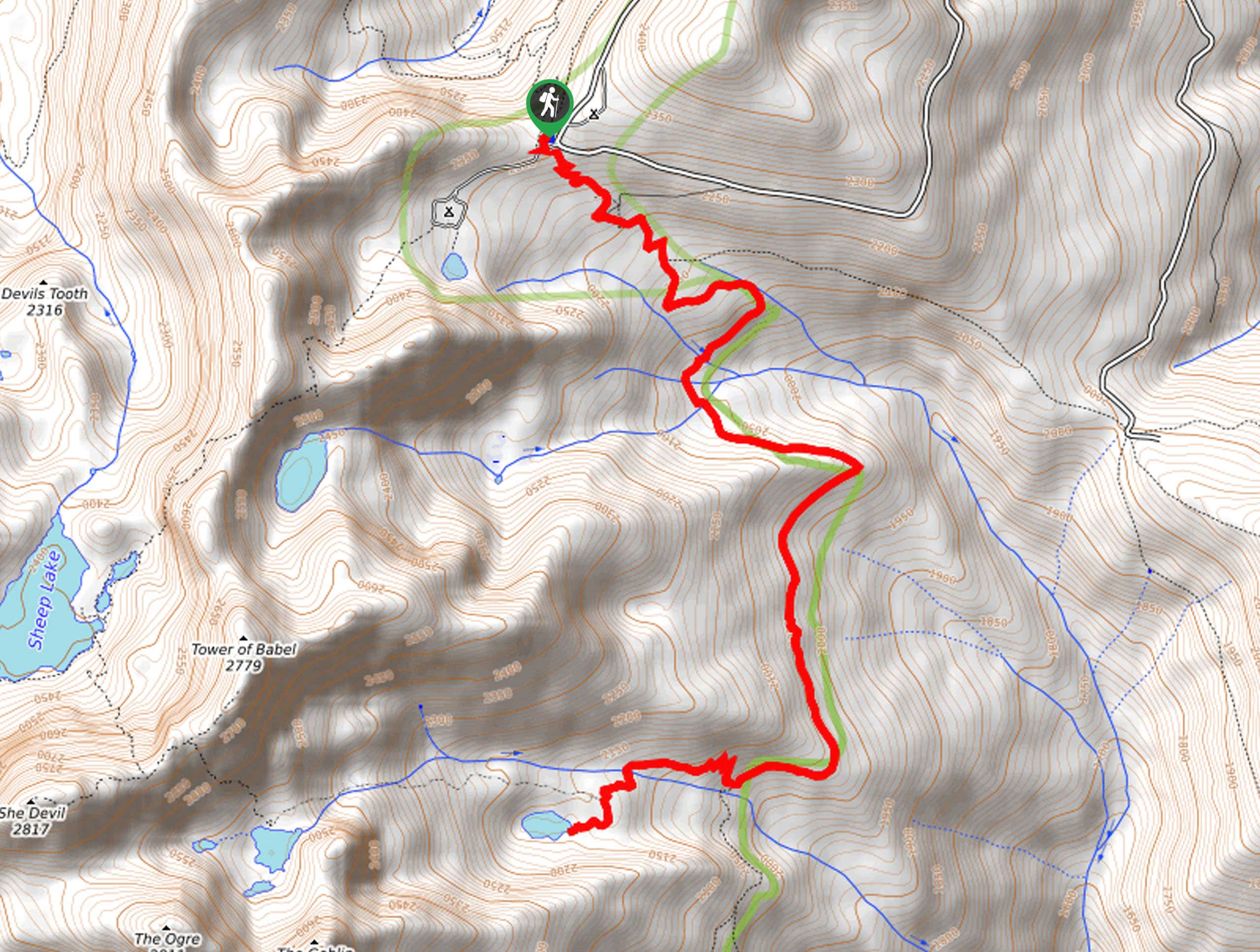
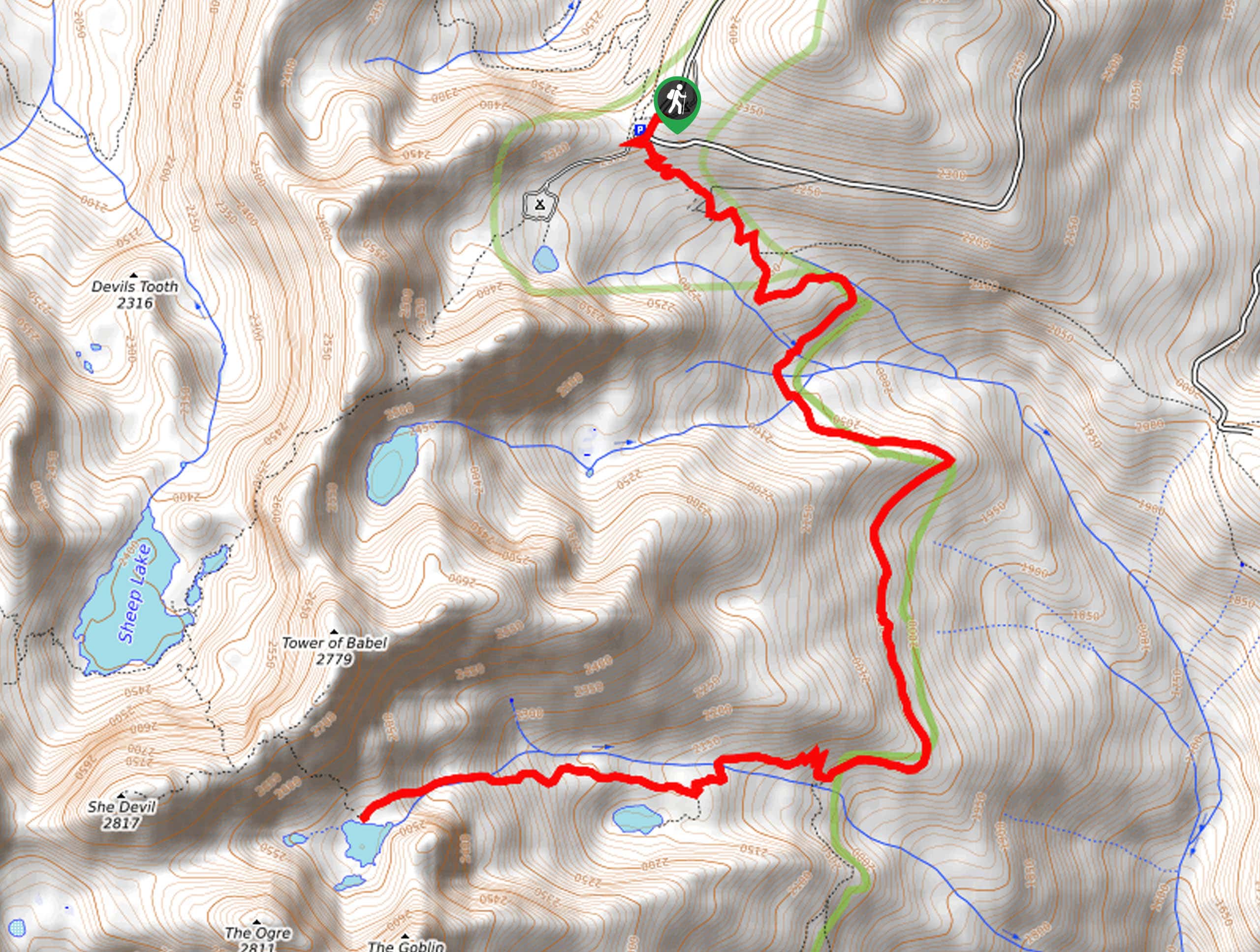
The Lower Cannon Lake Hike departs from the Windy Saddle Trailhead off Seven Devils Road.

About
| Backcountry Campground | Backcountry Camping |
| When to do | April-September |
| Pets allowed | Yes - On Leash |
| Family friendly | Older Children only |
| Route Signage | Average |
| Crowd Levels | Moderate |
| Route Type | Out and back |
Lower Cannon Lake Hike
Elevation Graph
Weather
Lower Cannon Lake Hike Description
Hiking the Lower Cannon Lake Trail makes for an unforgettable experience. This beautiful high-country hike is simply breathtaking, and we cannot recommend it enough. The road up to the trailhead is steep, so give your breaks a test before heading out! Note there are a few stock gates along the trail; make sure you close them behind you as you hike. While the exposed terrain offers mesmerizing views, it also warrants extreme conditions, so dress in layers and prepare for windy conditions. If you are heading out in the summer, make sure to bring a swimsuit and towel so you can enjoy the crystalline pool.
Setting out from the Windy Saddle Trailhead, those heading to Lower Cannon Lake will track the South Boise Trail heading southwest. Steeply descending, you will encounter a few intersections, keep right, maintaining on the South Boise Trail. After some hiking, you will have to ford a few creeks, one being Bridge Creek. Be sure to admire the encompassing dramatic landscape as you wander. Eventually, the path will redirect you west, running parallel to Cannon Creek.
Here you will merge onto the Cannon Lake Trail, which will steeply climb to the lakeshore. Admire the beauty of the crystal-clear lake and the looming bluffs anchored by the Seven Devils Mountains. Notice The Goblin in the west and the Tower of Babel in the northwest. After reveling in the scenery, retrace your footing along the path to the trailhead.
Similar hikes to the Lower Cannon Lake Hike hike
Lewis and Clark Trail
The Lewis and Clark Trail is an excellent hike for those seeking an easy-going meander or a doable hike for…
Mount Sampson and Cannon Ball Mountain Hike
Treat yourself to spellbinding views of the Seven Devil Mountains along the Mount Sampson and Cannon Ball Mountain Hike. This…
Upper Cannon Lake Hike
The Upper Cannon Lake Hike is a long and involved adventure into the Seven Devils Mountains in the Nez Perce…
Comments