
Rampart Ridge Hike
View Photos
Rampart Ridge Hike
Difficulty Rating:
The Rampart Ridge hike is a loop trail in Mount Rainier National Park that is moderately challenging and generally less busy than many other trails in the area. The trail climbs steadily, offering a nice challenge without being overwhelming. There’s a unique natural arched tree on this trail that makes for a great photo spot!
Getting there
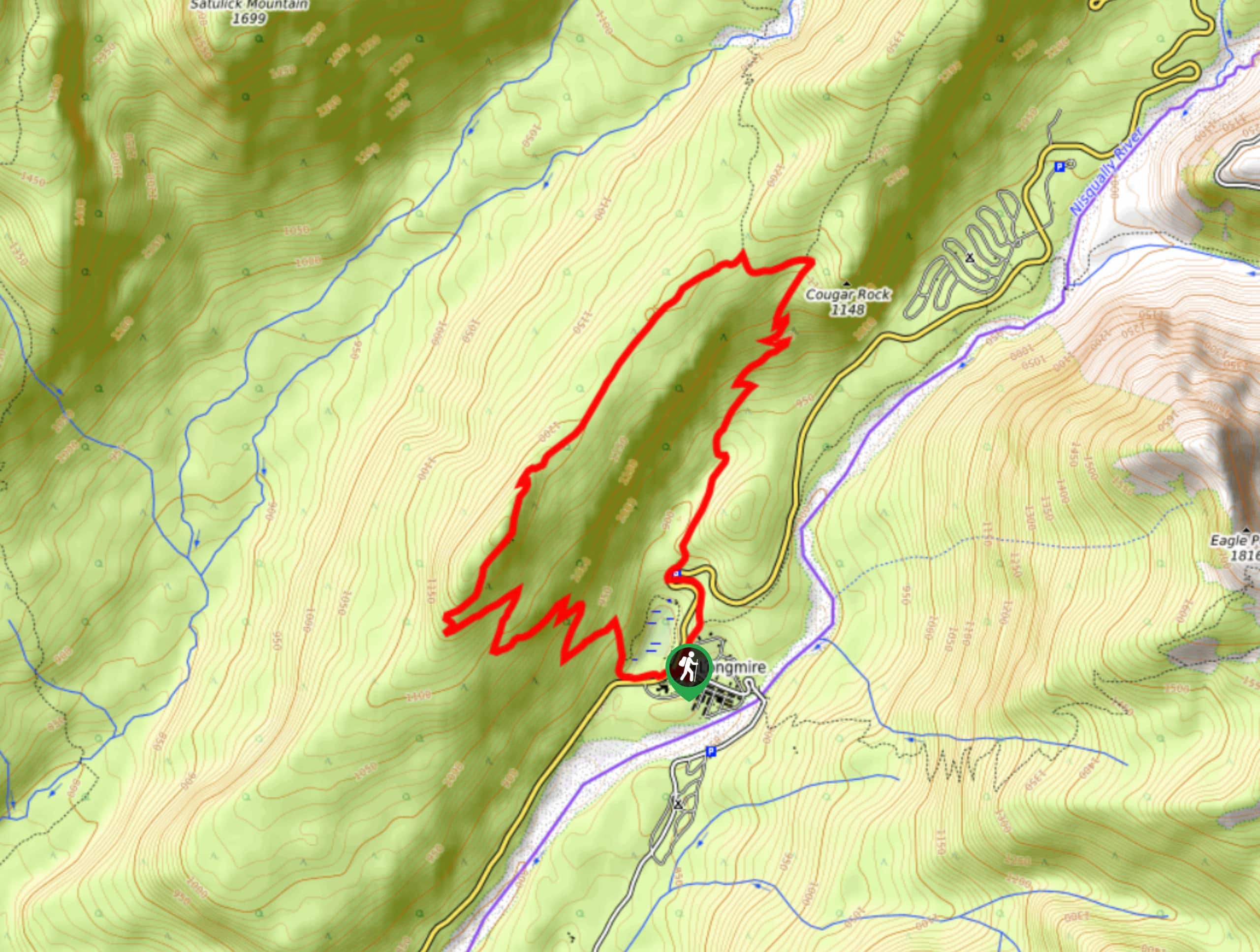
To get to the Rampart Ridge trailhead from Elbe, take Highway 706 east into the park. Continue along Paradise Road to Longmire, where you’ll park in the parking area.

About
| Backcountry Campground | No |
| When to do | June-October |
| Pets allowed | No |
| Family friendly | Older Children only |
| Route Signage | Average |
| Crowd Levels | Moderate |
| Route Type | Circuit |
Rampart Ridge Hike
Elevation Graph
Weather
Rampart Ridge Hike Description
The Rampart Ridge hike is a lesser-known hike in Mount Rainier National Park that offers a moderate physical challenge. This trail isn’t quite as scenic as others in the area, but provides respite from the crowds, views of Mount Rainier, and a unique natural tree arch that are all worth seeing. However, bug spray is essential for this hike.
Begin your hike across the road from the Longmire buildings, following the signs for the Trail of the Shadows. You’ll soon arrive at a junction where the Rampart Ridge trail switchbacks up to your left.
Taking the left-hand trail, climb up the switchbacks. The tree arch is in the switchback section. You’ll come to another junction just before the peak of your trail. Keep going, cresting the ridge to find a great view of Mount Rainier. This is the best view of the hike, so enjoy it!
Traverse the ridge further before taking a gentle descent. The route meets the Wonderland Trail 1.2mi from the viewpoint. Turn right here and descend for 1.9mi to Longmire.
You can hike this route counterclockwise instead if you’d prefer to have a gentler start and then descend on the switchbacks.
Similar hikes to the Rampart Ridge Hike hike

Paul Peak Trail
The Paul Peak Trail is a 6.3mi lightly trafficked out and back trail in Mount Rainier National Park…

Narada Falls to Mazama Ridge Loop
The Narada Falls to Mazama Ridge loop is an 7.4mi moderately trafficked route in Mount Rainier National Park…

Camp Summerland via Wonderland Trail
The hike to Camp Summerland on the Wonderland Trail is a 8.4mi moderately trafficked out and back trail…
Comments