
Goat Island Mountain Trail
View Photos
Goat Island Mountain Trail
Difficulty Rating:
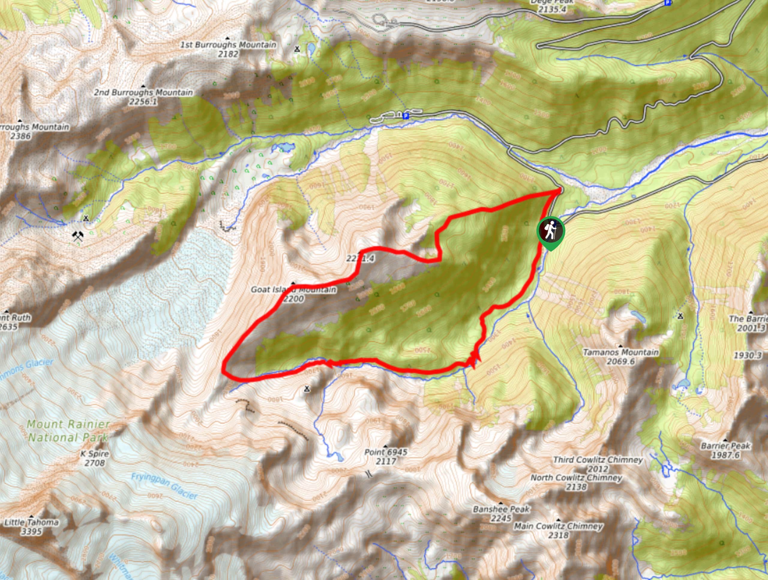
The Goat Island Mountain Trail is a 8.7mi lightly trafficked loop trail in Mount Rainier National Park that is rated as difficult. This trail not only requires fair distance and elevation gain, but the trail is poorly defined and most hikers end up bushwhacking or experiencing navigational difficulties. Please bring a detailed map or GPS tracking with you to attempt this hike.
Getting there
The trailhead for the Goat Island Mountain Hike is off Sunrise Park Road where the parking for the Summerland Trail is.

About
| Backcountry Campground | No |
| When to do | June-October |
| Pets allowed | No |
| Family friendly | No |
| Route Signage | Poor |
| Crowd Levels | Low |
| Route Type | Loop |
Goat Island Mountain Trail
Elevation Graph
Weather
Goat Island Mountain Trail Description
The Goat Island Mountain Trail is no hike to take lightly, as a poorly defined trail in parts can present navigational challenges. Many hikers end up bushwhacking parts of this hike, and portions are too steep to safely descend should you get lost. Please bring a GPS to enjoy this trail!
The hike begins at the trailhead for Summerland. We recommend going counterclockwise as the initial ridge would be very challenging to descend. Begin at the foot of the ridge and ascend directly up the ridgeline. There is a game trail about 20ft south of the ridge that you can take if you lose the trail. Watch for old-growth trees in the forest.
As you approach the top of the ridge, try not to aim too high. You’ll want to be positioned south of the upcoming gully to hike below it and then re-ascend on the other side. Don’t attempt to hike straight down the gully if you’ve gone too far. We recommend crossing the gully between 5900ft and 6200ft. Some hikers prefer to cross through the bowl north of the ridge at around 6170ft, ascend the first ridge, and hike directly over to the second. Try whichever route you feel most comfortable doing.
Take care when re-ascending the ridge. We recommend staying just below the treeline to follow the meadow into a pumice field. Enjoy views of the Cowlitz Chimneys here. Push on to the summit, following the ridgeline. The views of Rainier and the glaciers here are fantastic.
To descend, you’ll need to carefully navigate large boulders, hopping onto animal paths heading down the ridge if you find them. Nearing the bottom of the ridge, you’ll descend through a meadow to a steep dry creekbed. You’ll want to either descend right down the creekbed or on the sides depending on where the ground feels more stable.
Off the ridge and through the creekbed, you’ll curve to the left to approach Summerland Trail. Cross Fryingpan Creek and follow Wonderland Trail as it runs above the creek. This will take you back to the parking lot.
Similar hikes to the Goat Island Mountain Trail hike

Paul Peak Trail
The Paul Peak Trail is a 6.3mi lightly trafficked out and back trail in Mount Rainier National Park…

Narada Falls to Mazama Ridge Loop
The Narada Falls to Mazama Ridge loop is an 7.4mi moderately trafficked route in Mount Rainier National Park…

Camp Summerland via Wonderland Trail
The hike to Camp Summerland on the Wonderland Trail is a 8.4mi moderately trafficked out and back trail…
Comments