
Teneriffe Falls via Mount Si Trail
View Photos
Teneriffe Falls via Mount Si Trail
Difficulty Rating:
Teneriffe Falls via Mount Si Trail is a heavily trafficked lollipop trail in the Mount Si Natural Resources Conservation Area that is rated as moderate. Teneriffe falls are gorgeous when flowing, but that’s part of the trip planning needed for this hike: try to hike this trail earlier in the season as the falls can dry up later into the summer. While this isn’t a hard hike, the trail can get a little rocky or overgrown in spots.
Getting there
The trailhead for the hike to Teneriffe Falls on Mount Si Trail is off SE Mount Si Road between 461st Ave SE and 464th Ave SE.

About
| Backcountry Campground | No |
| When to do | May-October |
| Pets allowed | Yes - On Leash |
| Family friendly | Older Children only |
| Route Signage | Poor |
| Crowd Levels | High |
| Route Type | Lollipop |
Teneriffe Falls via Mount Si Trail
Elevation Graph
Weather
Teneriffe Falls via Mount Si Trail Description
Teneriffe Falls via Mount Si Trail is a rewarding trip through a refreshing, moody forest to a waterfall with mountain vistas. Hikers will share the trail with others heading to the summit of Mount Teneriffe and Mount Si, so the hike can get a bit crowded. Plan to tackle this adventure in the early morning or during the week to minimize traffic. While most of the trail is well-maintained and easy to follow, some sections are overgrown and a bit rocky, so good boots can be helpful here.
Note that the falls don’t always have water flowing. Try to do this hike in the late spring for the best chance of a real waterfall experience as they are prone to drying up through the summer.
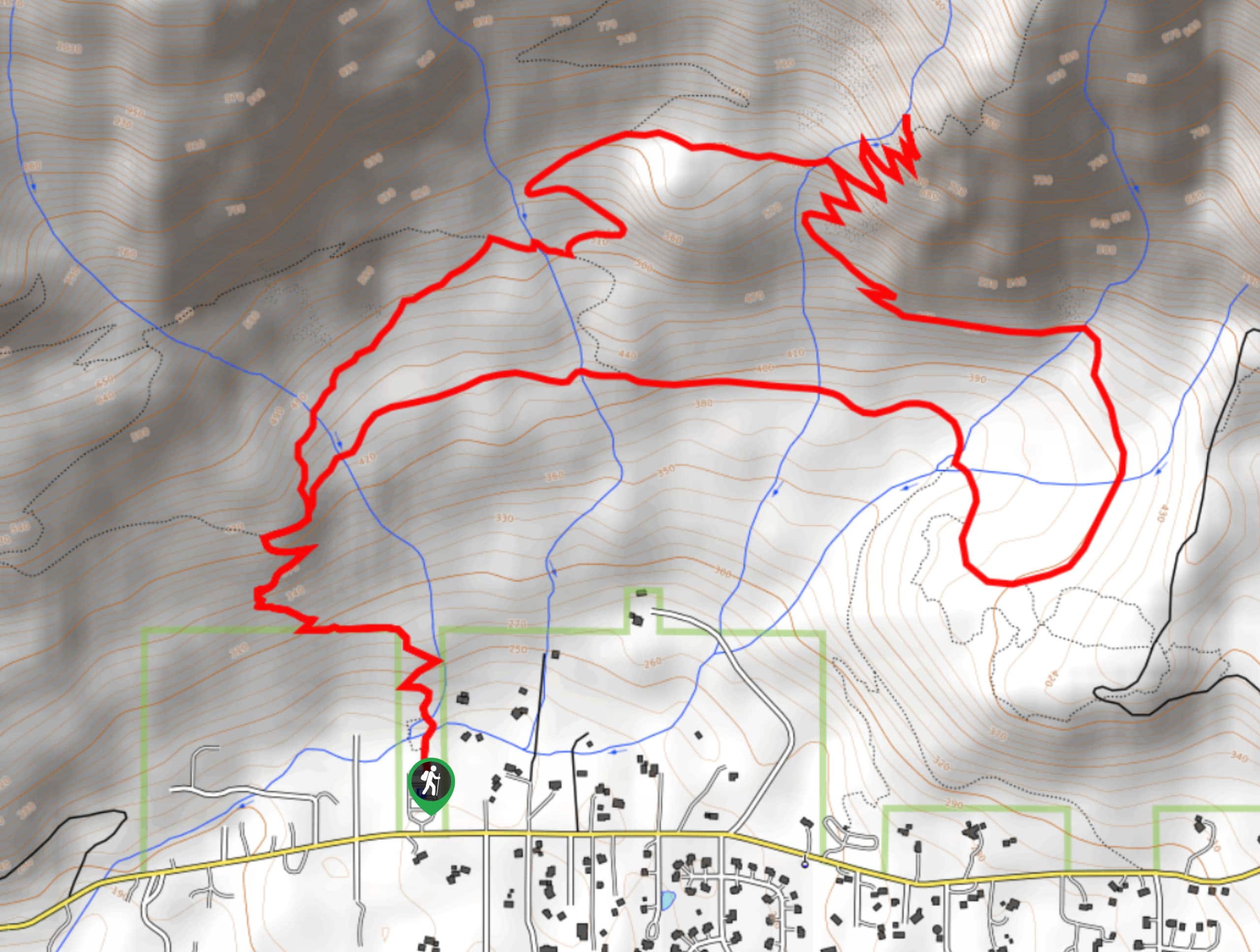
The hike begins from the parking area. Head north, coming to a junction between Roaring Creek Trail and Mount Si Trail. We recommend going clockwise on this loop to leave the steep switchbacks for the descent- they’re a bit tiring to go up, but they’re not too steep to descend comfortably.
Stay left onto Talus Loop Trail, crossing the stream and gently gaining elevation. At the T-junction, go right, crossing the stream again and then staying left to take the Tenerife Falls Connector. You’ll stay right onto the connector at the junction with Mount Teneriffe Trail.
Cross a mostly flat section to another stream crossing, then pick up the switchbacks halfway through them (cutting down your workout, thankfully) on Teneriffe Falls Trail. Ascend through a few turns, arriving at the falls by staying left after the last turn.
After enjoying the falls, descend the switchbacks, staying straight onto Tenerife Falls Trail instead of taking the connector. The trail evens out, crosses a stream, and then dips down over another stream before looping back up to a junction with Mount Teneriffe Trail. Stay right onto Mount Teneriffe Trail, hiking a mostly flat section to the junction with Roaring Creek Trail. Stay left, cross two streams, and then rejoin Mount Si Trail to head back to the trailhead.
Similar hikes to the Teneriffe Falls via Mount Si Trail hike

Lakes Dorothy, Bear, Deer, and Snoqualmie Hike
The Lakes Dorothy, Bear, Deer, and Snoqualmie Hike provides access to Lake Dorothy, Bear Lake, Deer Lake, and Snoqualmie Lake.…

Gold Creek Trail to Joe Lake
Gold Creek Trail to Joe Lake is not a hike for the faint of heart. This lightly trafficked trail is…

Basin Lake via Bullion Basin Trail
Basin Lake via Bullion Basin Trail is a 12.2mi hike that, with 2900ft of elevation gain,…
Comments