Boulder Lake Trail
View Photos
Boulder Lake Trail
Difficulty Rating:
Boulder Lake Trail is an 7.3mi lightly trafficked out and back trail in Glacier Peak Wilderness that is rated as hard. This hike leads to a gorgeous lake framed by jagged rock walls, but getting there isn’t exactly straightforward. The drive in is overgrown (careful with your car) and the trail itself is initially clear before fading away, requiring reliance on GPS to reach the lake. If you have a downloaded route and you’re ready to persevere, you’re likely to have the lake all to yourself.
Getting there
The trailhead for the Boulder Lake Trail is at the end of National Forest Development Road 2660. The road is overgrown and some hikers report scratching their cars, so go slowly.

About
| Backcountry Campground | No |
| When to do | May-October |
| Pets allowed | Yes - On Leash |
| Family friendly | No |
| Route Signage | Poor |
| Crowd Levels | Low |
| Route Type | Out and back |
Boulder Lake Trail
Elevation Graph
Weather
Boulder Lake Trail Description
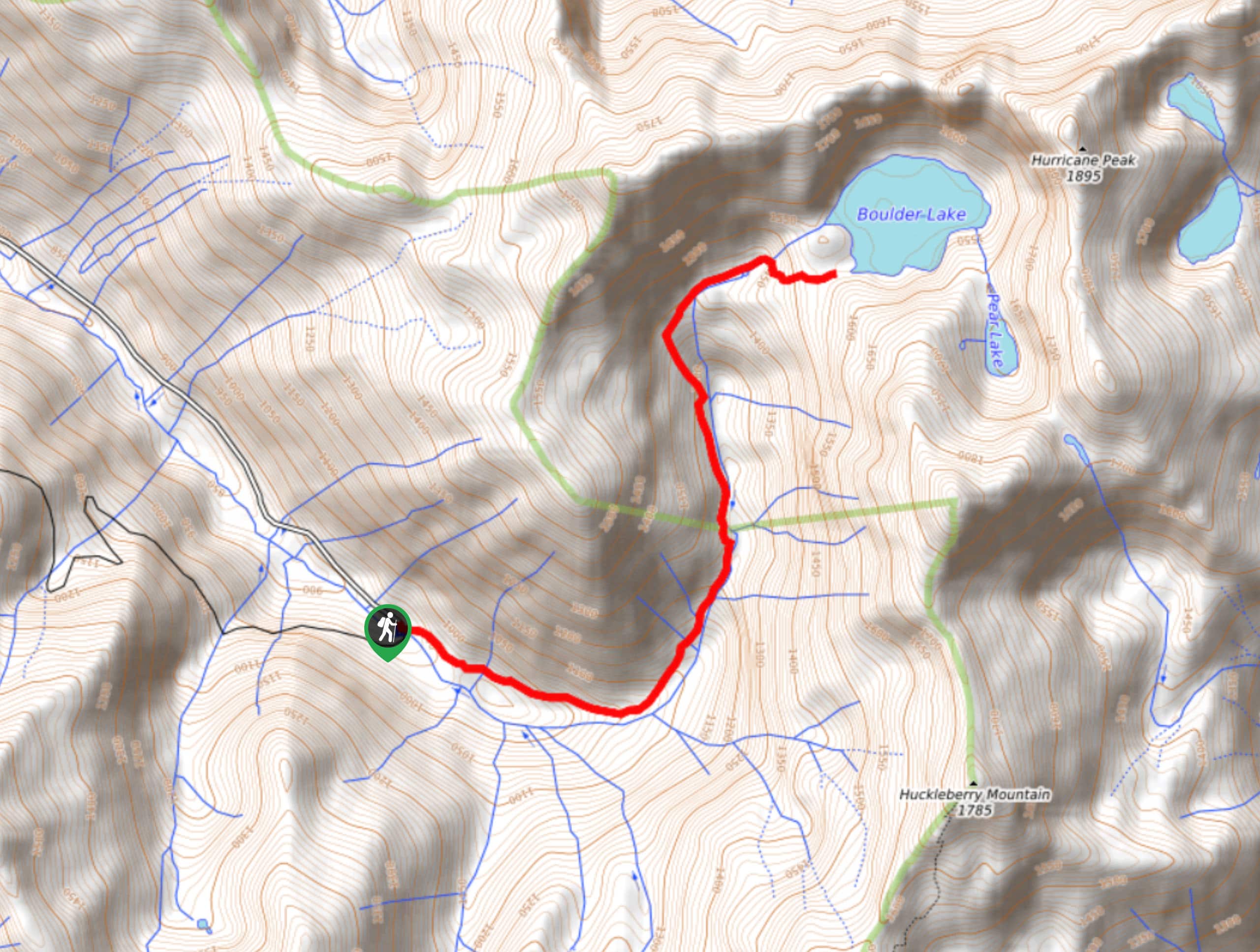
Let’s get this straight: Boulder Lake Trail isn’t well-maintained, isn’t very clear to follow, and isn’t a casual walk in the woods. It’s difficult to follow, unclear at times, and easy to lose. That being said, the lake at the end of the trail is truly stunning, and if you can reach it, you’re quite likely to have it all to yourself. Arm yourself with a reliable GPS track and prepare to bushwhack a little and you’ll be rewarded for your hard work at the shores of this alpine lake.
The trail begins from the end of the access road, which is an adventure in itself. Hike roughly southeast, crossing a small arm of Tenas Creek while keeping the main creek on your right. The trail roughly follows the creek as it curves north.
A couple of small stream crossings bring you closer to the creek. The trail becomes much less obvious here, but if you keep the creek close by on your right-hand side, you’ll continue to approach the lake. Just before reaching the lake, the trail crosses the creek, and you’ll soon have the shores in your sight.
On the return trip, keep Tenas Creek on your left-hand side. If you drift too far away, you may lose the trail. The trail should reveal itself closer to the parking lot.
Similar hikes to the Boulder Lake Trail hike

Lakes Dorothy, Bear, Deer, and Snoqualmie Hike
The Lakes Dorothy, Bear, Deer, and Snoqualmie Hike provides access to Lake Dorothy, Bear Lake, Deer Lake, and Snoqualmie Lake.…

Gold Creek Trail to Joe Lake
Gold Creek Trail to Joe Lake is not a hike for the faint of heart. This lightly trafficked trail is…

Basin Lake via Bullion Basin Trail
Basin Lake via Bullion Basin Trail is a 12.2mi hike that, with 2900ft of elevation gain,…
Comments