
Teneriffe Falls via Mount Teneriffe Trail
View Photos
Teneriffe Falls via Mount Teneriffe Trail
Difficulty Rating:
Teneriffe Falls via Mount Teneriffe Trail is a heavily trafficked out-and-back trail in the Mount Si Natural Resources Conservation Area that is rated as moderate. These falls are gorgeous when flowing, but that’s part of the trip planning-try to hike this trail earlier in the season as the falls can dry up later into the summer. While this isn’t a very challenging hike, it does get rocky and a bit harder to follow near the end, so good boots and GPS will be helpful.
Getting there
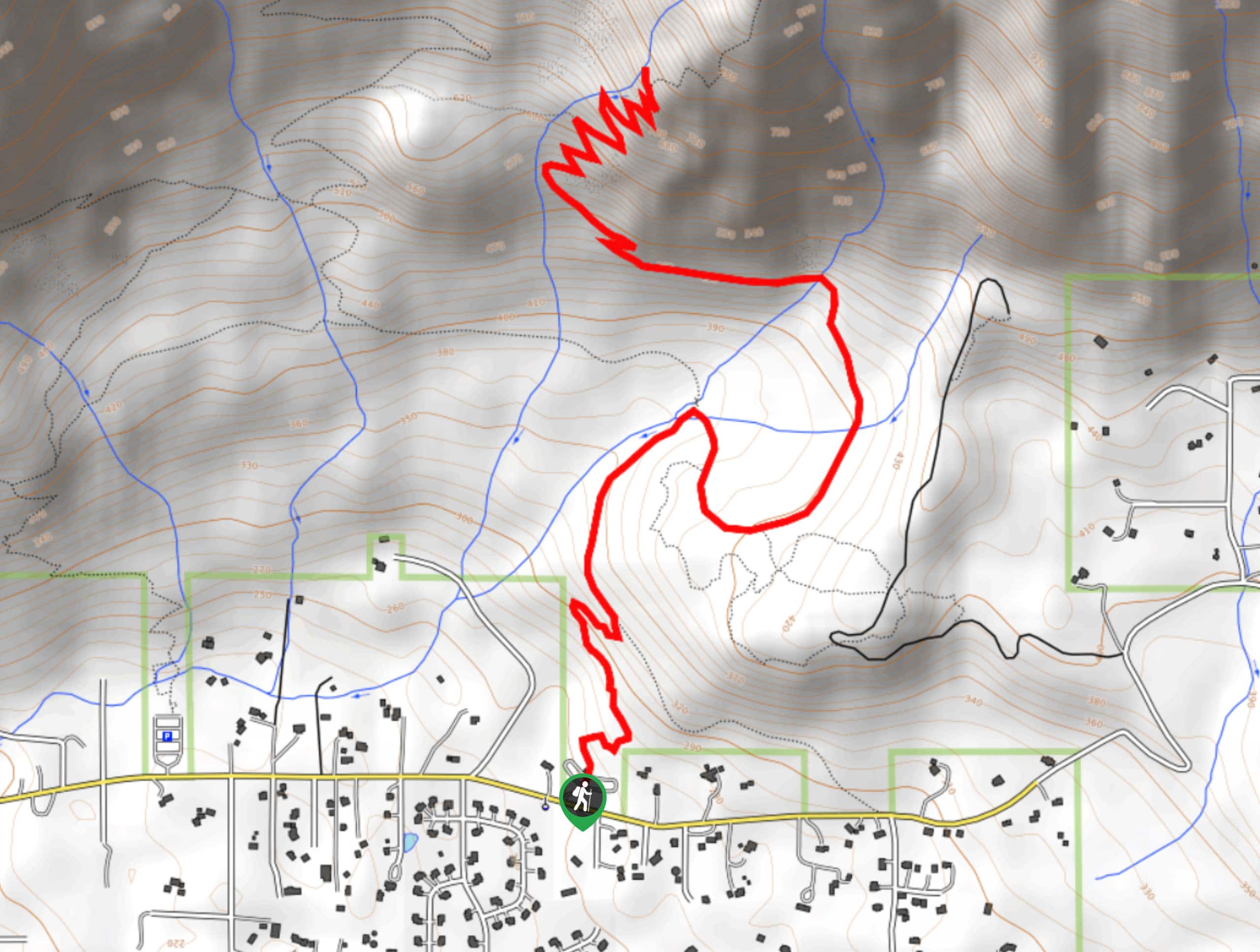
The trailhead for Mount Teneriffe Trail is off SE Mount Si Road. There is a turnoff into the parking area between 470th Ave SE and 473rd Ave SE.

About
| Backcountry Campground | No |
| When to do | May-October |
| Pets allowed | Yes - On Leash |
| Family friendly | Older Children only |
| Route Signage | Poor |
| Crowd Levels | High |
| Route Type | Out and back |
Teneriffe Falls via Mount Teneriffe Trail
Elevation Graph
Weather
Teneriffe Falls via Mount Teneriffe Trail Description
Teneriffe Falls via Mount Teneriffe Trail is a rewarding trip through a cool, misty forest to dripping falls with mountain views. Hikers will share the trail with others bound for the summit of Mount Teneriffe, so the hike can get a bit congested. Visiting in the early morning or during the week can minimize traffic. The first half of the trail is easy to follow and well-maintained, but the second half gets a bit rocky and some hikers report losing the trail. GPS and good boots will help you get the most out of this hike.
The falls don’t always have water flowing over them. Try to do this hike in the late spring for the best chance of a real waterfall experience, as they may dry up in hotter summers.
The hike begins from the parking area. Head north on Mount Teneriffe Trail, which is initially well-maintained. Sneak peeks of the mountains through the trees as you go. The elevation is consistent and moderate as you cruise around two wide switchbacks, then straighten out to follow a creek.
Where the creek splits into two arms, go right onto Teneriffe Falls Trail as Mount Teneriffe Trail splits off to the left. There are two junctions up next, and you’ll stay left at both.
Cross the stream twice before the trail flattens out a bit before switchbacking towards the falls. This is rocky and steeper, so take your time Avoid the Teneriffe Falls Connector to your left at the 5th switchback.
Reaching the falls, catch your breath and enjoy the flowing water. From here you’ll turn around and retrace your steps back to the parking lot.
Similar hikes to the Teneriffe Falls via Mount Teneriffe Trail hike

Lakes Dorothy, Bear, Deer, and Snoqualmie Hike
The Lakes Dorothy, Bear, Deer, and Snoqualmie Hike provides access to Lake Dorothy, Bear Lake, Deer Lake, and Snoqualmie Lake.…

Gold Creek Trail to Joe Lake
Gold Creek Trail to Joe Lake is not a hike for the faint of heart. This lightly trafficked trail is…

Basin Lake via Bullion Basin Trail
Basin Lake via Bullion Basin Trail is a 12.2mi hike that, with 2900ft of elevation gain,…
Comments