
Scout Patrol Peak
View Photos
Scout Patrol Peak
Difficulty Rating:
Scout Patrol Peak is a trail that you can hike in all seasons, and it offers some solitude no matter the time of year. The hike isn’t too long and involves less than a low elevation gain, making it a moderate trip. From the viewpoint, you’ll be able to see Granite Mountain, Humpback Mountain, and more. There is some scrambling required on this hike.
There are some bigger potholes on the road in so drive carefully.
Getting there
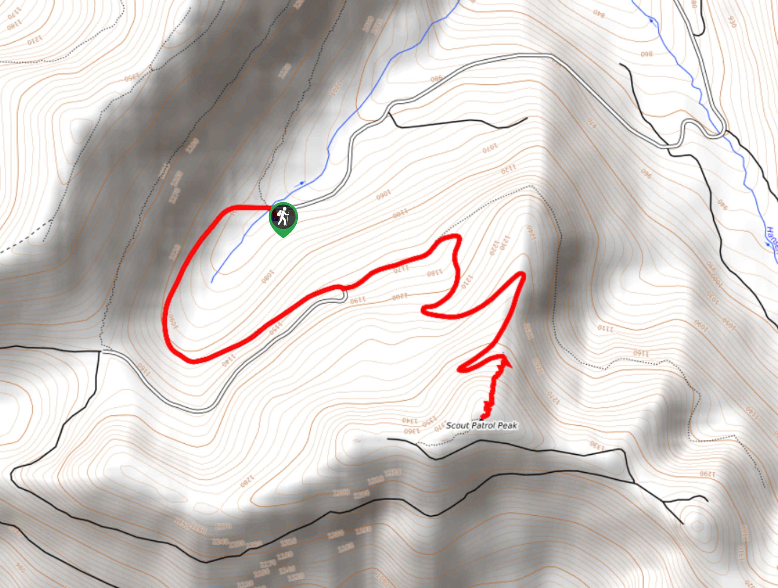
The trailhead for Scout Patrol Peak is at the end of National Forest Development Road 5510.

About
| Backcountry Campground | No |
| When to do | Year-round |
| Pets allowed | Yes - On Leash |
| Family friendly | Older Children only |
| Route Signage | Average |
| Crowd Levels | Low |
| Route Type | Out and back |
Scout Patrol Peak
Elevation Graph
Weather
Scout Patrol Peak Trail Description
There are memorable mountain views to be seen from Scout Patrol Peak, and this all-season trail often has very few hikers on it. There is a little bit of a scramble to the top, but it’s nothing too precarious.
The hike begins from the trailhead parking area. If you come in the winter, you may have to hike in further from the gate closure on the road. The trail wraps in a wide arc to the east on an old logging road. You’ll reach a junction with an abandoned forest road, and you’ll stay right here.
A handful of wide switchbacks lead you up to the peak, making the elevation gain fairly manageable. When you reach the base of the rock field, you’ll find that it’s quite a stable scramble without any significant challenges.
Enjoy the views from the peak before retracing your steps back to the trailhead.
Similar hikes to the Scout Patrol Peak hike

Lakes Dorothy, Bear, Deer, and Snoqualmie Hike
The Lakes Dorothy, Bear, Deer, and Snoqualmie Hike provides access to Lake Dorothy, Bear Lake, Deer Lake, and Snoqualmie Lake.…

Gold Creek Trail to Joe Lake
Gold Creek Trail to Joe Lake is not a hike for the faint of heart. This lightly trafficked trail is…

Basin Lake via Bullion Basin Trail
Basin Lake via Bullion Basin Trail is a 12.2mi hike that, with 2900ft of elevation gain,…
Comments