Mount Washington Hike
View Photos
Mount Washington Hike
Difficulty Rating:
The hike to the summit of Mount Washington is a 9.0mi moderately trafficked out-and-back trail in Olallie State Park that is rated as hard. This trail is not a hugely popular choice, so it enjoys much less traffic on the weekends despite its proximity to Seattle. Truthfully, some hikers enjoy this trail and some find the payoff underwhelming for the condition of the trail, which can be overgrown and rocky and isn’t well-signed. While the summit experience on other nearby mountains might be better, this is still a good experience and a refreshing break from the heavily trafficked trails nearby.
Getting there
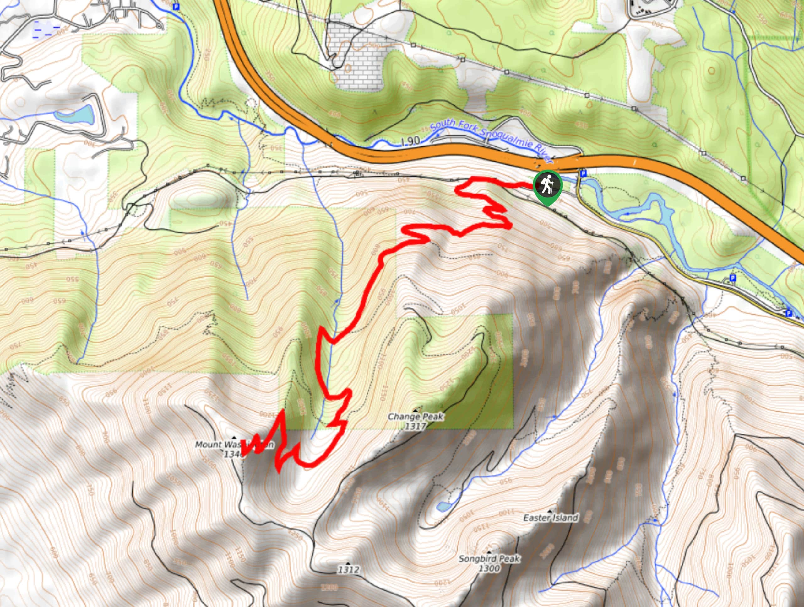
The trailhead for the Mount Washington summit trail is at the Homestead Valley Trailhead off I-90 south of the intersection with SE Homestead Valley Road.

About
| Backcountry Campground | No |
| When to do | May-October |
| Pets allowed | Yes - On Leash |
| Family friendly | Older Children only |
| Route Signage | Poor |
| Crowd Levels | Moderate |
| Route Type | Out and back |
Mount Washington Hike
Elevation Graph
Weather
Mount Washington Hike Description
The hike up to Mount Washington’s summit has pros and cons. The pros are that it’s less busy than other similar trails in the area, it’s close to Seattle, and it offers a nice peek of Mount Rainier. The cons are that it’s poorly signed, overgrown, and the summit area itself is quite small. We also recommend downloading a GPS track to help keep you on the trail. Do the hike and decide for yourself how you feel about it!
The trail begins from the Homestead Valley Trailhead. Stay left at the first junction with Palouse to Cascades State Park Trail to head uphill onto Mount Washington Trail. There are a few viewpoints at the beginning of the trail, including the Semi Wall and a cave. There is a spur trail to the Salal Point viewpoint to your left, you can either stay straight or make this short side trip.
The trail evens out for a while, then crosses a creek twice. When you cross Olallie Trail, look for Mount Washington Trail continuing just a bit to the left. You’ll begin some wide switchbacking turns, gaining elevation as you approach the summit. This section is tiring and rocky, but just keep going.
At the summit, look for Rainier in the distance. You’ll then retrace your steps, taking care over the rocky, steep sections and minding your way at the junctions, which could benefit from more signage. Until then, rely on your GPS to return to the trailhead.
Similar hikes to the Mount Washington Hike hike

Lakes Dorothy, Bear, Deer, and Snoqualmie Hike
The Lakes Dorothy, Bear, Deer, and Snoqualmie Hike provides access to Lake Dorothy, Bear Lake, Deer Lake, and Snoqualmie Lake.…

Gold Creek Trail to Joe Lake
Gold Creek Trail to Joe Lake is not a hike for the faint of heart. This lightly trafficked trail is…

Basin Lake via Bullion Basin Trail
Basin Lake via Bullion Basin Trail is a 12.2mi hike that, with 2900ft of elevation gain,…
Comments