
Bennettville Trail
View Photos
Bennettville Trail
Difficulty Rating:
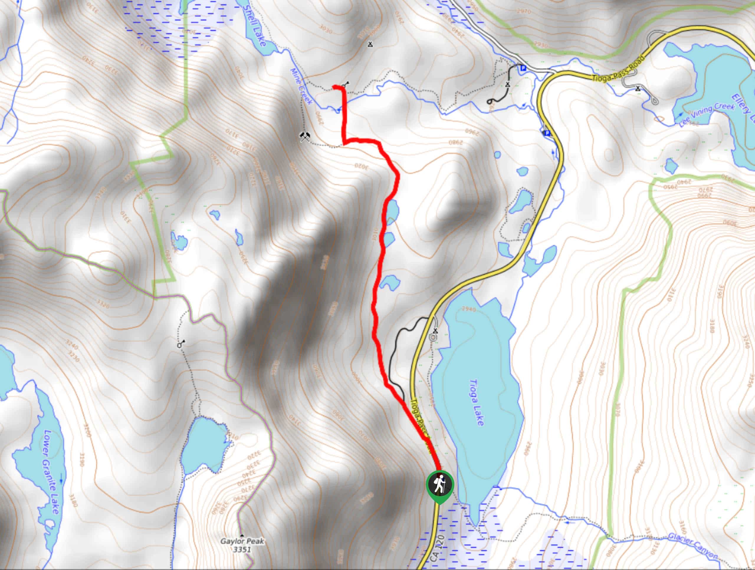
The Bennettville Trail is an easily accessible, family-friendly route within Inyo National Forest. The route takes you alongside charming creeks and picturesque lakes as it meanders through the imposing alpine environment of the eastern Sierra Nevada Mountain range.
Getting there
The trailhead for Bennettville Trail is located off of Tioga Pass Road.

About
| Backcountry Campground | |
| When to do | June-October |
| Pets allowed | Yes - On Leash |
| Family friendly | Yes |
| Route Signage | Average |
| Crowd Levels | Low |
| Route Type | Out and back |
Bennettville Trail
Elevation Graph
Weather
Bennettville Trail Description
One main thing to know before taking on the family-friendly Bennettville Trail is that the mosquitoes swarm in numbers during spring. To avoid the discomfort caused by the pesky bugs, we recommend bringing lots of bug spray, and wearing both long sleeves and pants. Likewise, a good pair of hiking shoes are also recommended as sections of the trail are over uneven terrain.
Having arrived at the trailhead, follow the Bennettville Loop Trail as it makes its way northwest. Almost immediately you will reach a junction within the trail, where you are to stay on the Bennettville Loop Trail by following the westernmost pathway. The route will begin to veer northwards, inclining in elevation slightly as it goes.
The Bennettville Loop Trail will pass alongside the western shore of three lakes, before plateauing shortly, and heading west. The route will then veer sharply northwards, cross a creek and end at a picturesque vista just south of Shell Lake. Here, scenic views of the surrounding area can be enjoyed! Once you’re ready, backtrack your steps towards the trailhead and your waiting vehicle along Tioga Pass Road.
Similar hikes to the Bennettville Trail hike

Valentine Lake Trail
An underrated route within Inyo National Forest, Valentine Lake Trail is without a doubt worth the effort! Boasting sublime scenery…

Mountain View and 3S89 Road Loop
Mountain View and 3S89 Road Loop is a delightful route within Inyo National Forest. Leading you through a lovely forested…
Dinosaur Falls Trail
Dinosaur Falls Trail is a beautiful route within Inyo National Forest. Easily accessible, the route is ideal for families with…
Comments