
Red Deer Lake Trail
View Photos
Red Deer Lake Trail
Difficulty Rating:
Discover one of the Indian Peak Wilderness’s hidden treasures. The Deer Lake Trail is a beautiful hike through verdant woodlands up to an idyllic alpine lake. From the lake, enjoy views of Sawtooth Mountain and Saint Vrain Mountain. Nestled among craggy peaks in a river valley, this isolated lake is like no other.
Getting there
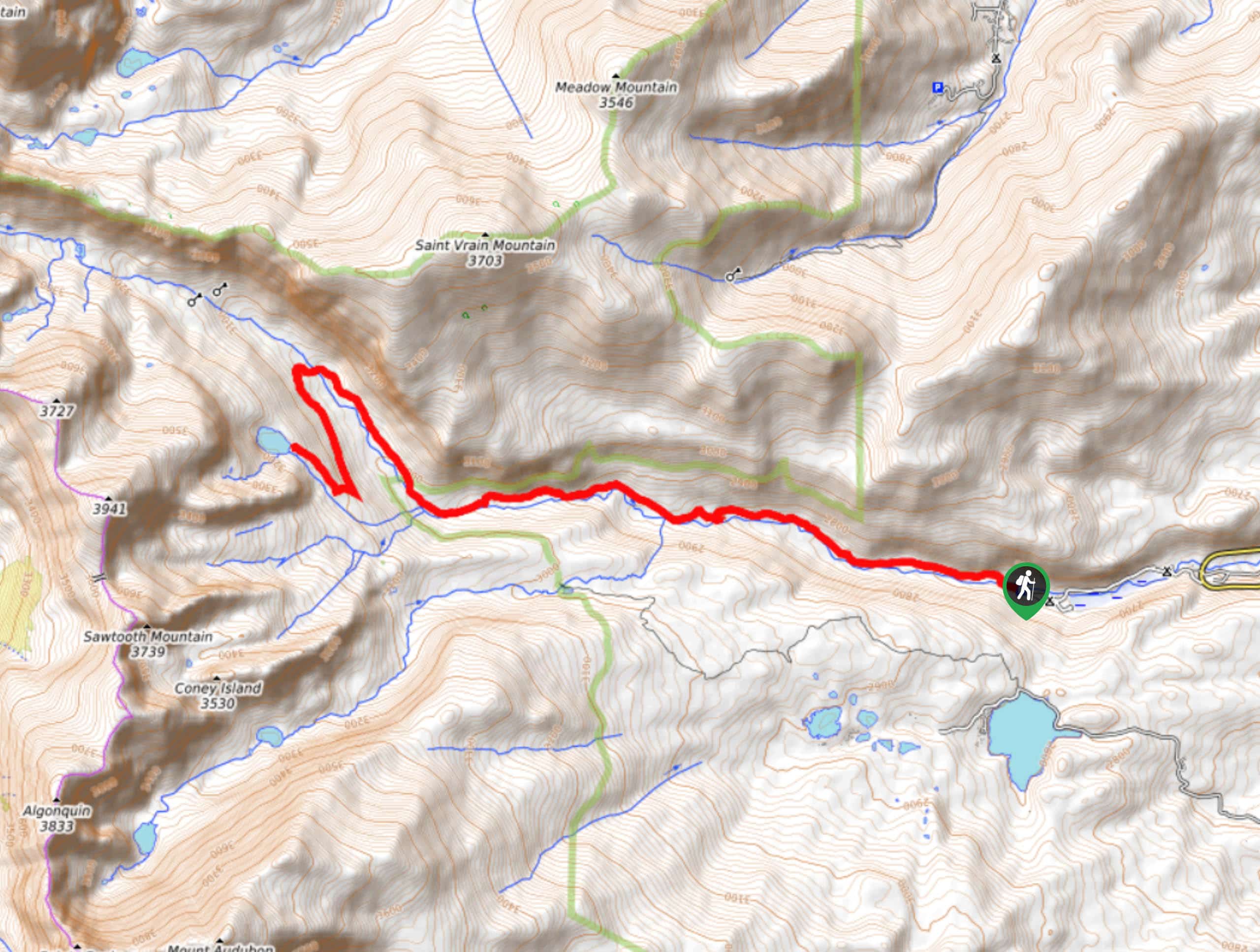
The Red Deer Lake Trail departs from the Camp Dick Campground off Country Road 92.

About
| Backcountry Campground | Yes, permits required. |
| When to do | June-September |
| Pets allowed | Yes - On Leash |
| Family friendly | Older Children only |
| Route Signage | Average |
| Crowd Levels | Low |
| Route Type | Out and back |
Red Deer Lake Trail
Elevation Graph
Weather
Red Deer Lake Trail Description
Hikers will trek through alpine forests and along a river valley when they complete this hike. The Red Deer Lake Hike is a lengthy hike through the Indian Peaks Wilderness. With fairly mild terrains and gradual elevation gain, this trail is great for those looking for an undemanding hike to vistas of the craggy Indian Peaks. Though undemanding terrain wise, this adventure is long and progressively climbs in altitude—it will surely get your blood pumping. When traversing this trail be mindful of moose, they are often spotted along this hike.
Start the Red Deer Lake Hike from the Camp Dick Parking Lot. Head onto Country Road 92J before quickly veering right onto Buchanan Pass Trail. Buchanan Pass Trail is serene as it follows the curves of the Middle St. Vrain Creek and past cascading waterfalls and through the lush forest. This section of the trail is lengthy. Continue along the path as it ascends the treeline. As the hike progresses you will meet a junction with the Saint Vrain Mountain Trail, stay left on Buchanan Pass Trail. Continue north along the path as it begins to curve. Avoid branching off the trail and stay left as it winds south. Hike along the path until you meet the trail signposted “Deer Lake”. Turn right and ascend the path to Deer Lake, sights of the surrounding craggy peaks await you.
After basking in the alpine scenery, retrace your steps. Maintain along the Buchanan Pass Trail for the entirety of your descent until you merge with Country Road 92J just prior to the carpark.
Similar hikes to the Red Deer Lake Trail hike

Caribou Pass Hike
The Caribou Pass Trail scales the west side of the Continental Divide. This short but steep hike will get your…

Buchanan Pass Loop
The Buchanan Pass Loop is an awesome adventure trail. Adults and kids alike will enjoy this wildflower-speckled trail as it…

Beaver Creek Trail
Beaver Creek Trail is a great wooded hike through the Colorado wilderness. With picturesque babbling brooks and past vast wildflower…
Comments