Mount Jasper Hike
View Photos
Mount Jasper Hike
Difficulty Rating:
The Mount Jasper Hike is a great excursion for those who don’t mind going off the beaten path. The majority of this hike is through an unmarked trail. Hikers will have to bring their compass and trail GPS for this one! Hike through the dense alpine woodlands, over the ridge and past Xanadu Lake before commencing your ascent to Mount Jasper’s summit.
Getting there
The Mount Jasper Hike departs from the Fourth Of July Trailhead off the Fourth of July Road.

About
| Backcountry Campground | Yes, permits required. |
| When to do | June-September |
| Pets allowed | Yes - On Leash |
| Family friendly | No |
| Route Signage | Poor |
| Crowd Levels | Moderate |
| Route Type | Out and back |
Mount Jasper Hike
Elevation Graph
Weather
Mount Jasper Hike Description
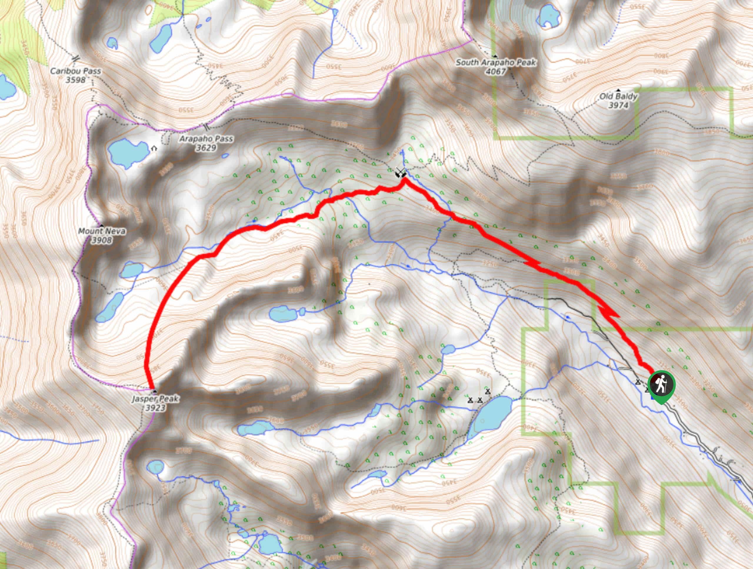
Mount Jasper Hike is a challenging hike up the Colorado Front Ranges to Mount Jasper. Mount Jasper sits at 12871ft elevation along the Continental Divide. Hikers who adventure the Mount Jasper trail need to be prepared for a bit of off-roading. This hike follows along a marked path until you have to veer off and ridge Mount Jasper. Use a GPS and compass to aid in your navigation up to the peak. On the south side of the ridge, you will see Xanadu Lake. Divert off the trail and explore the shore of the lake where you will find remnants from an old plane crash. Make sure you prepare for this hike before you begin navigating through the unmarked Colorado territory.
Begin this hike from the Fourth of July Trailhead and take the Arapaho Pass Trail. Hike this trail through the woodlands as you gradually gain elevation. As you top the timberline you will encounter the junction. Here you will see the Fourth of July Mine. Veer left on an unmarked path, heading west. Continue along the unofficial trail as it intersects with North Forth Middle Boulder Creek. Stay close to the creek and ensure to pass by two alpine lakes before you head south and climb the Mount Jasper Ridge. As you ascend the ridge you will have to navigate a scree. Continue up the ridge towards the peak. At this point you may have to scramble up the rocky field before you reach the summit. From Mount Jasper’s peak you will get awe-inspiring views of the Arapaho Peaks and Mount Neva. Below, you will see Xanadu Lake. Descend to the lake and explore the rusted remnants of the plane crash on its western shore.
When you go to return, either climb back to the summit of Mount Jasper or head north over the ridge. Make sure you return to the two alpine lakes before heading east, retracing your steps along the unmarked path. When you eventually arrive back at the junction, veer right onto Arapaho Pass Trail and hike southeast back to the parking lot.
Similar hikes to the Mount Jasper Hike hike

Caribou Pass Hike
The Caribou Pass Trail scales the west side of the Continental Divide. This short but steep hike will get your…

Beaver Creek Trail
Beaver Creek Trail is a great wooded hike through the Colorado wilderness. With picturesque babbling brooks and past vast wildflower…
Beaver Reservoir to Monarch Lake Hike
Beaver Reservoir to Monarch Lake Hike is a one-way trail in the Indian Peaks Wilderness. We love this hike because…
Comments