
Beaver Reservoir to Monarch Lake Hike
View Photos
Beaver Reservoir to Monarch Lake Hike
Difficulty Rating:
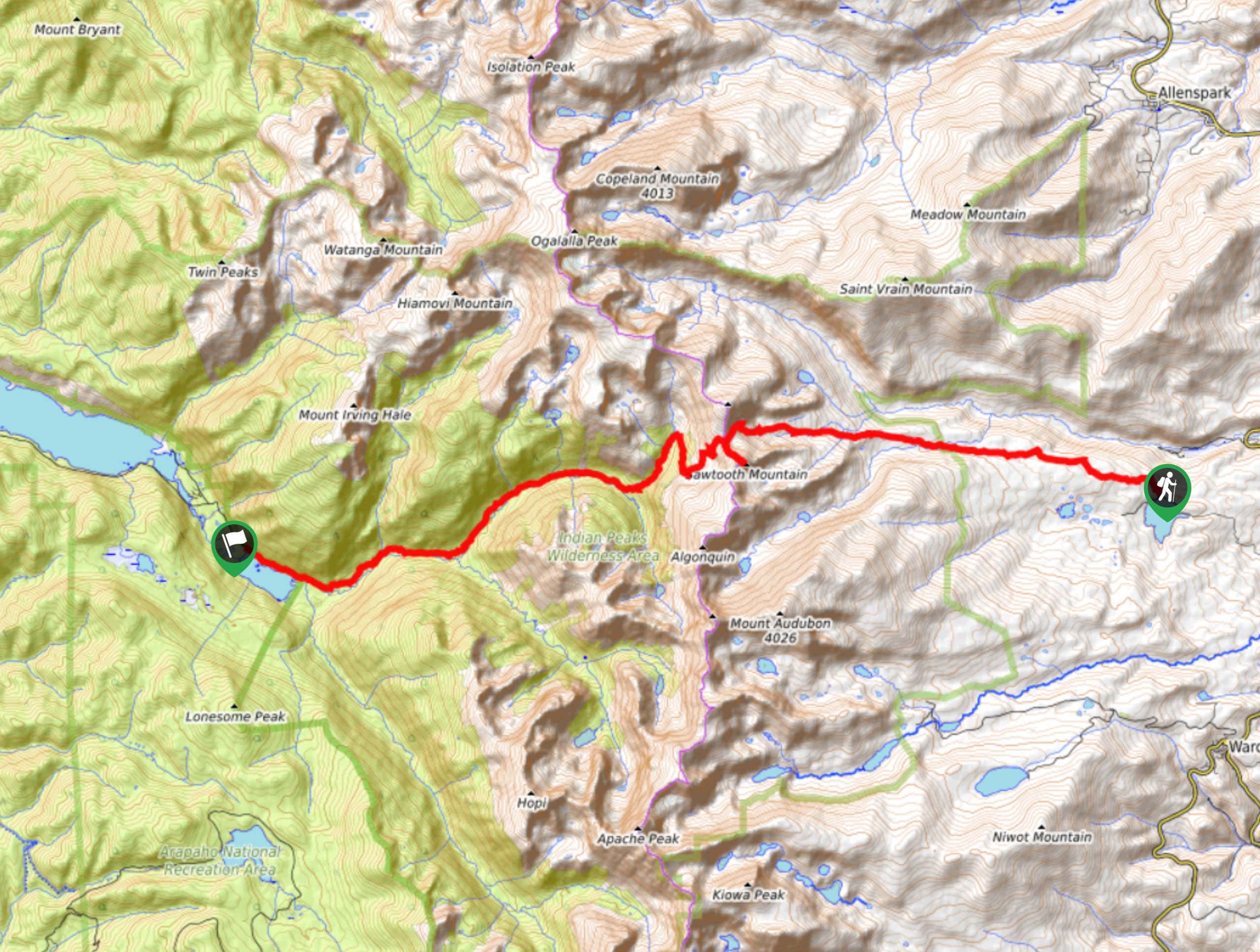
Beaver Reservoir to Monarch Lake Hike is a one-way trail in the Indian Peaks Wilderness. We love this hike because you aren’t retracing your steps back to the carpark. Instead, this hike will guide you through various Colorado terrains and up and over the Continental Divide. This hike is not for the faint of heart, but if you are seeking a stimulating excursion through the Indian Peaks, then you have found your next adventure.
Getting there
The Beaver Reservoir to Monarch Lake Trail departs from the Beaver Reservoir Parking Lot off of Country Road 96.

About
| Backcountry Campground | Yes, permits required. |
| When to do | April-October |
| Pets allowed | Yes - On Leash |
| Family friendly | No |
| Route Signage | Poor |
| Crowd Levels | Moderate |
| Route Type | One Way |
Beaver Reservoir to Monarch Lake Hike
Elevation Graph
Weather
Beaver Reservoir to Monarch Lake Hike Description
The Beaver Reservoir to Monarch Lake Trail is an exhilarating hike. Navigate through primitive trails, scale Sawtooth Mountain and the Continental Divide all in one day. Make sure you grab your trail GPS prior to heading out because the hike traverses through some underdeveloped areas. Don’t fret though, we’ve got you! Additionally, make sure you are adequately experienced before conquering this trail, you will need to scramble up steep rock taluses, navigate switchbacks and be comfortable hiking off the beaten path. Don’t forget to leave a car at the finish line!
Begin this trail at the Beaver Reservoir Parking Lot. From here, hook onto Coney Creek Road. Hike Coney Creek Road for a while before crossing a bridge. After the bridge, veer left onto the Beaver Creek Trail. Follow this trail through the woodlands as you gradually gain elevation. Stay on this path as it merges onto Buchanan Pass Trail, stay left here. At this point, you will ascend the treeline and begin your climb up to Buchanan Pass. This segment of the trail is rocky and steep. Be careful when scrambling up the ridge. Navigate the rocky switchbacks until you summit the Continental Divide.
Once on the pass, feel free to hike the steep, but short climb up to Sawtooth Mountain peak. Here you will be rewarded with expanse vistas of the Indian Peaks Wilderness. Head back down the summit to Buchanan Pass. Descend the west side of the pass, maneuvering loose boulders and the rocky scree. Continue along Buchanan Pass Trail as you dip back below the tree line. Do your best to stay on this trail. Eventually you will encounter a junction with the Cascade Creek Trail, take this path west as it guides you down to Monarch Lake and to the Parking lot.
Similar hikes to the Beaver Reservoir to Monarch Lake Hike hike

Caribou Pass Hike
The Caribou Pass Trail scales the west side of the Continental Divide. This short but steep hike will get your…

Beaver Creek Trail
Beaver Creek Trail is a great wooded hike through the Colorado wilderness. With picturesque babbling brooks and past vast wildflower…
Caribou District Peaks Hike
Caribou District Peaks Hike is a rough, unmarked trail that summits six small mountains. Traversing rocky terrain and overgrown trails,…
Comments