Betty and Bob Lakes via High Lonesome Trail
View Photos
Betty and Bob Lakes via High Lonesome Trail
Difficulty Rating:
Betty and Bob Lakes via High Lonesome Trail is a short out-and-back trail to three of the most scenic lakes nestled among the Indian Peaks. Usually, these lakes are accessed by much longer and challenging trails, but we’ve got a shortcut for you!
Getting there
Access the High Lonesome Trailhead at the end of Rollins Pass Road. Be aware that Rollins Pass Road is subject to seasonal closures.

About
| Backcountry Campground | Yes, permits required. |
| When to do | June-October |
| Pets allowed | Yes - On Leash |
| Family friendly | Yes |
| Route Signage | Average |
| Crowd Levels | Moderate |
| Route Type | Out and back |
Betty and Bob Lakes via High Lonesome Trail
Elevation Graph
Weather
Betty and Bob Lakes via High Lonesome Trail Description
Betty and Bob Lakes via High Lonesome Trail is a stunning mellow hike in the Indian Peaks Wilderness. The road going up to the trailhead is not so easy going through. Make sure you have a vehicle with high ground clearance and preferably four-wheel drive. When you do arrive at the trailhead, you will become instantly relaxed as you commence your hike through the green alpine forest to King Lake. That’s right, this trail doesn’t just guide you to Betty and Bob Lakes. Three gorgeous alpine lakes perfect for relaxing and fishing await you. Note that without tree coverage it can be a little chilly at the lakes, so bring layers!
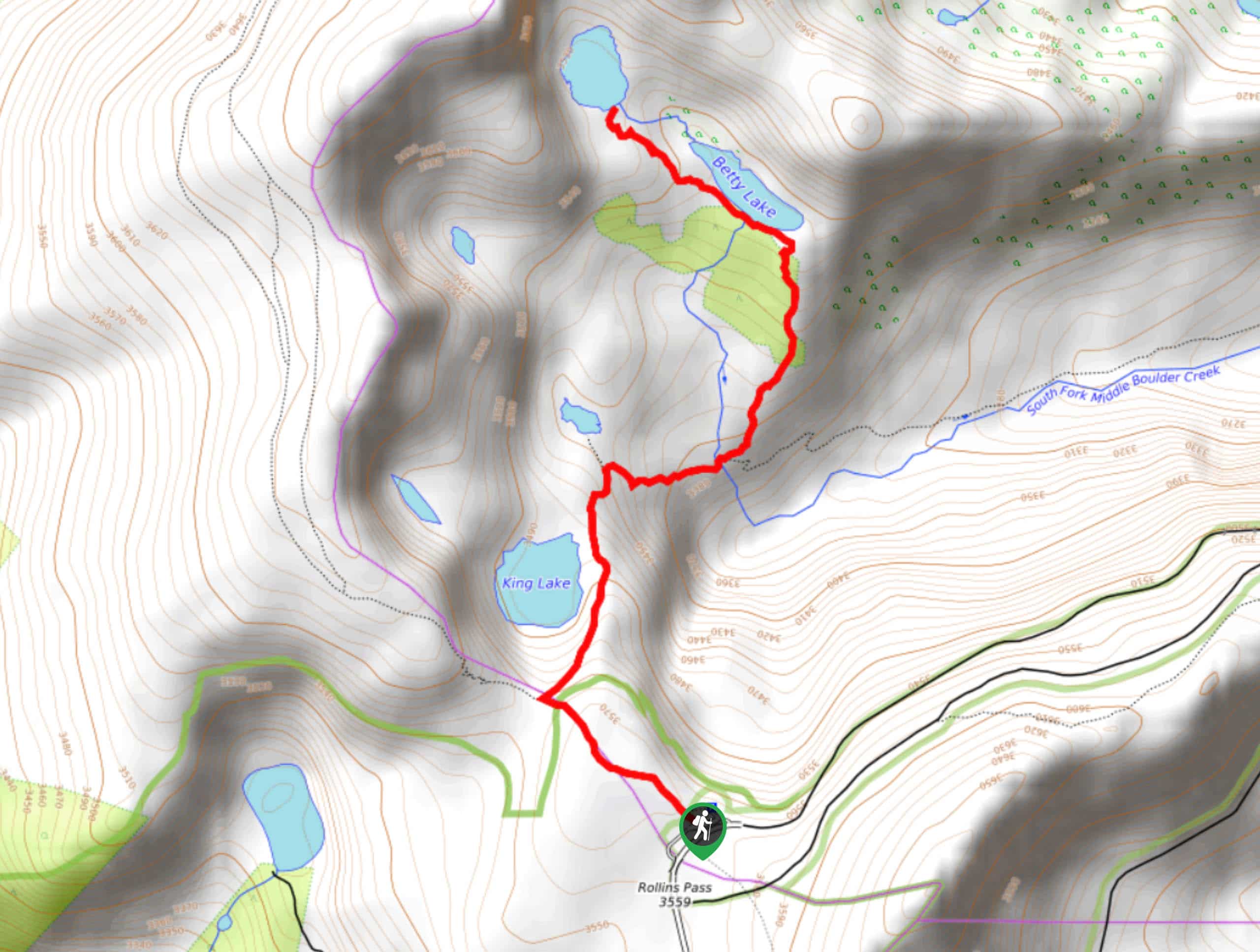
Begin this hike at the Rollins Pass Parking Lot. From the parking lot the Betty and Bob Lakes via High Lonesome Trail hike begins on the High Lonesome Trail. Head up the High Lonesome Trail and you will quickly meet an intersection. Turn right onto King Lake Trail. You will hike the ridge of the picturesque King Lake before descending down into a river valley. At the next junction, veer left onto Bob and Betty Lakes Trail. You will gradually ascend the treeline as you near the lakes. This section is a bit steep, but manageable. The first lake you will pass is Betty Lake and at the end of the trail you will find Bob Lake.
Enjoy the vistas of the lakes hemmed by Colorado’s craggy snow-dusted peaks before heading back. To get back to the carpark, retrace your steps.
Similar hikes to the Betty and Bob Lakes via High Lonesome Trail hike

Caribou Pass Hike
The Caribou Pass Trail scales the west side of the Continental Divide. This short but steep hike will get your…

Buchanan Pass Loop
The Buchanan Pass Loop is an awesome adventure trail. Adults and kids alike will enjoy this wildflower-speckled trail as it…

Beaver Creek Trail
Beaver Creek Trail is a great wooded hike through the Colorado wilderness. With picturesque babbling brooks and past vast wildflower…
Comments