
Caribou District Peaks Hike
View Photos
Caribou District Peaks Hike
Difficulty Rating:
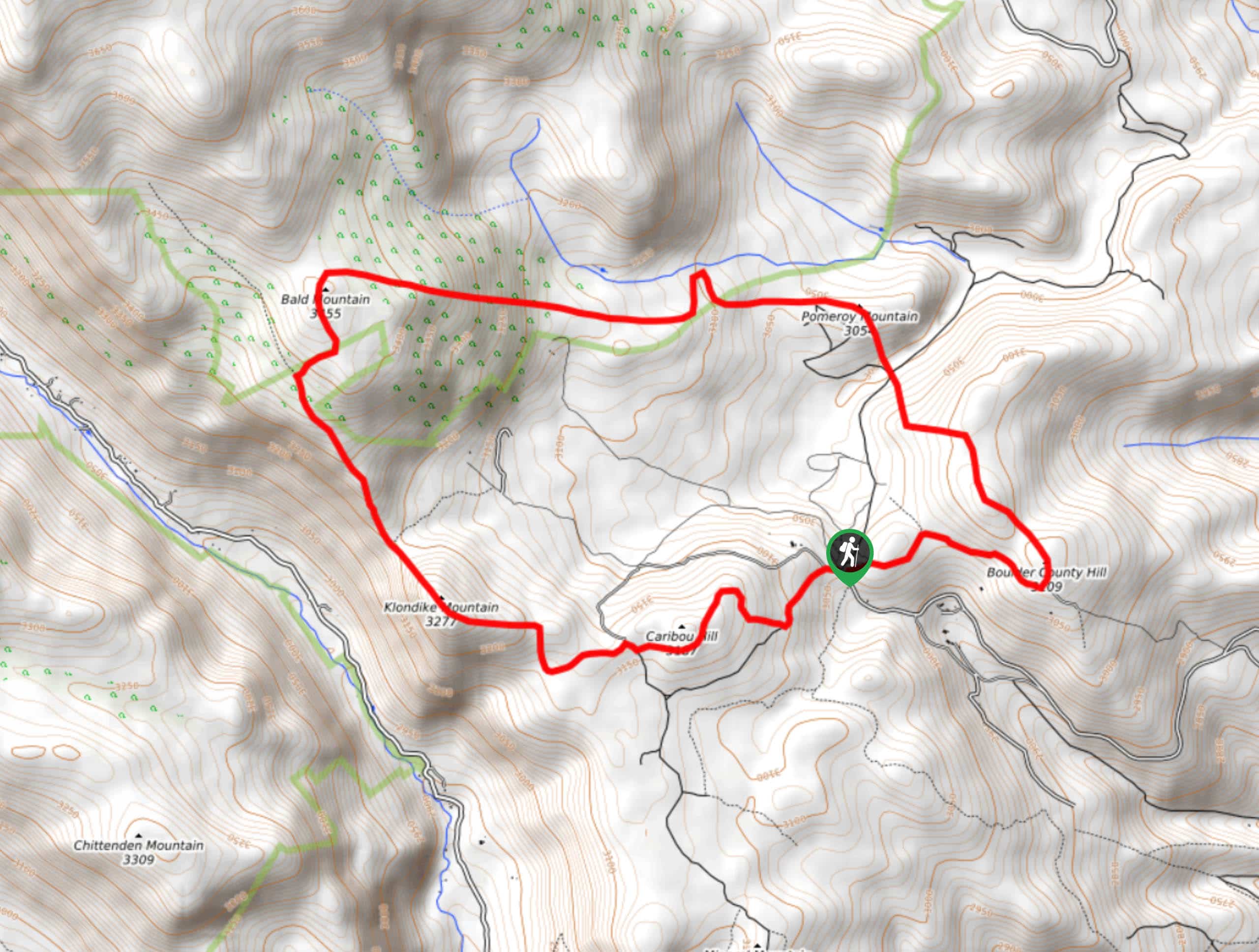
Caribou District Peaks Hike is a rough, unmarked trail that summits six small mountains. Traversing rocky terrain and overgrown trails, you will have to bushwhack for most of this hike. Though underdeveloped, this hike has a lot to offer. Hike through an old mining district where rusted remnants remain. This hike is anything but unexciting, so grab your GPS and head out.
Getting there
The Caribou Hill Trail is off the parking lot at the intersection of Caribou Road and Boulder Country Hill Road.

About
| Backcountry Campground | |
| When to do | June-October |
| Pets allowed | Yes - On Leash |
| Family friendly | Older Children only |
| Route Signage | None |
| Crowd Levels | Moderate |
| Route Type | Circuit |
Caribou District Peaks Hike
Elevation Graph
Weather
Caribou District Peaks Hike Description
If you are seeking an exciting adventure filled with twists and turns, then the Caribou District Peaks Hike will suit you well. This hike has something for everyone: lush meadows, woodlands, historic mine remnants and endless adventure. Just be sure to bring a trail GPS and wear pants because you will be on bushwhacking for much of this hike.
Begin the Caribou District Peaks Hike at the Caribou Hill Trailhead. From the trailhead, get onto Route 128J before veering right onto Klondike East Trail up to the summit of Caribou Hill. Descend the hill westward and hook onto Bald Mountain Spur Road. This road will guide you up to the peak of Klondike Mountain. Descend the northside of the mountain and navigate your way through the brush up to Bald Mountain. Climb down Bald Mountain on the east side and keep your eye out for mine remnants. Head East towards Pomeroy Mountain. Pass two mines on your southward descent. Continue following your GPS as you navigate your way to Soft Ranked Summit and Boulder County Hill.
At this point, you will finally meet a maintained trail again. Head west on Boulder County Hill Road until you arrive back at the parking lot.
Similar hikes to the Caribou District Peaks Hike hike

Caribou Pass Hike
The Caribou Pass Trail scales the west side of the Continental Divide. This short but steep hike will get your…

Buchanan Pass Loop
The Buchanan Pass Loop is an awesome adventure trail. Adults and kids alike will enjoy this wildflower-speckled trail as it…

Beaver Creek Trail
Beaver Creek Trail is a great wooded hike through the Colorado wilderness. With picturesque babbling brooks and past vast wildflower…
Comments