
Old Baldy Mountain Hike
View Photos
Old Baldy Mountain Hike
Difficulty Rating:
Old Baldy Mountain Hike. How could you not want to hike this trail with a name like that? The Old Baldy Mountain Hike is a challenging excursion up to the summit which has incredible views of neighboring cloud scraping peaks and the forested valleys below! The initial segment of the trail is usually quite busy, but when you turn off to summit the Mountain, you might just have the trail all to yourself.
Getting there
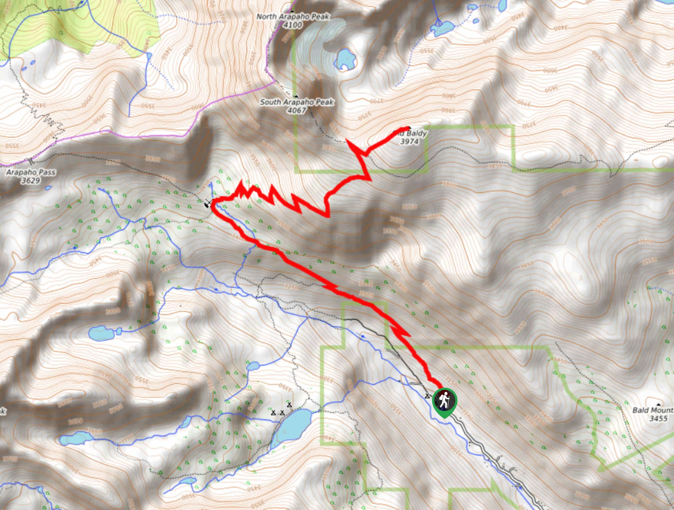
The Old Baldy Mountain Hike begins from the Fourth of July Trailhead at the end of the Fourth of July Road.

About
| Backcountry Campground | Yes, permits required. |
| When to do | June-September |
| Pets allowed | Yes - On Leash |
| Family friendly | No |
| Route Signage | Average |
| Crowd Levels | Moderate |
| Route Type | Out and back |
Old Baldy Mountain Hike
Elevation Graph
Weather
Old Baldy Mountain Hike Description
The Old Baldy Mountain Hike is a great workout. Constantly climbing in elevation, your legs will get tired. Totally worth the effort though! The trail is rugged and exposed as you ascend the peak, wear hiking boots and bring layers for the summit! Challenging and steep in places, you’ll want to pack plenty of water or a water filter. There are plenty of streams and water pools along the way to filter! On your next trip to the Colorado Wilderness consider hiking up Old Baldy, you won’t be disappointed.
Begin this trail at the Fourth of July Trailhead. Parking is limited, so arrive early to get a spot! Take the Arapaho Pass Trail and it will guide you northwest through the lush aspen forest. Along this trail, you will be gradually climbing, keep your eye out for cascading waterfalls off the path. At the first intersection, stay right on the Arapaho Pass Trail. Continue hiking this path as you surmount the timberline and meet another junction. Here, you will see old remnants of the Fourth of July Mine. Bear right onto the Arapaho Glacier Trail. At this point, the terrain will become increasingly rocky and technical as you ascend the saddle towards the peak. Navigate several switchbacks and meet another junction. Head northeast onto the Old Baldy Trail. This section of the trail is unmarked. Maneuver the steep talus field and watch your step as you hike up to the summit. Once you are at the summit, you will have an expansive view of the Indian Peaks Wilderness.
Explore Old Baldy Mountain and revel in the up-close and personal view of Arapaho peaks before beginning your descent. Carefully retrace your steps down the mountain ridge before hooking back onto the Arapaho Glacier Trail. Follow this trail and retrace your steps back to the Arapaho Pass Trail which will deliver you back to the parking lot.
Similar hikes to the Old Baldy Mountain Hike hike

Caribou Pass Hike
The Caribou Pass Trail scales the west side of the Continental Divide. This short but steep hike will get your…

Beaver Creek Trail
Beaver Creek Trail is a great wooded hike through the Colorado wilderness. With picturesque babbling brooks and past vast wildflower…
Beaver Reservoir to Monarch Lake Hike
Beaver Reservoir to Monarch Lake Hike is a one-way trail in the Indian Peaks Wilderness. We love this hike because…
Comments