Caribou Hill Trail
View Photos
Caribou Hill Trail
Difficulty Rating:
The Caribou Trail is a perfect adventure for the whole family. Walk through vast meadows dotted with stunning wildflowers before ascending Caribou Hill. Though small compared to the Indian Peaks, Caribou Hill still delivers some stunning views of the Colorado Mountain Ranges and the meadowed landscape. Continue to the Klondike Ridge if you are feeling adventurous. This trail is manageable for hikers of all skill levels. Get ready and head out to the Caribou Hill Trail.
Getting there
The Caribou Hill Trail is off the parking lot at the intersection of Caribou Road and Boulder Country Hill Road.

About
| Backcountry Campground | Yes, Caribou Townsite |
| When to do | June-October |
| Pets allowed | Yes - On Leash |
| Family friendly | Yes |
| Route Signage | Poor |
| Crowd Levels | Moderate |
| Route Type | Lollipop |
Caribou Hill Trail
Elevation Graph
Weather
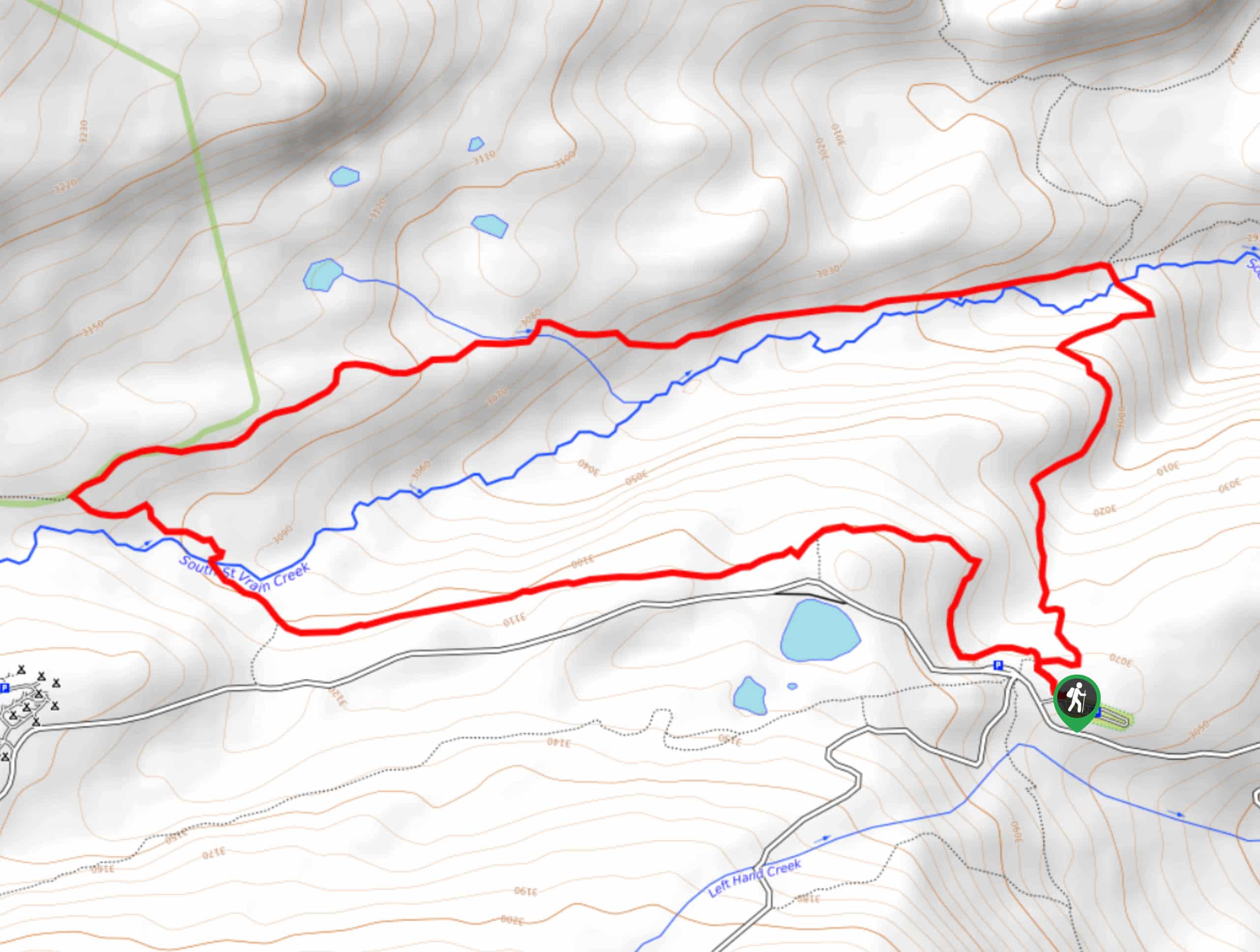
Caribou Hill Trail Description
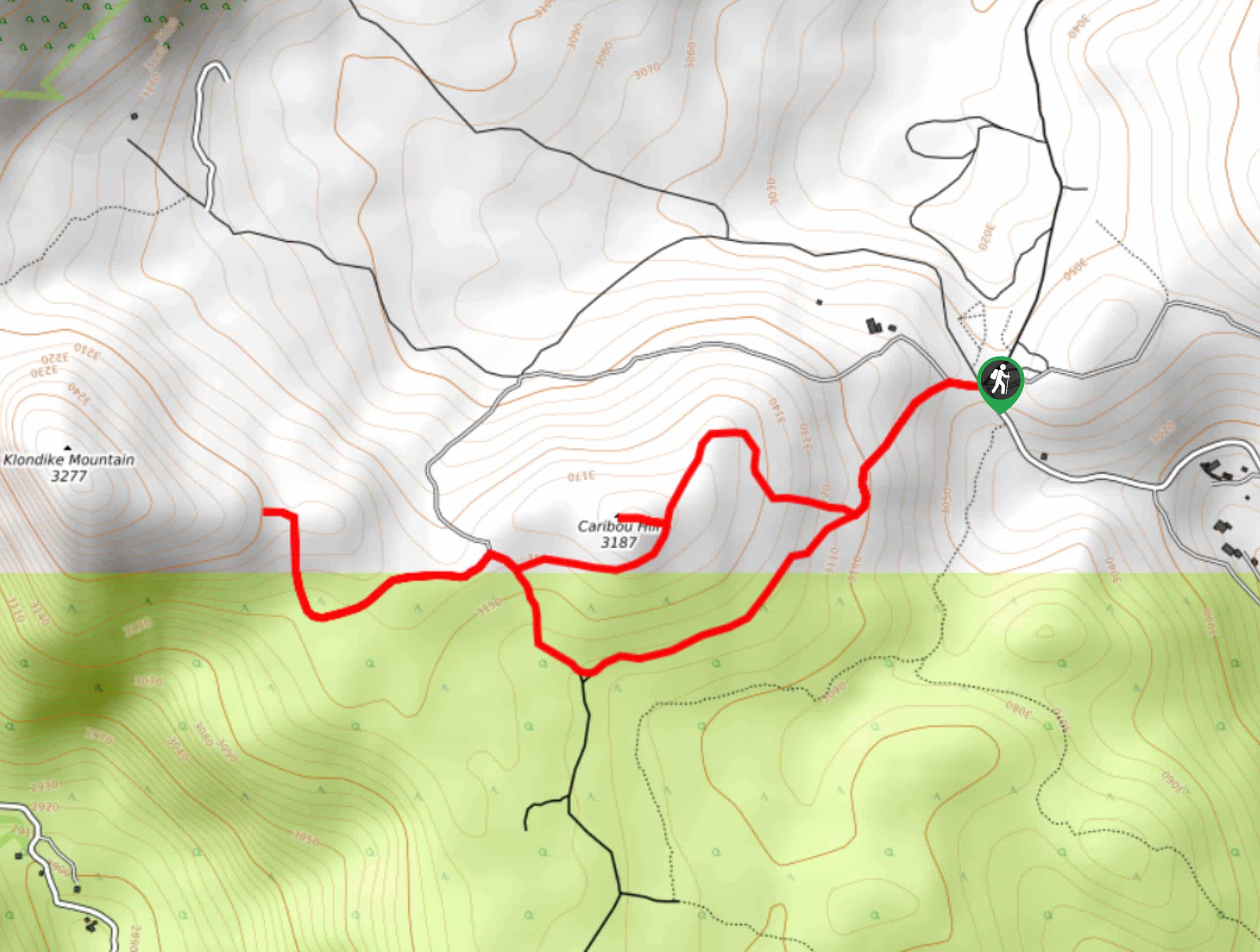
The Caribou Hill Trail follows along a dirt road before veering off to ascend the Hill. Though the trail has little elevation gain, the hike up the hill will get your blood pumping. Unfortunately, this trail is not well marked, but don’t worry, we’ve got you. Make sure to use the trail GPS when navigating this hike.
Begin this hike from the Caribou Hill parking lot at the Caribou Townsite. The trail begins behind the steel gate. We recommend completing this loop counterclockwise. Take Route 128J until you meet an intersection. Bear right onto Klondike East Trial. Continue on this trail as it gradually climbs towards Caribou Hill. You will shortly ridge Caribou Hill. Feel free to hike up and explore before reconnecting on Klondike East Trail heading west. Here you will meet another junction. If you want to ascend the Klondike Ridge, then merge left onto Bald Mountain Spur Route. Continue on this trail until you summit the ridge.
Admire the views before beginning your descent. Retrace your steps back to the intersection and instead of returning on the Klondike East Trail, turn right and head south on Route 128J. At the next junction, stay left. This dirt road will guide you east through meadows before delivering you back to the parking lot.
Similar hikes to the Caribou Hill Trail hike

Buchanan Pass Loop
The Buchanan Pass Loop is an awesome adventure trail. Adults and kids alike will enjoy this wildflower-speckled trail as it…
Betty and Bob Lakes via High Lonesome Trail
Betty and Bob Lakes via High Lonesome Trail is a short out-and-back trail to three of the most scenic lakes…
Sourdough Trail via South St. Vrain Hike
Looking for a relaxing hike through the lush Colorado woodlands? The Sourdough Trail via South St. Vrain Hike is a…
Comments