Jean Lunning and Pawnee Pass Hike
View Photos
Jean Lunning and Pawnee Pass Hike
Difficulty Rating:
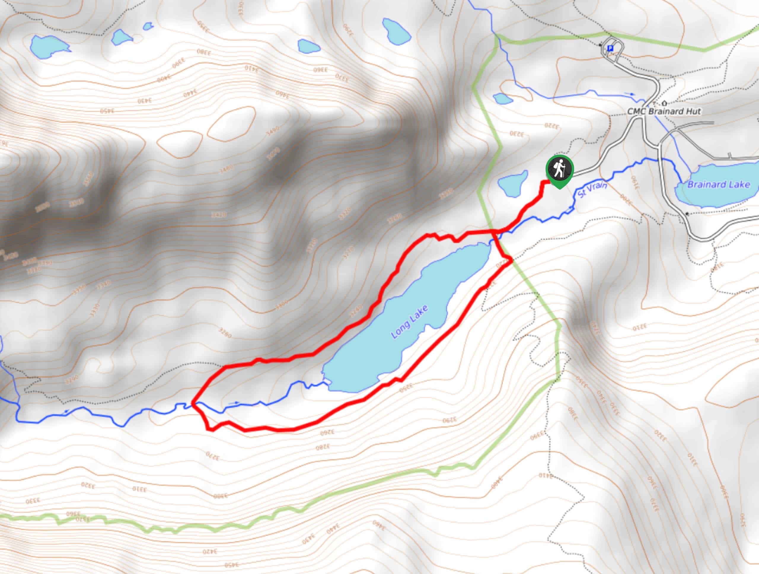
The Jean Lunning Trail and Pawnee Pass Hike is a beautiful trail in the Brainard Lake Recreational Area. This relaxed adventure is perfect for hikers of all skill levels! Walk along the shores of Long Lake and through meadows dotted with gorgeous wildflowers! Keep an eye out for deer and moose as they roam this area.
Getting there
The Jean Lunning Trail and Pawnee Pass Hike is located in the Brainard Lake Recreational Area. Visitors will require a parking permit which can be purchased online or on-site. The trailhead is located at the end of Long Lake Road.

About
| Backcountry Campground | |
| When to do | June-October |
| Pets allowed | Yes - On Leash |
| Family friendly | Yes |
| Route Signage | Average |
| Crowd Levels | High |
| Route Type | Lollipop |
Jean Lunning and Pawnee Pass Hike
Elevation Graph
Weather
The Jean Lunning Trail and Pawnee Pass Hike Description
The Jean Lunning Trail and Pawnee Pass Hike is suitable for families and great for those who desire a chill meander through the Indian Peaks Wilderness. Don’t be mistaken, though it is a fairly easy hike, you will still get some amazing sights of the Continental Divide and the Indian Peaks. Between November 15th and April 30th, dogs are prohibited on this trail. Note that the Brainard Lake Recreational Area and the Brainard Lake Road close in late-October until mid-June. Off-season visitors will have to park outside the Gateway and hike in.
Starting from the Long Lake Parking lot, head southwest on the Pawnee Pass Trail. At the intersection you can choose to complete this hike from either direction, but we recommend going clockwise. Veer left onto Jean Lunning Trail, taking you along the south side of Long Lake. Continue along this trail as it weaves you between the shoreline, meadows and lush forests. Stay on this route as it eventually begins to curve right along the west side of the lake. Here, you will get some amazing views of the Indian Peaks. Cross the footbridge and follow the trail as it guides you east. At this point, the path will merge onto Pawnee Pass Trail. Appreciate the meadows and dense alpine forests before returning to the shoreline.
Feel free to explore the shore, dipping your toes in the refreshing water before hooking back on to the trail. This final segment of the hike will deliver you back to the carpark.
Similar hikes to the Jean Lunning and Pawnee Pass Hike hike

Buchanan Pass Loop
The Buchanan Pass Loop is an awesome adventure trail. Adults and kids alike will enjoy this wildflower-speckled trail as it…
Betty and Bob Lakes via High Lonesome Trail
Betty and Bob Lakes via High Lonesome Trail is a short out-and-back trail to three of the most scenic lakes…
Sourdough Trail via South St. Vrain Hike
Looking for a relaxing hike through the lush Colorado woodlands? The Sourdough Trail via South St. Vrain Hike is a…
Comments