Isabelle Glacier Hike
View Photos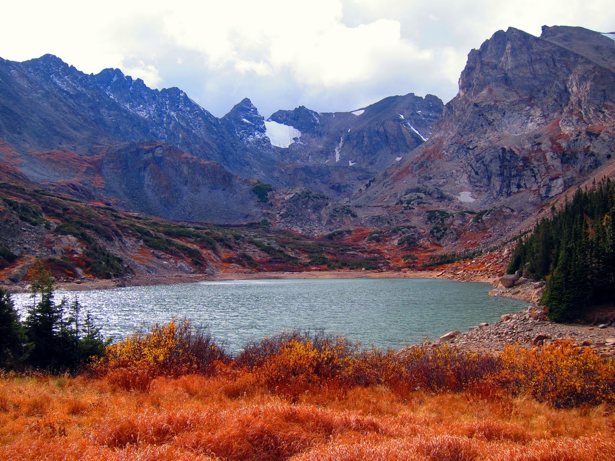
Isabelle Glacier Hike
Difficulty Rating:
If you are looking for a challenging but rewarding excursion, the Isabelle Glacier Hike is perfect. Though fairly demanding, the awe-inspiring vistas of the Indian Peaks as you summit the talus field will motivate even the most discouraged hikers. Saddled between the Shoshone and Apache Peaks, the Isabelle Glacier hike is jaw dropping and well worth the effort.
Getting there
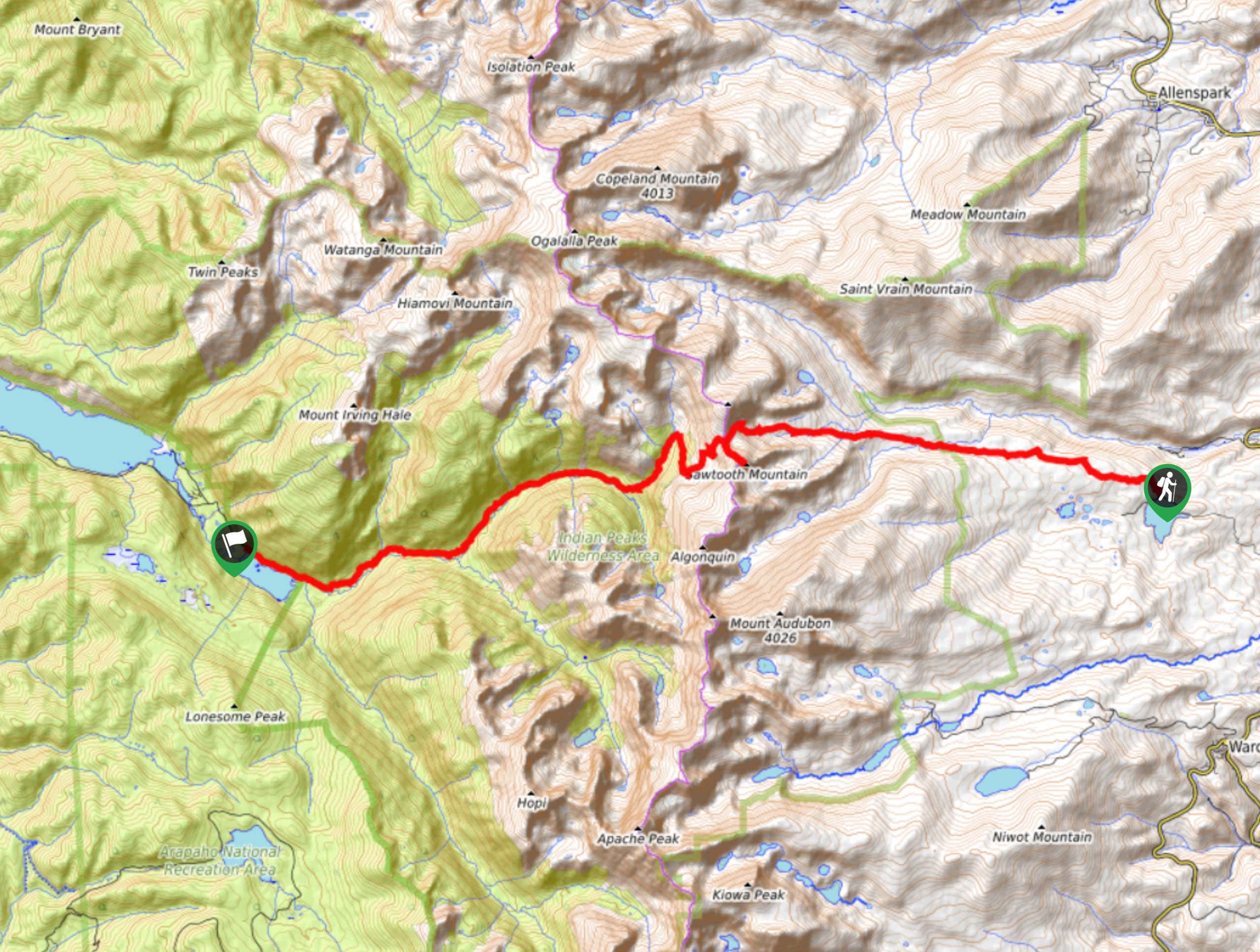
To get to the Isabelle Glacier Trail, head to the Brainard Lake Recreational Area.
The trailhead and car park are located at the end of Long Lake Road!

About
| Backcountry Campground | |
| When to do | June-October |
| Pets allowed | Yes - On Leash |
| Family friendly | Older Children only |
| Route Signage | Average |
| Crowd Levels | High |
| Route Type | Lollipop |
Isabelle Glacier Hike
Elevation Graph
Weather
Isabelle Glacier Hike Description
The Isabelle Glacier Hike starts out moderately undemanding, but as you venture towards the glacier it escalates quickly. As the trail gains elevation, the terrain becomes exceptionally rocky, and you will have to scramble a talus field before cresting the Isabelle Glacier. Wear sturdy footwear to avoid rolling an ankle! Microspikes and poles might also come in handy. Due to the extreme elevation of the glacier, prepare for inclement weather at the summit. Wear layers and check the forecast prior to setting out to avoid storms. The Isabelle Glacier Hike will stimulate your senses and get your blood pumping!
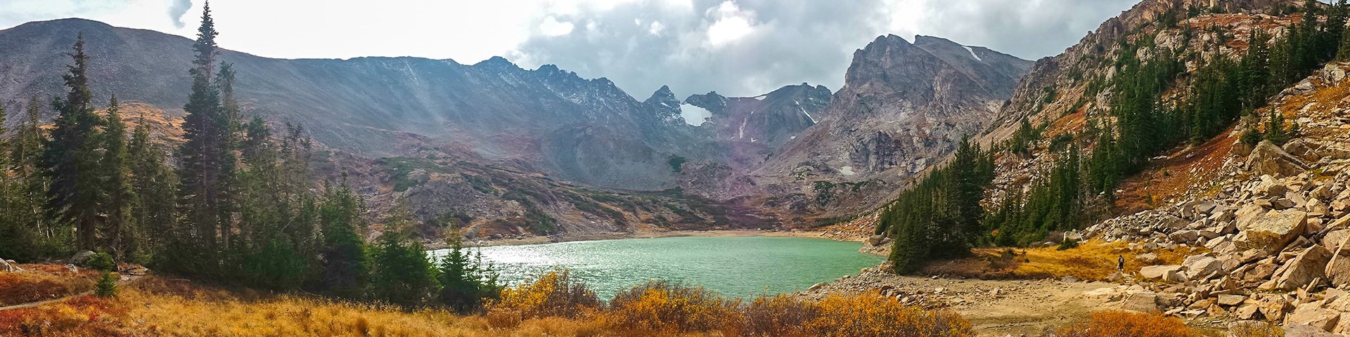
Add this hike to your adventure bucket-list! The Isabelle Glacier Trail is a one-of-a-kind hike in the Indian Peaks Wilderness. The panoramic view from the glacier of the peaks and landscape below are unlike no other. It is hard to enjoy the journey when you are so focused on the destination, but on this trail, make sure you do. You’ll want to savour every moment of the expedition as you travel through wooded terrain, past a remarkably blue alpine lake, and wildflower meadows all before opening up to stunning vistas of the snow dusted Indian Peaks.
Start this adventure from the Pawnee Pass Trailhead. Heading southeast, the trail will quickly border the shoreline of Long Lake. Continue east on Pawnee Pass trail for a few kilometers before you confront a junction. At this intersection veer left onto Isabelle Glacier Trail. Follow along the path as it hugs the side of the stunning Isabelle Lake which has breathtaking views of the encompassing craggy peaks. Take a break, dip your toes in the water and explore the shoreline!
After revelling in the beauty of Isabelle Lake, continue hiking. As you continue along this route, you will intersect with South St. Vrain Creek several times. There are numerous water sources along this hike, so consider bringing your water filter to lighten your load! Passing along creeks and meadows, the hike will become more exposed as you top the treeline. This is the final and steepest section of the trail.
At this point, the trail begins to rapidly gain elevation and the terrain becomes increasingly rocky. As you begin the ascent towards the glacier there are multiple switchbacks to navigate. Exercise caution and take it slow. After you conquer the tightly wound switchbacks, you will be confronted with a talus field. Scramble through the field before reaching the Isabelle Glacier, nestled in the valley of the Apache and Shoshoni Peaks! From here you will be able to see Apache Peak in the southwest, Shoshoni in the northeast and Navajo Peak and glacier in the south!
Take a breather and explore the glacier before beginning your descent. Be careful as you scramble down the talus and be vigilant of loose rocks. After maneuvering through the switchbacks and the initial decline, maintain along the Isabelle Glacier trail, retracing your steps. Continue along this trail, past Isabelle Lake. Subsequent to passing the lake, you will arrive at a junction, stay right head east on Pawnee Pass Trail. Here you can choose to either continue along Pawnee Pass Trail to the carpark or turn right at the next intersection onto Jean Lunning Trail. This trail diverts you around the eastside of Long Lake before reconnecting you onto Pawnee Pass Trail, guiding you to the parking lot.
Trail Highlights
Isabelle Glacier
Isabelle Glacier is an alpine glacier nestled between Apache Peak and Shoshoni Peak. This picturesque glacier sits east of the Continental Divide, and to the north of the Navajo Glacier. In the foreground of the Continental Divide and Indian Peaks, this glacier is anything but uninspiring. Isabelle Glacier is also the source for the South Saint Vrain Creek, which intersects several times with the glacial trail.
Frequently Asked Questions
Is Isabelle Lake Drained?
Yes, Lake Isabelle is drained yearly in late-July/early-August for agriculture purposes.
Are dogs permitted on the Isabelle Glacier Trail?
Yes, dogs are allowed on the Isabelle Glacier Hike as long as they remain on leash.
Insider Hints
This hike can be incredibly icy, consider wearing microspikes and bringing hiking poles.
This hike is not for the faint of heart, bring plenty of water and snacks to refuel!
The Glacier is exposed and often very cold, wearing layers of clothing will keep you warm at high elevations.
Parking permits are required to park and can be reserved online or purchased at the kiosk on site.
Note that the Brainard Lake Recreational Area and the Brainard Lake Road close in late-October until mid-June, so off-season visitors will have to park outside the Gateway and hike in, adding to their excursion.
There are bathroom facilities at the trailhead!
Similar hikes to the Isabelle Glacier Hike hike

Caribou Pass Hike
The Caribou Pass Trail scales the west side of the Continental Divide. This short but steep hike will get your…

Beaver Creek Trail
Beaver Creek Trail is a great wooded hike through the Colorado wilderness. With picturesque babbling brooks and past vast wildflower…
Beaver Reservoir to Monarch Lake Hike
Beaver Reservoir to Monarch Lake Hike is a one-way trail in the Indian Peaks Wilderness. We love this hike because…
Comments