Betty and Bob Lakes Hike
View Photos
Betty and Bob Lakes Hike
Difficulty Rating:
The Betty and Bob Lakes Hike is a stunning day hike that scales the boundary of the Continental Divide. Strenuous, but not exhausting, this trail is a perfect hike for novice hikers seeking a challenge and experts alike. Betty and Bob Lakes are also sought-after fly-fishing destinations.
Getting there
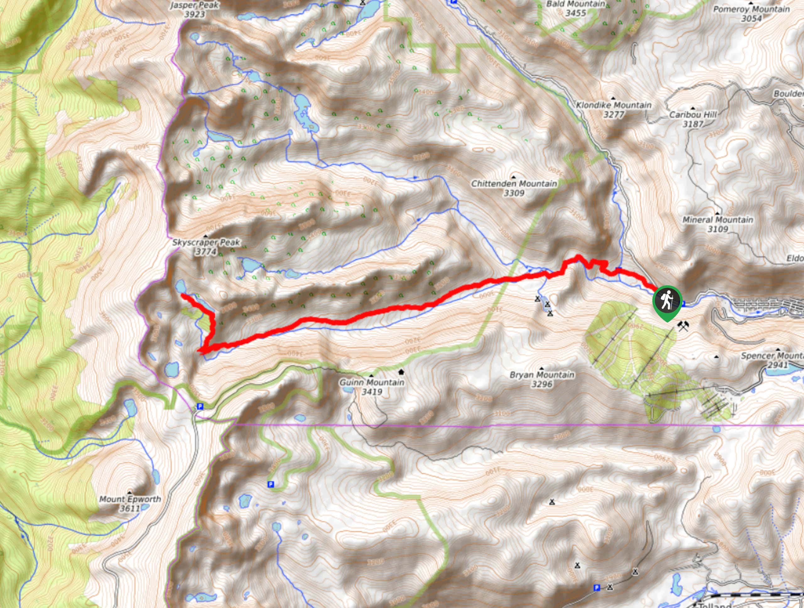
The Bob and Betty Lakes Trail begins at the Hessie Trailhead of the Fourth of July Road. Parking is limited so arrive early.

About
| Backcountry Campground | Yes, permits required. |
| When to do | June-November |
| Pets allowed | Yes - On Leash |
| Family friendly | Older Children only |
| Route Signage | Average |
| Crowd Levels | Moderate |
| Route Type | Out and back |
Betty and Bob Lakes Hike
Elevation Graph
Weather
Betty and Bob Lakes Hike Description
This trail is a crowd favorite. The Betty and Bob Lakes Hike is a great day hike up to the classic Colorado alpine lakes. As you traverse the trail through the aspen forests, hikers will be rewarded with sights of cascading waterfalls and expanse meadows littered with wildflowers in the summer months. The long and steady incline of the hike will tire your legs, but it is very manageable! This trail is a one stop shop for Indian Peaks hikes. Make sure to arrive early at the trailhead to secure a spot and beat the crowd.
Begin your adventure from the Hessie Trailhead. From the Hessie Road and Trailhead, hook onto the Devil’s Thumb Trail. Continue hiking the trail until you encounter a junction, veer left and head southwest on the Devil’s Thumb Bypass Trail. Stay on this trail until the next intersection. At this point hikers will bear left, merging onto the King Lake Trail. The King Lake Trail will continue west for quite a while as you hike through subalpine forests and gradually gain elevation. When you confront the next fork in the road, turn right. This path will divert you north onto the Bob and Betty Trail. Betty Lake will be the first lake along the path followed by Bob Lake shortly after. Situated on the border of the Continental Divide, these alpine lakes are picturesque against the craggy mountain backdrop.
Enjoy the vistas and do some fishing before retracing your steps down to the carpark.
Similar hikes to the Betty and Bob Lakes Hike hike

Caribou Pass Hike
The Caribou Pass Trail scales the west side of the Continental Divide. This short but steep hike will get your…

Buchanan Pass Loop
The Buchanan Pass Loop is an awesome adventure trail. Adults and kids alike will enjoy this wildflower-speckled trail as it…

Beaver Creek Trail
Beaver Creek Trail is a great wooded hike through the Colorado wilderness. With picturesque babbling brooks and past vast wildflower…
Comments