
Johns Lake Loop Trail
View Photos
Johns Lake Loop Trail
Difficulty Rating:
The hike through Johns Lake Loop Trail is a relaxing walk through nature and boasts views of the surrounding cool grey mountains, rushing waters in the nearby creeks and gorgeous views of Lake McDonald. Spend a few hours basking in the beauty of Johns Lake Loop Trail and see why it is a popular destination for hikers. This trail is horse-friendly, so you may be hiking alongside some furry companions.
Getting there
To get to Johns Lake Loop Trailhead from Mcdonald Lake Lodge, head South towards the Lake McDonald Lodge Loop. After 0.2mi, turn left onto Glacier Route 1 Road/Going-to-the-Sun Road and arrive at your destination after 1.3mi.

About
| When to do | April - October |
| Backcountry Campsites | No |
| Pets allowed | No pets, horses allowed |
| Family friendly | Yes |
| Route Signage | Average |
| Crowd Levels | Moderate |
| Route Type | Circuit |
Johns Lake Loop Trail
Elevation Graph
Weather
Johns Lake Loop Trail Description
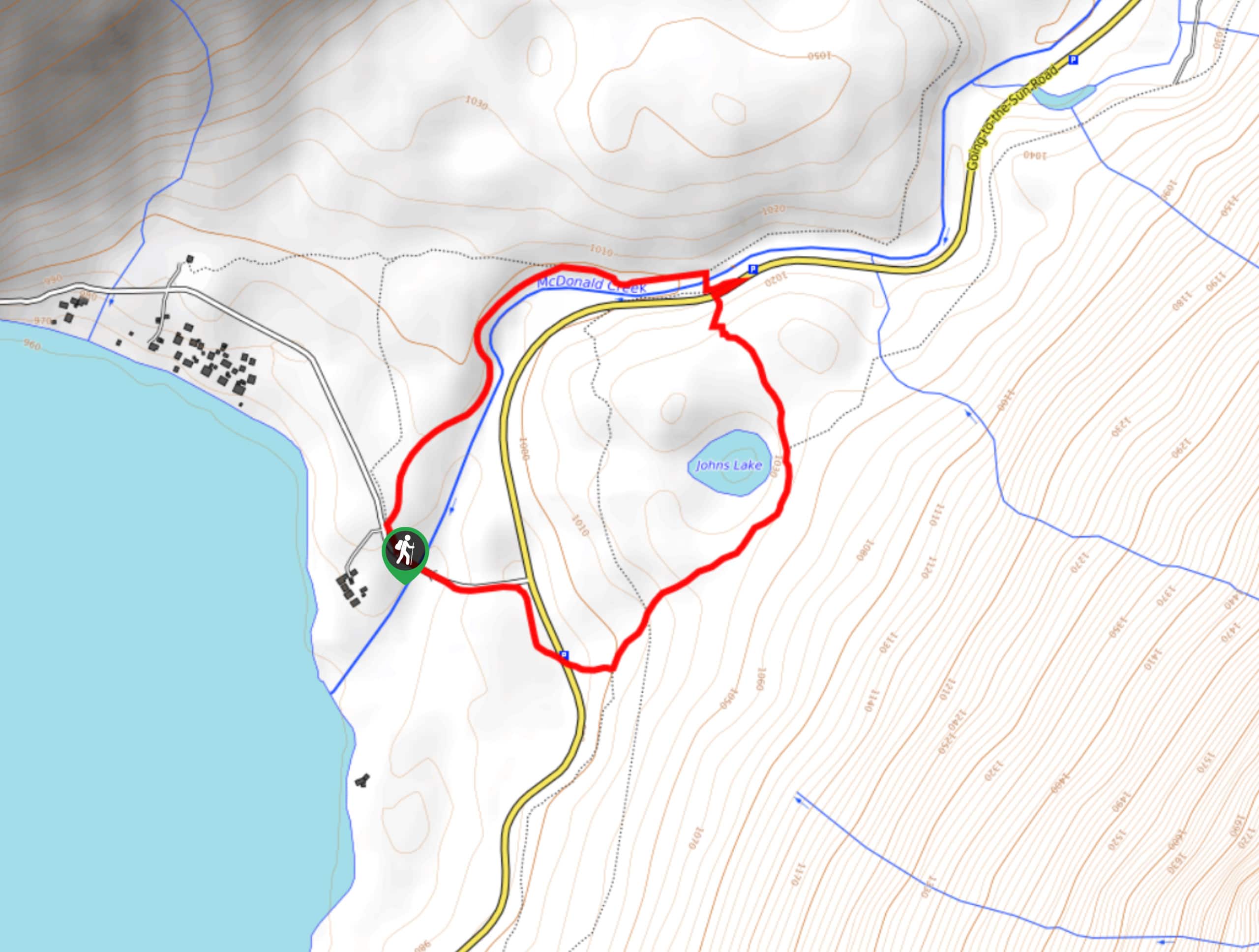
The hike through Johns Lake Loop Trail is filled with beautiful scenery and allows you to slow down and enjoy nature. The hike is a popular one, and the parking areas do not hold a lot of cars, so it is best to arrive in the early morning or late afternoon to secure a spot.
The trail begins at the Johns Lake Trailhead. However, you will see a sign for the Avalanche Trail junction; make sure to veer to the left here to stay on the trail as a left turn will take you down a horse path. After hiking through a dense forest of Red Cedars and Hemlock trees, at 0.3mi, you will see a view of the lake and a small trail to the side that will take you to the shore.
Continue on this path, and veer to the left at the Avalanche Trail junction and head towards Sacred Dancing Cascade. At 0.6mi, you will come out to Going to the Sun Road, cross this area when safe to do so and come across the cascade, of which the name derives from a Kootenai phrase that translates to “a good place to dance”. Follow the footbridge and head left to stay on track. At 1.1mi, you will see McDonald Falls, and at 0.3mi past, you will arrive at North Lake McDonald Road, where you turn left to avoid walking on the Going to the Sun Road’s shoulder.
You will then cross over McDonald Creek, where you will see Lake McDonald, Belton Hills and the Apgar mountains. Keep your eyes open for a small side trail 50ft from the bridge that will loop you back to the trailhead.
Find more epic hikes in Glacier National Park
Similar hikes to the Johns Lake Loop Trail hike

Fish Lake Trail
Fish Lake Trail is a mix between relaxing and heart pumping. The start of the trail takes you through a…

Quartz Creek Trail
Quartz Creek Trail is a relaxing hike on a remote trail in Glacier National Park. The hike takes you through…

Snyder Ridge Trail
Hiking through Snyder Ridge Trail takes you through a forest for most of the trail that follows the ridge along…
Comments