
Indian Heaven Trail #33
View Photos
Indian Heaven Trail #33
Difficulty Rating:
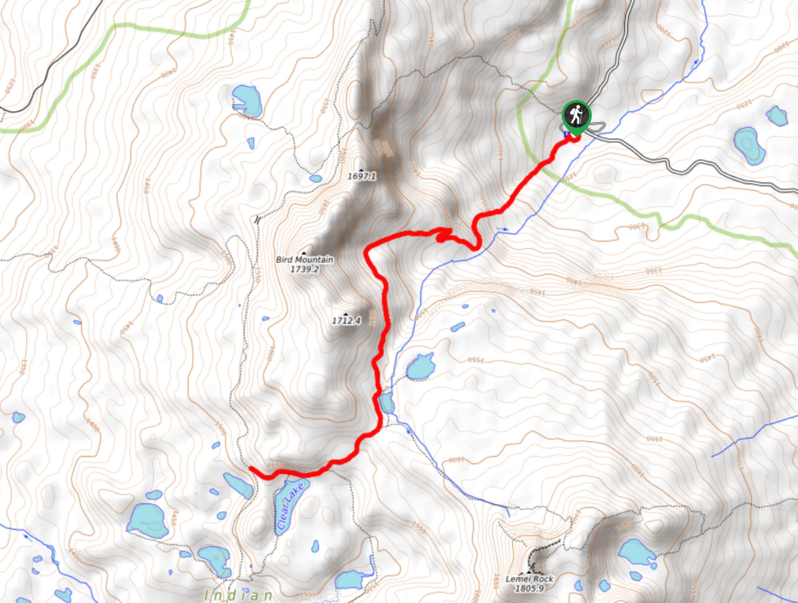
Indian Heaven is a gorgeous region for a hike, with carpets of wildflowers, plenty of lakes, and mountains. The Indian Heaven Trail #33 takes you from Cultus Creek Campground to four lakes near the base of Bird Mountain. It’s a nice hike if you’re staying at the campground, but we also recommend it for a day trip. There are lots of trails that can be used to extend your adventure if you want.
Getting there
The trailhead for the Indian Heaven Trail #33 is in Cultus Creek Campground.

About
| Backcountry Campground | Cultus Creek Campground |
| When to do | July-October |
| Pets allowed | Yes - On Leash |
| Family friendly | Older Children only |
| Route Signage | Average |
| Crowd Levels | High |
| Route Type | Out and back |
Indian Heaven Trail #33
Elevation Graph
Weather
Indian Heaven Trail #33 Description
Indian Heaven is an ideal place to spend a day hiking. With mountains, countless lakes, and more wildflowers than you could ever imagine, it offers lots to see. The Indian Heaven Trail #33 runs from Cultus Creek Campground past four lakes. You can extend this hike using the connecting trails if you’d like.
Beware, Indian Heaven is full of bugs in the summertime. You’ll need every protection you can get against the mosquitoes and horseflies. We recommend a hike in later summer to avoid the bugs.
Beginning from the campground, begin hiking up the basin wall, taking a few switchbacks to skirt underneath Bird Mountain. You’ll pass Cultus Lake and Deep Lake. Stay right after Cultus to Pass Clear Lake and Deer Lake. The hike ends next to Deer Lake, so turn around and retrace your steps.
Similar hikes to the Indian Heaven Trail #33 hike

Ptarmigan Trail
Ptarmigan Trail is a 4.2mi moderate trail near the base of Mount Saint Helens. This trail is suitable…

Lakes Trail #211 Loop
The Lakes Trail #211 Loop is used as both a full-day hike and for backpacking trips. This trail isn’t for…

Boundary West Trail
Boundary West Trail is a hike near Mount Saint Helens that doesn’t see much traffic, making it a nice pick…
Comments