
Three Mile Creek Trail
View Photos
Three Mile Creek Trail
Difficulty Rating:
Featuring numerous stream crossings and diverse scenery, the Three Mile Creek Trail is one of our favorite adventures in the Pike National Forest. Shared with horse riders, the terrain is easy to navigate, and the path is explicit. If you are seeking a wonderfully scenic day-hike through Colorado’s various landscapes, then the Three Mile Creek Trail is your ideal destination.
Getting there
Find the Three Mile Creek Trailhead off Geneva Road at the Whiteside Campground.

About
| Backcountry Campground | Dispersed backcountry camping, restrictions apply. |
| When to do | May-October |
| Pets allowed | Yes - On Leash |
| Family friendly | Older Children only |
| Route Signage | Average |
| Crowd Levels | High |
| Route Type | Out and back |
Three Mile Creek Trail
Elevation Graph
Weather
Three Mile Creek Hike Description
Hike through lush aspen forests, beside towering granite cliffs and past grazing wildlife on the Three Mile Creek Trail. This hike is top-notch. Travel through several types of terrain that will expose you to views of the surrounding wilderness. Get your blood pumping and legs moving as you ascend the trail through mountain valleys. This excursion is lengthy, but there are several stream crossings for you and your pup to rehydrate, just make sure you filter the water first. Ensure to wear appropriate footwear and note that some log bridges are washed out, so you will have to wade across the creek’s shallow waters. This popular trail is especially busy in the fall when the aspens are at their peak vibrance, we suggest arriving early to secure a parking spot in the very small car park.
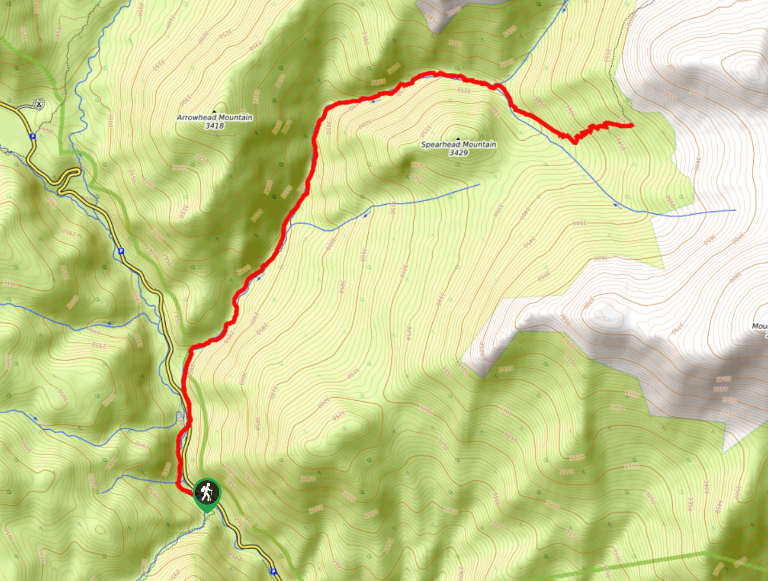
The Three Mile Creek Trail will guide you along the Geneva Road for a few clicks from the trailhead before guiding you to the other side of the road and under tree coverage. Follow the route as it curves you with the bends of the Three Mile Creek. Hike along the creek’s edge, intersecting with it on numerous occasions. Bask in the beauty of the surrounding forests as you gradually climb northwest. Continue hiking, and you will eventually find yourself in the rocky valley between Arrowhead Mountain and Spearhead Mountain. Enjoy the granite ridges that line the path, and the trail will begin to curve east around the base of Spearhead Mountain. Trek along the creek’s edge, and the route will eventually deliver you to a meadowland before hiking up a steep ridge. Navigate a few switchbacks and enjoy the view from the exposed hillside.
This is your turnaround point. If you still have an itch to adventure further, follow the more primitive section of the trail southeast up to the summit of Mount Logan. If you tuckered out and are ready to return, simply backtrack along the path back to the parking lot.
Similar hikes to the Three Mile Creek Trail hike

Hankins Pass Hike
The Hankins Pass Hike is a quintessential adventure across the Lost Creek Wilderness. The hike demonstrates the diversity of the…

Miller Gulch Loop Trail
The Miller Gulch Loop Trail is a scenic meadowland adventure in the Pike National Forest. Hike through grassy meadows laden…

The Castle Hike
The Castle Hike is an exciting adventure up the steep, forested terrain to The Castle Rock. From atop the summit,…
Comments