
Tanglewood Trail
View Photos
Tanglewood Trail
Difficulty Rating:
The Tanglewood Trail is a demanding hike up a woodland gulch to scenic alpine lakes. Who doesn’t love a good forest hike, right? Well, this one will guide you over Deer Creek, through lush aspens and pines, above the timberline, and up to an overlook of crystalline alpine lakes. It really can't be beat. On your next adventure to the Mount Evans Wilderness, add the Tanglewood Trail to your itinerary.
Getting there
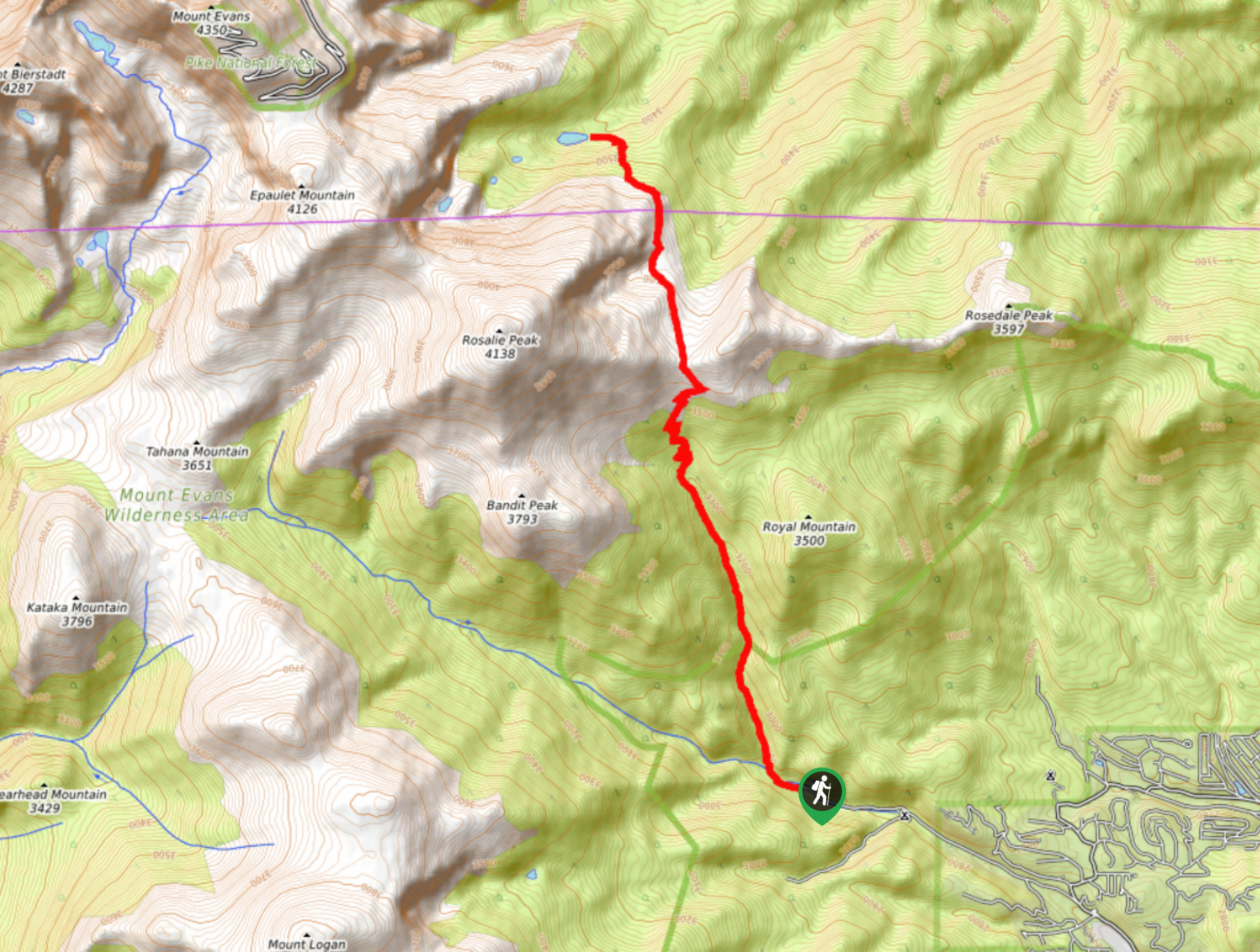
The Tanglewood Trail departs from the Deer Creek Trailhead at the end of Deer Creek Road.

About
| Backcountry Campground | Dispersed Backcountry Camping, see rules and regulations. |
| When to do | May-October |
| Pets allowed | Yes - On Leash |
| Family friendly | No |
| Route Signage | Average |
| Crowd Levels | High |
| Route Type | Out and back |
Tanglewood Trail
Elevation Graph
Weather
Tanglewood Hike Description
The Tanglewood Hike is a diverse adventure through the Mount Evans Wilderness. This technical and lengthy trail is not for the faint of heart! Instead, this excursion is reserved for hikers who are comfortable scrambling steep terrain, crossing streams and navigating primitive trails. Though this path is popular, there are sections of the route that are hard to follow. We recommend following the Trail GPS to avoid getting turned around. Additionally, make sure you pack plenty of water and know your limits when it comes to elevation gain. Turn around if you begin to feel ill.
Embark on your journey along the Tanglewood Hike from the Deer Creek Trailhead. From the trailhead, track northwest on the Tanglewood Trail. Cross the small log bridge over Deer Creek and begin hiking through the forested gulch. Gradually climbing through the lush aspen trail, the trail will begin to ascend the timberline. Atop the tree shade, you will be exposed to awe-inspiring vistas of the encompassing snow-dusted peaks. Continue climbing up the increasingly rocky path along the exposed ridge. Soon the trail will guide you back below the treeline and down to the Beartrack lakes.
Explore the shores of the small alpine lakes, and if you are feeling adventurous, hike up past all three lakes to the smallest lake situated on a towering cliff above. Enjoy the shimmering lakes and the sights of the surrounding peaks before heading back. When you are ready to leave, retrace your steps all the way back to the parking lot.
Similar hikes to the Tanglewood Trail hike

Hankins Pass Hike
The Hankins Pass Hike is a quintessential adventure across the Lost Creek Wilderness. The hike demonstrates the diversity of the…

Miller Gulch Loop Trail
The Miller Gulch Loop Trail is a scenic meadowland adventure in the Pike National Forest. Hike through grassy meadows laden…

The Castle Hike
The Castle Hike is an exciting adventure up the steep, forested terrain to The Castle Rock. From atop the summit,…
Comments