
Stout Trail via Horsetooth Falls
View Photos
Stout Trail via Horsetooth Falls
Difficulty Rating:
Travel through all the best scenery that the Horsetooth Mountain Open Space has to offer. The Stout Trail via Horsetooth Falls is a scenic adventure the whole family will enjoy. Explore the cascading waterfalls before trekking through the grassy meadows, abundant with vibrant wildflowers and set against the mountainous Colorado backdrop. Lace up your shoes! What are you waiting for?
Getting there
The Stout Trail via Horsetooth Falls is located within the Horsetooth Mountain Open Space off W County Road Road 38E.

About
| Backcountry Campground | Yes, only at designated backcountry campsites. See rules and regulations. |
| When to do | March-October |
| Pets allowed | Yes - On Leash |
| Family friendly | Yes |
| Route Signage | Average |
| Crowd Levels | High |
| Route Type | Lollipop |
Stout Trail via Horsetooth Falls
Elevation Graph
Weather
Stout Trail via Horsetooth Falls Hike Description
We don’t know about you, but there is just something about waterfall hikes that are so appealing. Perhaps it’s the meditative sounds or the mesmerizing cascading waters over the falls. Nevertheless, we love a good waterfall hike, and you will pass the falls not once but twice on the Stout Trail via Horsetooth Falls Hike. Trek past the charming waterfall before looping around the grassy meadows overlooking the Horsetooth Reservoir and Fort Collins. Make sure to pack a sunhat and sunscreen on sunny days because the path is almost entirely unshaded. Because this trail is located inside the Horsetooth Mountain Open Space, visitors are subject to paying a $9USD pass at the gateway’s kiosk.
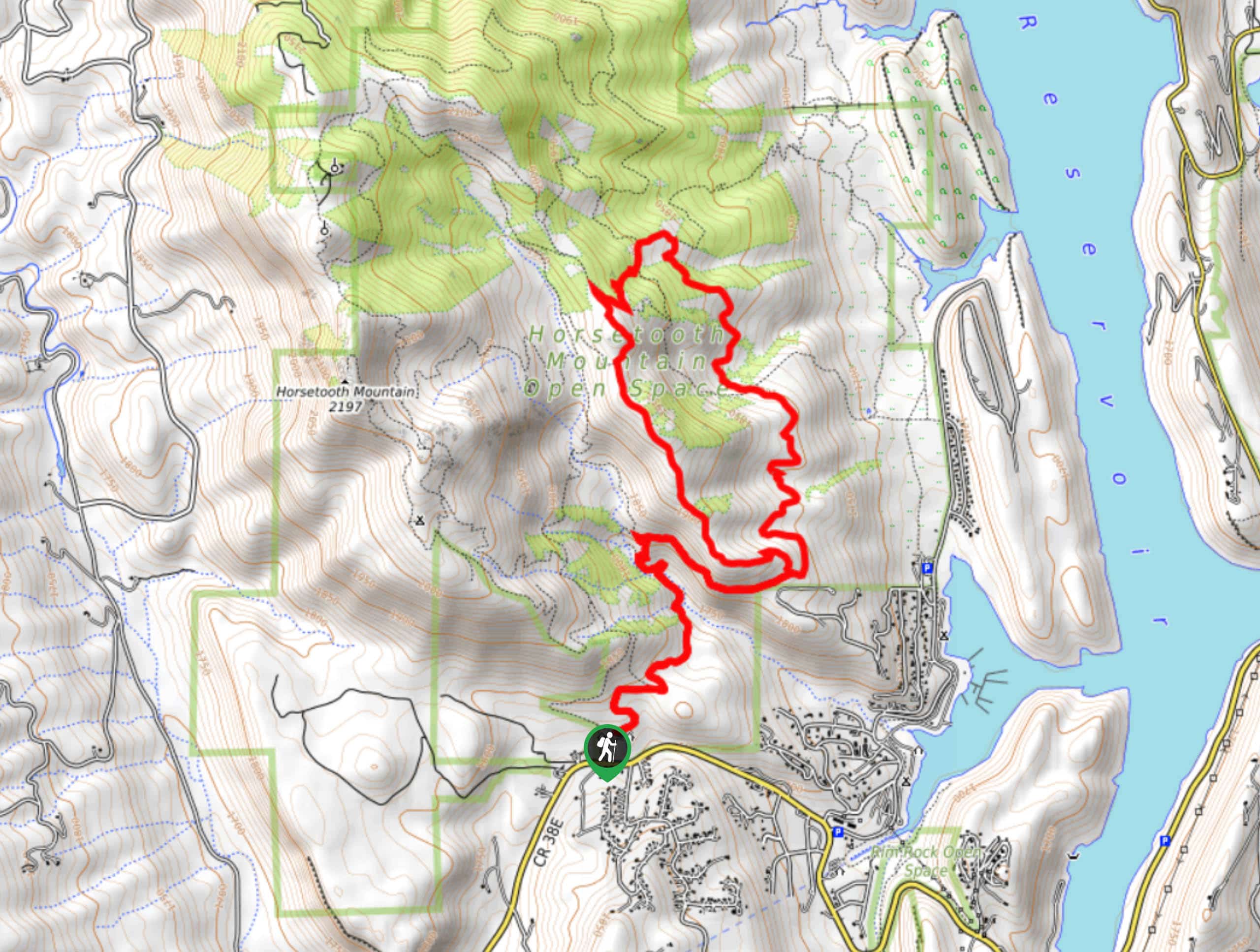
Embark on your adventure around the Stout Trail via Horsetooth Falls from the Horsetooth Mountain Trailhead. From the trailhead, take the Horsetooth Rock Trail before quickly merging onto the Horsetooth Falls Trail. Hike over Spring Creek to the Falls. Explore the falls before turning right onto the Spring Creek Trail. This route will guide you down to the Stout Trail. You can trek this loop in either direction, but we went counterclockwise this time. Veer right on the Stout Trail. Hike along the path through the meadowlands. Enjoy the sights of wildflowers and the mountainous landscape in the distance. Ignore the intersecting Towers Trail and hike until you meet a junction.
Take a left onto the Sawmill Trail, followed by another quick left on the Loggers Trail, then a right onto the Herrington Trail. Hike the Herrington Trail, then take a right onto the Towers Trail, and then a left onto the Herrington Trail again. Soon you will meet another junction, veer left, reconnecting with the Stout Trail. Thankfully you won’t have another intersection for a while. Hike this path until you eventually meet back up with the Spring Creek Trail. Retrace your steps along the path and back to the falls. Dip your tired feet in the waters before backtracking along the Horsetooth Falls Trail to the car park and trailhead.
Similar hikes to the Stout Trail via Horsetooth Falls hike

Miller Gulch Loop Trail
The Miller Gulch Loop Trail is a scenic meadowland adventure in the Pike National Forest. Hike through grassy meadows laden…

The Castle Hike
The Castle Hike is an exciting adventure up the steep, forested terrain to The Castle Rock. From atop the summit,…

Rutherford Trail
The Rutherford Hike is a charming nature walk in Georgetown Colorado. This secluded trail is a wonderful adventure the whole…
Comments