
Staunton Ranch to Mason Creek Hike
View Photos
Staunton Ranch to Mason Creek Hike
Difficulty Rating:
The Staunton Ranch to Mason Creek Hike is another stunning network of trails in the Staunton State Park. The Staunton Ranch to Mason Creek Trail exhibits all the best characteristics of quintessential Colorado typographies: lush meadows, craggy cliffs, mixed aspen and pine grove, and mountain streams. Of course, there are also unforgettable mountain views!
Getting there
The Staunton Ranch to Mason Creek Hike is in the Staunton State Park off S Elk Creek Road.

About
| Backcountry Campground | No |
| When to do | March-October |
| Pets allowed | Yes - On Leash |
| Family friendly | Older Children only |
| Route Signage | Good |
| Crowd Levels | High |
| Route Type | Circuit |
Staunton Ranch to Mason Creek Hike
Elevation Graph
Weather
Staunton Ranch to Mason Creek Hike Description
Hike, bike or horse ride, the Staunton Ranch to Mason Creek Trail is an outdoor enthusiast’s dream. Located within the Staunton State Park outside of Denver, this excursion is heavily trafficked, especially on weekends. If you wish to avoid the crowds, consider a weekday adventure to the State Park. This trail is well managed and easy to navigate, but it may be a bit long for kids—older children with hiking experience should have no issues! Ensure to pack plenty of water to stay hydrated along this excursion. It is also worth noting the route traverses exposed areas, so lather on the sunscreen on sunny summer days. Additionally, visitors are required to purchase a $10USD day pass.
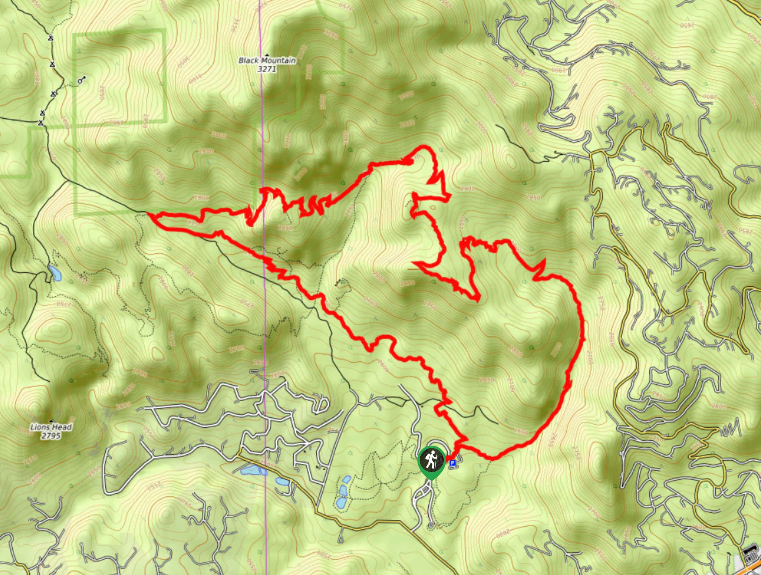
Commence your journey around the Staunton Ranch to Mason Creek Hike from the Staunton Ranch Trailhead. This circuit hike can be completed from either direction, but we prefer tracking clockwise on this one. From the trailhead, track northwest along the Staunton Ranch Trail. Hike along the meadowed path along the base of the striking cliffs. Notice climbers ascending the ridges and continue along the path. Ignore intersecting routes and follow the Staunton Ranch Trail until it’s end. At the path’s end, it will merge onto a service road. Hike along the service road until you meet a junction. Here, veer right and you will be diverted up the Border Line Trail.
Navigate switchbacks and continue climbing until you reach an overlook. Enjoy the expansive Front Range views from the overlook and continue along the route. Pass Old Mill and take the Bear Paw Trail. This path will guide you down to two more scenic overlooks before merging into the Mason Creek Trail. Track the Mason Creek Trail down the forested gulch and alongside the Mason Creek. Hike this route until it delivers you back to the trailhead.
Similar hikes to the Staunton Ranch to Mason Creek Hike hike

Hankins Pass Hike
The Hankins Pass Hike is a quintessential adventure across the Lost Creek Wilderness. The hike demonstrates the diversity of the…

Miller Gulch Loop Trail
The Miller Gulch Loop Trail is a scenic meadowland adventure in the Pike National Forest. Hike through grassy meadows laden…

The Castle Hike
The Castle Hike is an exciting adventure up the steep, forested terrain to The Castle Rock. From atop the summit,…
Comments