
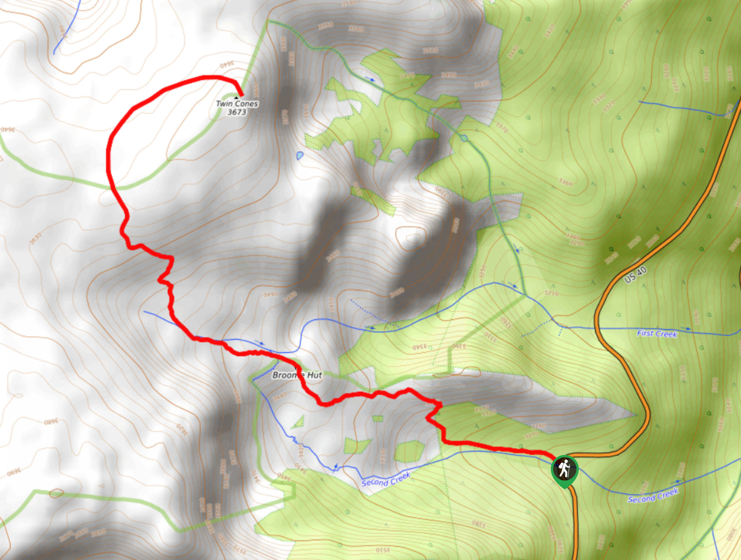
Second Creek Trail
View Photos
Second Creek Trail
Difficulty Rating:
The Second Creek Trail is an epic adventure for the whole family. Travel up the woodland path, past aspen groves, through meadows and up to a scenic overlook at the Broome Hut, all before ascending the summit. Get in your daily movement and blow off some steam as you ascend the gradual grade to the peaks.
Getting there
The Second Creek Trail is off Highway 40.

About
| Backcountry Campground | Dispersed Backcountry Camping, restrictions apply. |
| When to do | April-November |
| Pets allowed | Yes - On Leash |
| Family friendly | Older Children only |
| Route Signage | Average |
| Crowd Levels | High |
| Route Type | Out and back |
Second Creek Trail
Elevation Graph
Weather
Second Creek Hike Description
Immerse yourself in wilderness and enjoy the panoramic vistas that line the path the entirety of the way. The Second Creek Trail is an awesome adventure into the Colorado wilderness. Hike along Second Creek and up to the popular Broome Hut and overlook. This summit hike is short, but the trail will climb steep terrain to the peak. Though it is labeled as family-friendly, we consider only the trek up to the Broome Hut manageable for young children. The ascent up to the summit from the hut is rocky and exposed, but older children and novice hikers should be ok. Make sure to wear layers as the exposed sections of the route will be windy and cold.
Begin your adventure up the Second Creek Trail from the parking lot. Track the Second Creek Trail northwest along the babbling brook. Hike through the woodlands to the Broome Hut. At the hut, the terrain will be meadowed and exposed. Enjoy the panoramic views of the Front Range wilderness before continuing up the path. Travel up the creek and to the steep, rocky terrain. Navigate the switchbacks up the rocky ridge. The trail will then begin to curve northeast up to Twin Cones summit.
Revel in the 360-degree views of the Front Range and the subalpine woodlands below. Explore the summit and refuel prior to commencing your descent. When you are ready to return, retrace your steps back along the route to the carpark.
Similar hikes to the Second Creek Trail hike

Hankins Pass Hike
The Hankins Pass Hike is a quintessential adventure across the Lost Creek Wilderness. The hike demonstrates the diversity of the…

Miller Gulch Loop Trail
The Miller Gulch Loop Trail is a scenic meadowland adventure in the Pike National Forest. Hike through grassy meadows laden…

The Castle Hike
The Castle Hike is an exciting adventure up the steep, forested terrain to The Castle Rock. From atop the summit,…
Comments