
Mount Nystrom Trail
View Photos
Mount Nystrom Trail
Difficulty Rating:
The Mount Nystrom Trail is an exciting adventure above the clouds. Hike the exposed path to the summit and enjoy panoramic views the entirety of the way. You will be granted incredible views of the Continental Divide and surrounding snow-dusted peaks.
Getting there
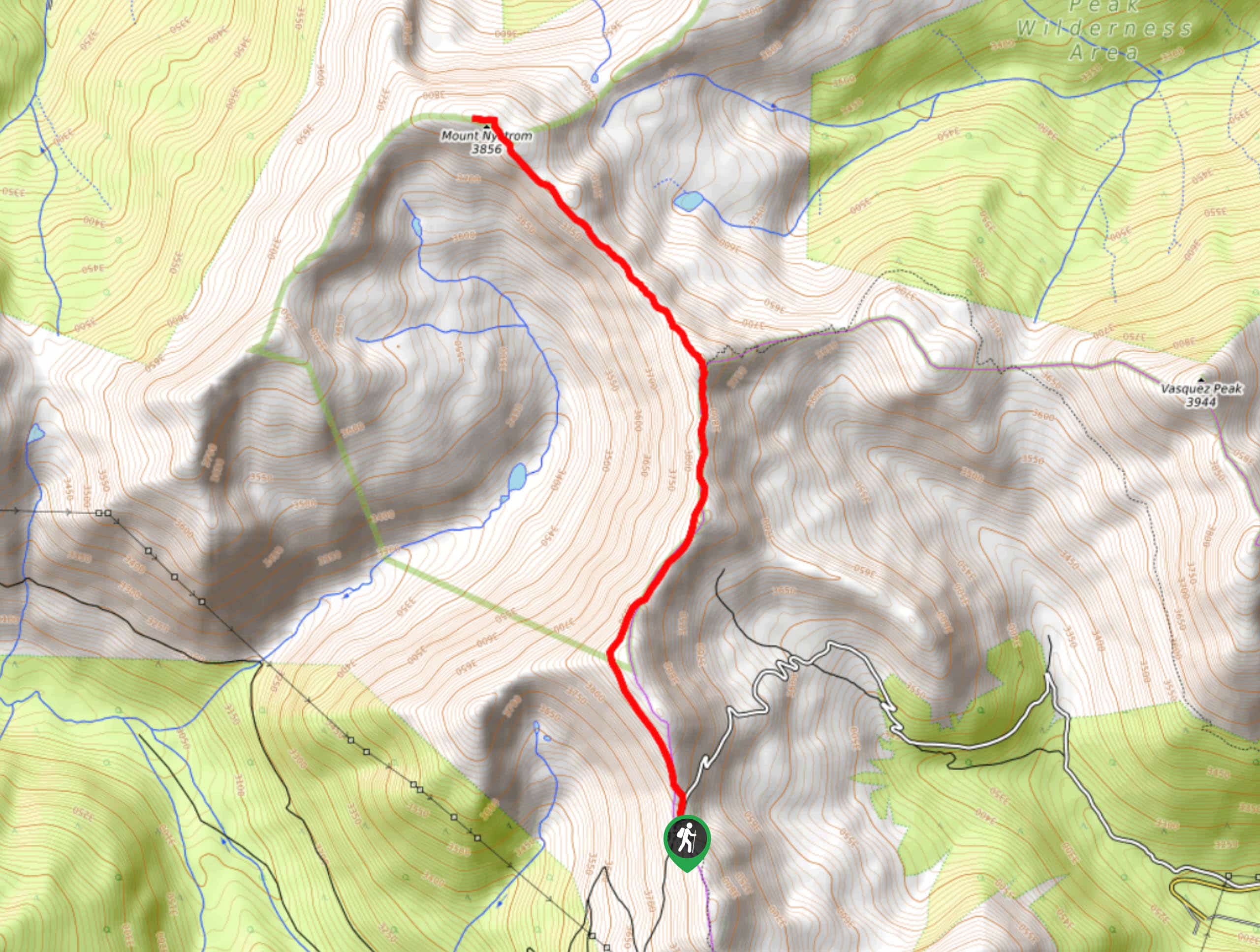
The Mount Nystrom Hike is located off Jones Pass Road.

About
| Backcountry Campground | Dispersed Backcountry Camping, restrictions apply. |
| When to do | May-November |
| Pets allowed | Yes - On Leash |
| Family friendly | Yes |
| Route Signage | Average |
| Crowd Levels | Low |
| Route Type | Out and back |
Mount Nystrom Trail
Elevation Graph
Weather
Mount Nystrom Hike Description
The Mount Nystrom Hike is an ideal summit adventure for novice hikers and families alike. Trek the undulating path through the clouds and ascend Mount Nystrom. Note this trail is entirely exposed, meaning you will be granted awe-inspiring views the entirety of your adventure, but you will also gamble with inclement weather. At such a high altitude you can expect afternoon storms, these usually come on quite suddenly so keep an eye on the surrounding clouds and check the weather prior to your hike.
Begin your Mount Nystrom Hike from the Berthoud Pass West Trailhead. From here, track the Berthoud Pass Trail north. The path will undulate all the way to the summit—mind your footing on loose rocks and take breaks as necessary. Hike among the clouds and revel in the expansive views as you trek along the path. Eventually, the Berthoud Pass West Trail will begin to descend east. Here, stay left and hike along the worn Mount Nystrom Trail. Hike across the ridge and ascend the peak.
From atop the peak notice Vasquez Lake below and Vasquez Peak in the southeast. Revel in the impressive views of the Continental Divide and Front Range scenery. When you are ready, retrace your steps along the path back to the trailhead.
Similar hikes to the Mount Nystrom Trail hike

Miller Gulch Loop Trail
The Miller Gulch Loop Trail is a scenic meadowland adventure in the Pike National Forest. Hike through grassy meadows laden…

The Castle Hike
The Castle Hike is an exciting adventure up the steep, forested terrain to The Castle Rock. From atop the summit,…

Rutherford Trail
The Rutherford Hike is a charming nature walk in Georgetown Colorado. This secluded trail is a wonderful adventure the whole…
Comments