Mount Evans via Chicago Creek Hike
View Photos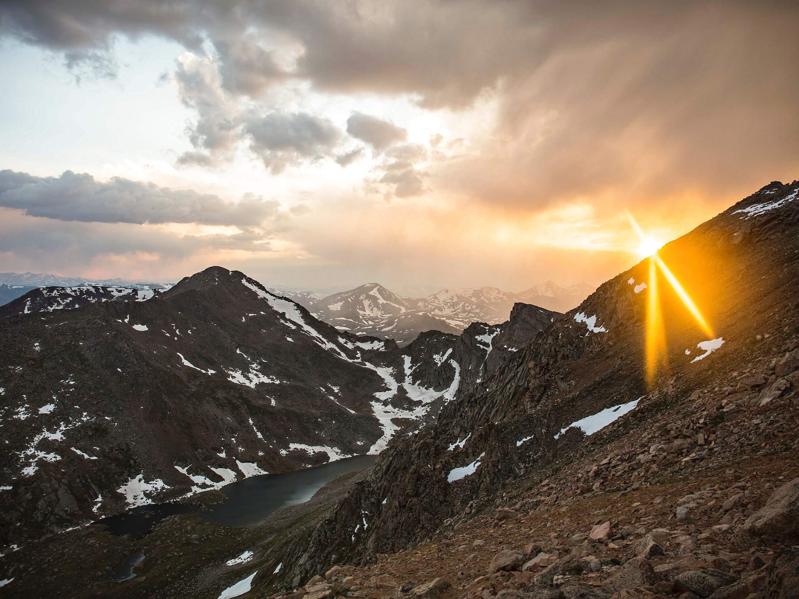
Mount Evans via Chicago Creek Hike
Difficulty Rating:
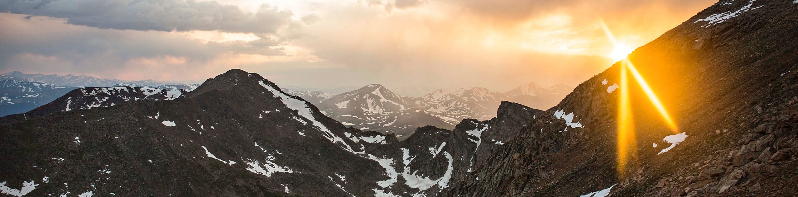
The Mount Evans via Chicago Creek Hike is a beautiful, but demanding hike through Colorado’s wilderness. Perhaps one of the most picturesque hikes in the Front Range, this trail will guide you past several crystalline alpine lakes before delivering you to the base of the postcard worthy Mount Evans. This hike may be challenging, but the scenery supersedes the effort.
Getting there
Your adventure up Mount Evans via Chicago Creek Hike begins at the Echo Lake Parking Lot. Find the Echo Lake Carpark off of highway CO-103.

About
| Backcountry Campground | Dispersed Backcountry Camping, see rules and regulations. |
| When to do | April-October |
| Pets allowed | Yes - On Leash |
| Family friendly | No |
| Route Signage | Average |
| Crowd Levels | Moderate |
| Route Type | Out and back |
Mount Evans via Chicago Creek Hike
Elevation Graph
Weather
Mount Evans via Chicago Creek Hike Description
Hike the Mount Evans via Chicago Creek Trail and you will be in awe with every step of the way. This extremely scenic adventure might just be one of our favorite hikes in the Front Range. Traverse the path past several alpine lakes and through lush meadows and summit Mount Evans. Challenging, but undoubtedly rewarding, hikers need to prepare for this excursion.
Wear proper hiking boots and consider bringing hiking poles and microspikes for the steep ascent to the summit. High-elevation ascents to the peak may prove challenging if you are not acclimated to the extreme elevation, take it slow, bring plenty of water, and know your boundaries. Also, layers are also a must! Be prepared for a cooler, windier climate at the peak’s summit.
The mountain Evans vis Chicago Creek Hike is a lengthy adventure through the wilderness, pack plenty of snacks and water. Additionally, this trek weaves between well-maintained park paths and primitive mountain trails. We suggest checking the trail GPS as you progress along to ensure you are on the right path. Along with proper gear and hydration, ensure you bring a camera, because around every turn there is an amazing vista.
If we haven’t made it evident already, we really like this hike, and we know you will too. The Mount Evans via Chicago Creek Trail is an incredible trek through various Colorado landscapes and the terrain is just challenging enough. Pass not one, but five shimmering alpine lakes as you ascend the trail to the Mount Evans Summit. Though you can drive up the peak, a hike through the Mount Wilderness is infinitely more rewarding. If you’re tired by the time you reach the summit, you could always try to bum a ride back down to the trailhead.
Begin this exciting Front Range adventure from the Echo Lake Parking Lot. Note that there are facilities at this trailhead. Begin by heading south on the Chicago Lakes Trail. Follow this forested path past Echo Lake and continue along the trail. You will gradually be gaining elevation until you encounter switchbacks up to the Idaho Springs Reservoir. Navigate the rocky switchbacks over the ridge. At this point you will meet a junction, veer left and progress along the old service road to the reservoir. At this point the trail will become increasingly meadowed as you gain elevation.
Enjoy the sights of the Idaho Springs Reservoir and continue south up the trail. Keep an eye out for moose, bears and marmots along this path! Steadily gaining elevation hike through the meadows and aspens until you reach Lower Chicago Lake. As you pass the lower lake and climb the route, the Upper Chicago Lake will come into view. From these lakes you will be bestowed with panoramic vistas of Mount Evans, Mount Warren and Mount Spalding.
Enjoy the views of the flanking snow dusted mountains as you continue the ascend up the rocky crest. Maneuver the steep rocky scree up to Summit Lake. From here, enjoy an overlook of the Chicago Lakes in the north and Mount Evan in the south. At this point the terrain becomes extremely technical, and snowy as you scramble up the rock talus up Mount Spalding. Carefully navigate the ridge and summit the first peak.
From Mount Spalding, head south over the pass and hike among mountain goats. Track along the rocky ridge up Mount Evans. Mind your footing as the snowy vale may be slippery. Micospikes would likely come in handy. Navigate the steep path to the peak. When you summit Mount Evans enjoy stunning 360-degree views of the surrounding craggy peaks and ranges.
Revel in the breathtaking Colorado scenery and relax before commencing your descent. Retrace your steps all the way back to the trailhead or get someone to pick you up at the summit.
Trail Highlights
Mount Evans
Mount Evans is the highest peak in the Mount Evans Wilderness and Colorado Front Range. With an elevation of 14265ft, Mount Evans is ranked 14th among Colorado’s 14ers. This behemoth of a Mountain dominates the skyline and can be seen from miles away. A vehicle compatible road winds up the southeastern side of the mountain, making it one of the most popular scenic lookouts in the Front Range, and the highest vehicle accessible overlook in North America! This impressive mountain also houses many forms of wildlife. Mountain goats are abundant along the mountain’s ridges, but mountain lions, black bears and pikas are often sighted in the area.
Insider Hints
Wear a bear bell to help prevent any unwelcome run-ins with wildlife along the trail.
Wear plenty of layers as the summit will be windy and cold.
If you are feeling adventurous and have the proper gear, ski down Mount Evans!
Be sure to pack plenty of water as there are limited water sources as you begin to ascend the mountains.
Similar hikes to the Mount Evans via Chicago Creek Hike hike

Hankins Pass Hike
The Hankins Pass Hike is a quintessential adventure across the Lost Creek Wilderness. The hike demonstrates the diversity of the…

Miller Gulch Loop Trail
The Miller Gulch Loop Trail is a scenic meadowland adventure in the Pike National Forest. Hike through grassy meadows laden…

The Castle Hike
The Castle Hike is an exciting adventure up the steep, forested terrain to The Castle Rock. From atop the summit,…
Comments