
Maryland Mountain Hike
View Photos
Maryland Mountain Hike
Difficulty Rating:
The Maryland Mountain Hike is a scenic adventure up to the summit of Maryland Mountain. This stimulating trail will guide you past the historic Gilpin Tramway, past granite outcroppings and up to the pine dotted summit. Hikers, bikers, and history buffs alike will surely be impressed by this scenic trail
Getting there
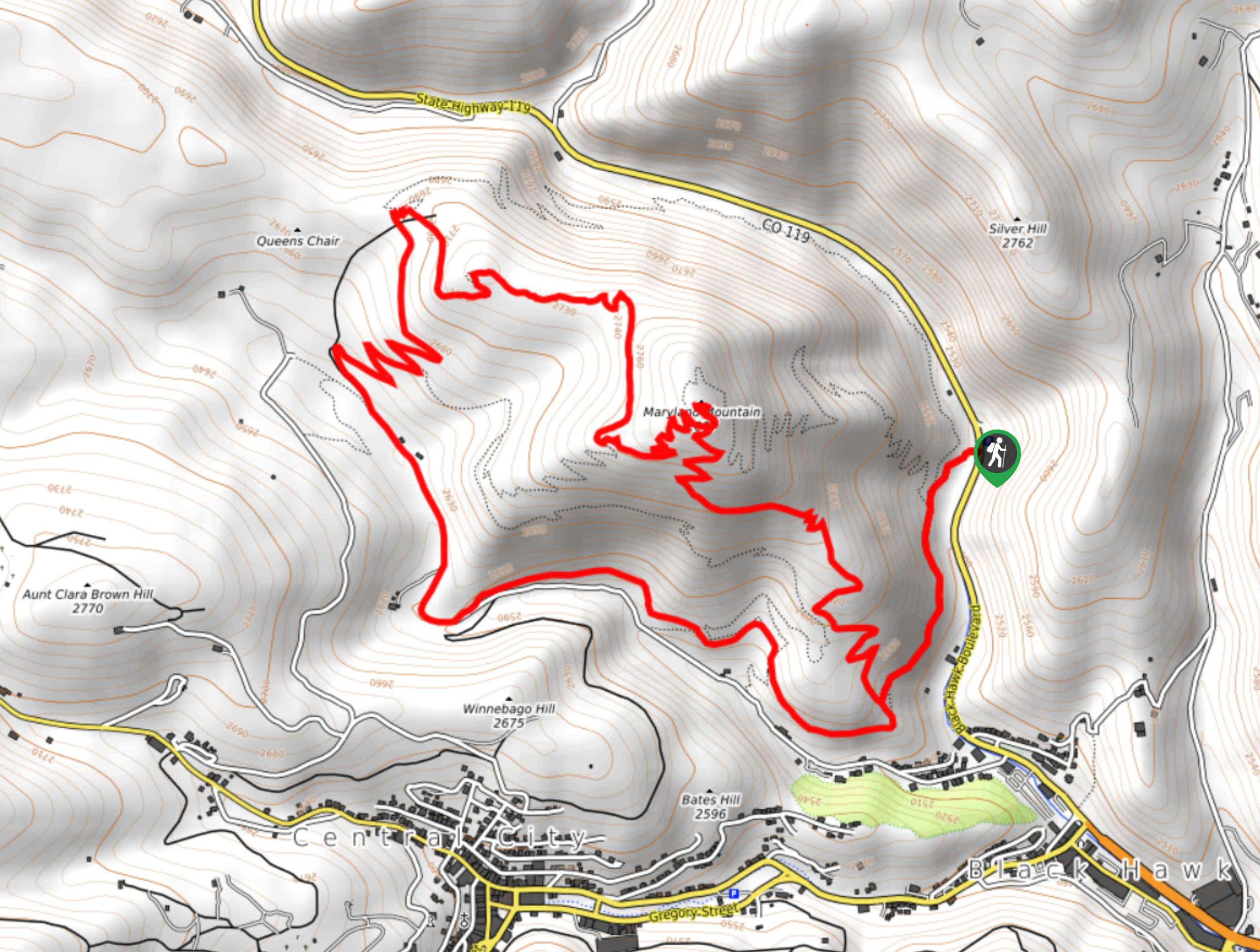
Find the Maryland Mountain Trailhead off Black Hawk Boulevard.

About
| Backcountry Campground | No |
| When to do | April-October |
| Pets allowed | Yes - On Leash |
| Family friendly | Older Children only |
| Route Signage | Average |
| Crowd Levels | Moderate |
| Route Type | Lollipop |
Maryland Mountain Hike
Elevation Graph
Weather
Maryland Mountain Hike Description
Travel back in time as you hike along the historic Gilpin Tramway Trail. The Maryland Mountain Hike will lead you along the historic tramway that operated from 1887 to 1917 to transport gold to and from remote regions. This scenic adventure will also reward you with stunning nature sights. Hike past Clear Creek, through ponderosa pines, and past granite outcroppings to the panoramic overlook at the summit. This trail is a crowd favorite, and we understand why. If you are hoping to avoid sharing the path with fellow adventurers, consider a weekday hike.
Begin your Maryland Mountain Hike from the Historic Gilpin Tramway Trailhead. Hike across Black Hawk Boulevard and walk along the Historic Gilpin Tramway Trail. Trek along the historic path and notice Black Hawk Mill. Continue hiking the Historic Gilpin Tramway Trail through the forested gulch until you meet the Quartz Valley Trail. Veer right and ascend the path. At the intersection, turn right onto the Easy Money Trail and navigate the switchbacks. Hike the Easy Money Trail all the way to the summit of Maryland Mountain.
Revel in the expansive views of the mountainous landscape from atop the peak. Take a break and enjoy the scenery before beginning your descent. When you are ready, descend the Summit Trail. Mind your footing as you hike down the steep terrain. Travel along the Summit Trail until you meet back up with the Historic Gilpin Tramway Trail. Veer left, and retrace your steps all the way back to the trailhead.
Similar hikes to the Maryland Mountain Hike hike

Hankins Pass Hike
The Hankins Pass Hike is a quintessential adventure across the Lost Creek Wilderness. The hike demonstrates the diversity of the…

Miller Gulch Loop Trail
The Miller Gulch Loop Trail is a scenic meadowland adventure in the Pike National Forest. Hike through grassy meadows laden…

The Castle Hike
The Castle Hike is an exciting adventure up the steep, forested terrain to The Castle Rock. From atop the summit,…
Comments