Herman Gulch Trail
View Photos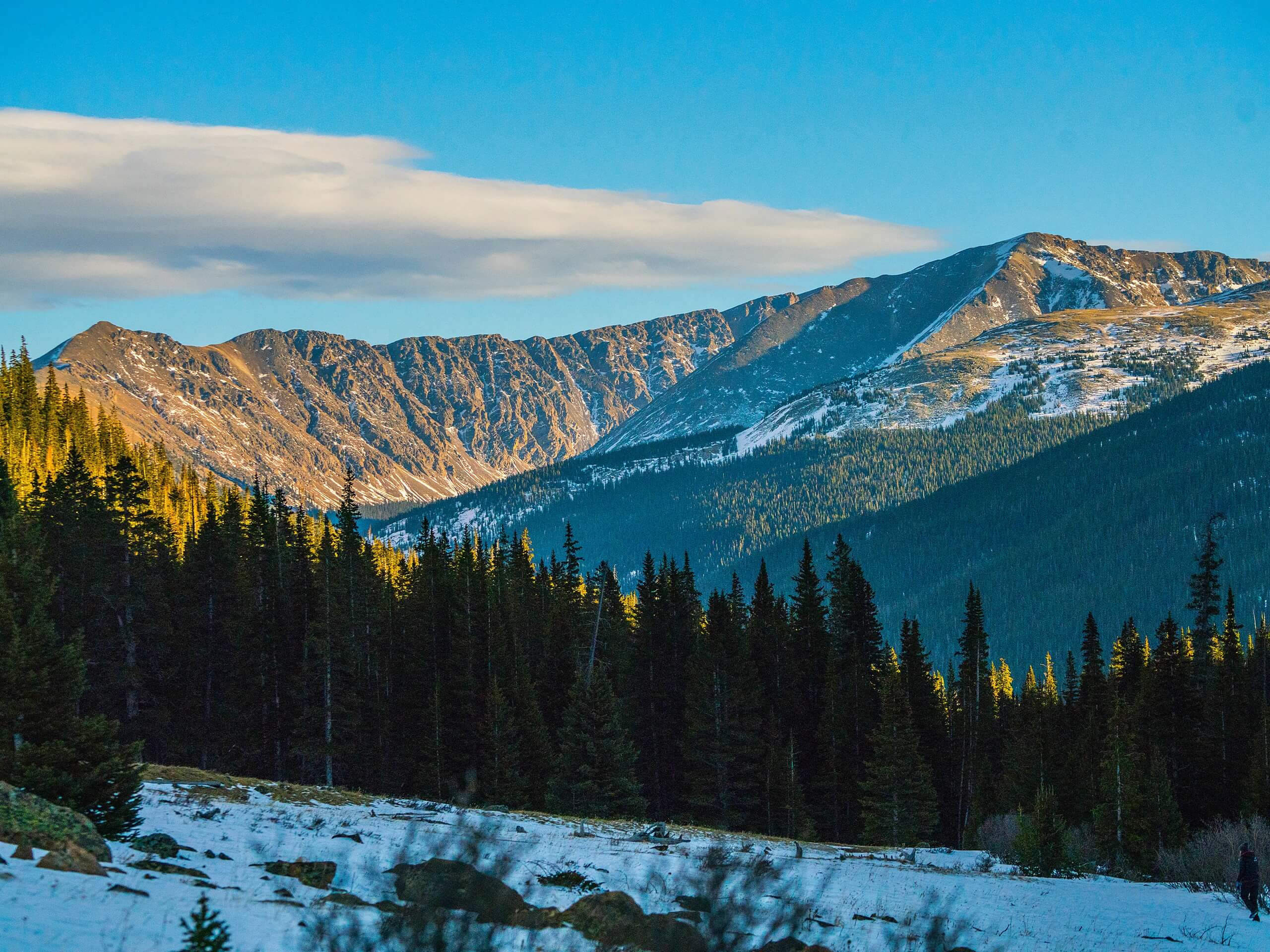
Herman Gulch Trail
Difficulty Rating:
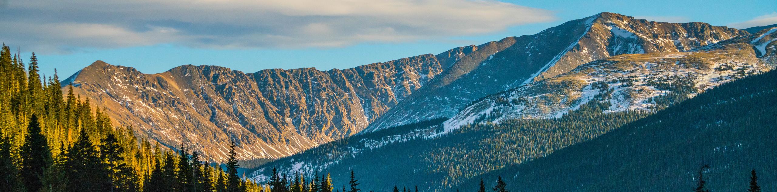
Hike up the Continental Divide to a picturesque alpine lake. The Herman Gulch Trail is a wonderful day hike in the Arapaho National Forest. Hike one of the most panoramic routes in the Front Range. The trail is a section of the much longer, Continental Divide National Scenic Trail, if you are feeling adventurous, continue hiking one of the connecting routes!
Getting there
The Herman Gulch Trailhead is off of Route I-70 on the Frontage Road.

About
| Backcountry Campground | Dispersed Camping Permitted, check rules and regulations. |
| When to do | Year-round |
| Pets allowed | Yes - On Leash |
| Family friendly | Older Children only |
| Route Signage | Average |
| Crowd Levels | High |
| Route Type | Out and back |
Herman Gulch Trail
Elevation Graph
Weather
Herman Gulch Hike Description
The Herman Gulch Trail is like no other. Hike up a forested creek valley to unobstructed views of a crystal-clear lake flanked by the Continental Divide. Hiking the Herman Gulch Trail is no walk in the park, make sure to wear sturdy footwear and bring plenty of water to stay hydrated at the high altitude. Though this trail is marked as family-friendly, it is worth noting that the initial and rearmost sections of the trail are steep, and the entirety of the hike has a gradual climb. The hike is manageable for older children, especially if there are snack stops along the way. Make sure to wear layers as the last few kilometers of the trail and the lake are exposed to the elements. Expect windier conditions and make sure to check for storms before departing on this adventure.
One of our favorite things about the Herman Gulch Trail is that it is a year-round adventure. We love hiking this path in the summer months but if you don’t mind the cold you can head up the valley in the winter alike. If you choose to venture the Herman Gulch Trail in the winter months, make sure you are wearing snowshoes and bring trekking poles. Few adventurers also try to cross country ski up this climbing route. Whether you visit in the winter or the summer months, this trail offers scenic vistas along the path and expansive views of surrounding Colorado mountains from the lake.
Begin your adventure up the Herman Gulch Trail from the parking lot. Note that there are washroom facilities near the trailhead. When you are ready, track northeast on the Herman Gulch Trail. Hike the path and you will quickly meet a junction. At this intersection, veer left, diverting northwest up the path. Trek along the Herman Gulch Trail as it guides you under tree coverage. The valley will begin to widen, and the terrain will become more gradual as you continue hiking. Soon the trail will meet up with the Herman Creek.
Follow along the route as it hugs the curves of the Herman Creek and weaves you between open subalpine meadows and dense woodlands. Continue hiking the valley trail nestled between Mount Bethel in the west and Mount Machebeuf in the east. Maintain along the path, noticing vibrant wildflowers that dot the route in the warmer months.
As you travel up the path, the trail will eventually diverge from the Herman Creek and guide you above the treeline. Once you ascend the timberline, follow the rock cairns to the lake. At this point, you will encounter another intersection. Here, stay left, and head west along the Herman Gulch Trail. This section of the trail is becoming increasingly steep and rocky as you ascend the exposed alpine tundra path to Herman Lake. Keep an eye out for mountain goats and bighorn sheep in this area.
Climb up the route and Herman Lake awaits you. Explore the lake’s shore and bask in the beautiful scenery that surrounds you. Get an up close and personal view of The Citadel in the southwest and Pettingell Peak towering above on the Continental Divide. Herman Lake is a great place to relax and dip your tired feet in the water. Enjoy the stunning vistas of the Colorado mountainous landscape and forested valleys below.
Rest and refuel before beginning your descent. When you are ready to return, simply retrace your steps all the way back to the parking lot.
Trail Highlights
Pettingell Peak
Pettingell Peak is one of Colorado’s 13ers. Sitting at an elevation of 13553ft, the Pettingell Peak sits near the end of the Colorado’s 13ers rank. Though it might not be the highest mountain, the Pettingell Peak is scenic and isolated. Hike up the Continental Divide and summit the scenic peak that flanks Herman Lake. Only 45 minutes from Denver the Pettingell Peak Hike is a perfect spontaneous excursion out of the city. Hike along the busy Herman Gulch Trail until you summit the lake, then you will probably have the path all to yourself. The east side of the mountain is craggy and attracts adventurers who love to scramble up technical terrain. Scramble over the rocky ridge and up a talus to Pettingell Peak’s summit. Enjoy sights of the Loveland Ski area below and The Citadel peak in the south.
Frequently Asked Questions
Can I swim in Herman Lake?
Yes, you can swim in Herman Lake. But be warned, it is very cold.
Is Herman Gulch Trail open year-round?
Yes, the Herman Gulch Trail is open year-round. Trade your hiking boots for snowshoes in the winter months.
Similar hikes to the Herman Gulch Trail hike

Hankins Pass Hike
The Hankins Pass Hike is a quintessential adventure across the Lost Creek Wilderness. The hike demonstrates the diversity of the…

Miller Gulch Loop Trail
The Miller Gulch Loop Trail is a scenic meadowland adventure in the Pike National Forest. Hike through grassy meadows laden…

The Castle Hike
The Castle Hike is an exciting adventure up the steep, forested terrain to The Castle Rock. From atop the summit,…
Comments