Greyrock Trail
View Photos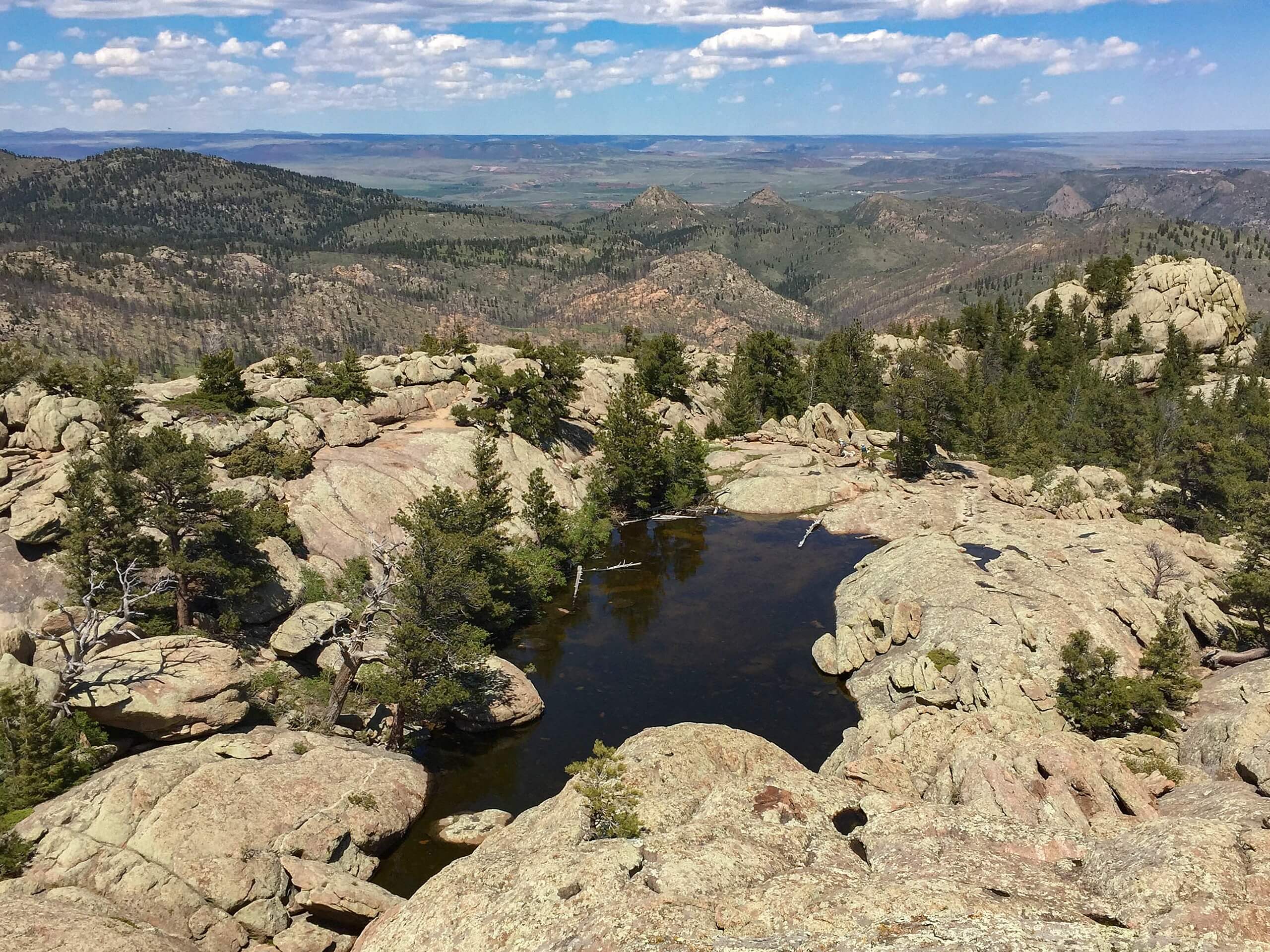
Greyrock Trail
Difficulty Rating:
Greyrock Trail lives up to its name. This trail will give you sights of the rocky summit from the plains, and vistas of the Rocky Mountains and river valleys from the summit. This trail is one of our favorites in the area. Share the meadow-cloaked trail with Colorado wildlife, and enjoy the fresh mountain air as you summit the rocky mountain that showcases the quintessential Colorado landscapes. You’ve got to add this excursion to your adventure bucket list.
Getting there
The Greyrock Trailhead is off of Highway 14. Find the parking lot on the south side of the highway.

About
| Backcountry Campground | Dispersed Backcountry Camping, see rules and regulations. |
| When to do | April-November |
| Pets allowed | Yes - On Leash |
| Family friendly | Older Children only |
| Route Signage | Average |
| Crowd Levels | High |
| Route Type | Lollipop |
Greyrock Trail
Elevation Graph
Weather
Greyrock Trail Description
Hike the Greyrock Trail up to the pile of granite rocks that structure Greyrock Mountain. This hike will surely get your blood pumping as you traverse the alpine tundra and ascend the craggy peak. This trail is not overly demanding, but we would be lying if we said it wasn’t challenging. Most skill levels should be able to manage this popular Northern Colorado trail. Ensure to pack plenty of water as there are limited water sources along the trail. Additionally, the steep rocky ascent to the peak demands sturdy footwear and careful footing. Mind gaps in the rock to avoid getting your feet wedged between the large boulders. Note this trail is mostly exposed to the elements, wear sunscreen on sunny days and be prepared for inclement and windy weather as you hike.
There is no wonder why this trail is so popular. The Greyrock Trail features all the best environments that the Colorado wilderness has to offer. Hike through aspen forests, through an alpine meadow and up to a stunning overlook. Though we consider this trail family-friendly, note there are more technical segments towards the mountain’s ridge that require careful navigation. As you travel along the scenic path notice the wildflowers that dot the plains and the picturesque craggy peaks in the backdrop.
Begin your adventure along the Greyrock Trail from the Greyrock parking lot. From the carpark, go north across Highway 14 and over the foot bridge that crosses Cache La Poudre River. Hike along the Greyrock Summit Trail as it curves west into the woods. Soon after your departure from the trailhead, you will meet an intersection. Here you can go either way to complete the circuit, but we recommend going clockwise. Veer left onto the Greyrock Meadow Trail.
Hike along the trail as it opens up to a verdant Colorado plain. Keep your eye out for moose, bears, and bobcats as you cross the meadow. Travel the scenic path and notice the impressive Greyrock Mountain in the northeast and expansive views of the Rocky Mountains in the west. Maintain along the sagebrush and mountain mahogany meadow as it gradually climbs towards Greyrock Mountain. The path will guide you back between lush aspen trees as you begin your ascent to the base of the mountain.
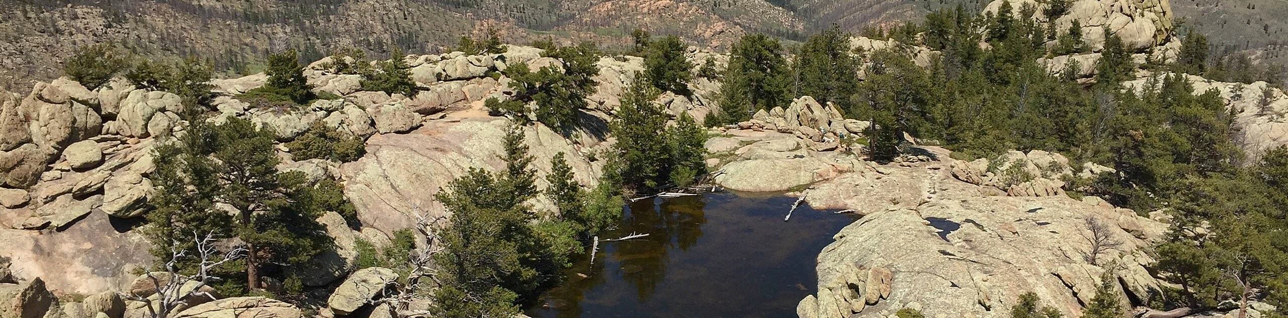
At this point, you will confront another junction. Stay left as the trail diverts you up to the summit. Exercise caution as you navigate the rocky terrain to the peak. Hike along the trail as it guides you north along the mountain ridge before curving south up to the summit. Enjoy the smooth granite rocks dotted with aspens and an alpine pond at the top. Explore the impressive mountain top and enjoy panoramic views of the Colorado landscape below.
Notice Milton Seaman Reservoir and the scenic Cache La Poudre River in the east, and revel in the sights of craggy, snow-dusted Colorado Ranges and rolling aspen forests that surround you. After enjoying the scenery at the summit, head back down the ridge the way you came. At the junction, stay left this time to loop back on the Greyrock Summit Trail. Follow the new path as you descend the rocky terrain into the woodlands.
Hike through the aspen forest down into a valley. Follow the path through the gulch until you meet another intersection. Here, turn left and head east down the path. This route will lead you back to the Cache La Poudre River and over the highway and back to the parking lot.
Trail Highlights
Cache La Poudre River
Cache La Poudre River is a popular tourist attraction in the Front Range. Cache La Poudre river is so named because in the early 1800’s during a severe blizzard, French-Canadian trappers and hunters hid their gunpowder here to weather the storm. Cache La Poudre River has carved out an impressive river valley over the years that has earned itself the title as Colorado’s only, and nationally designated “Wild and Scenic River”. This river begins in the craggy peaks of the Rocky Mountain National Park and runs all the way to Fort Collins. This impressive river is a popular white water rafting, canoeing and fishing destination.
Insider Hints
Pack some provisions for the day and enjoy a picnic atop Greyrock Mountain
Due to the abundance of wildlife in the area, consider wearing a bear bell to deter any unwelcome encounters
If you have a permit, consider camping along the trail or at one of the designated campsites along Cache La Poudre River.
Similar hikes to the Greyrock Trail hike

Hankins Pass Hike
The Hankins Pass Hike is a quintessential adventure across the Lost Creek Wilderness. The hike demonstrates the diversity of the…

Miller Gulch Loop Trail
The Miller Gulch Loop Trail is a scenic meadowland adventure in the Pike National Forest. Hike through grassy meadows laden…

The Castle Hike
The Castle Hike is an exciting adventure up the steep, forested terrain to The Castle Rock. From atop the summit,…
Comments