
Ginny and D.R Trail
View Photos
Ginny and D.R Trail
Difficulty Rating:
The Ginny and D.R Hike is an exciting adventure through the Bobcat Ridge Natural Area. Living up to its name, don’t be surprised if you see a bobcat or mountain lion as you traverse this trail. The dry climate is inviting these and many other types of Colorado wildlife.
Getting there
The Ginny and D.R Trail is accessed via County Road 32C.

About
| Backcountry Campground | No |
| When to do | April-September |
| Pets allowed | No |
| Family friendly | Older Children only |
| Route Signage | Average |
| Crowd Levels | Moderate |
| Route Type | Lollipop |
Ginny and D.R Trail
Elevation Graph
Weather
Ginny and D.R Hike Description
The Ginny and D.R Hike is a desert-like adventure. Travel through sagebrush abundant plains, past large granite outcroppings, over streams and through sparse pine coverage. This trail is a popular mountain biking destination, so expect to share the trail with fellow adventurers. The Ginny and D.R Trail is entirely exposed, meaning it is also incredibly scenic. Enjoy vistas of the encompassing Front Range peaks for as far as the eye can see. Located near Fort Collins, this excursion is the perfect escape into the wilderness. Be wary of wildlife. If you see a bear or mountain lion, be sure to give them ample space and be mindful of rattlesnakes.
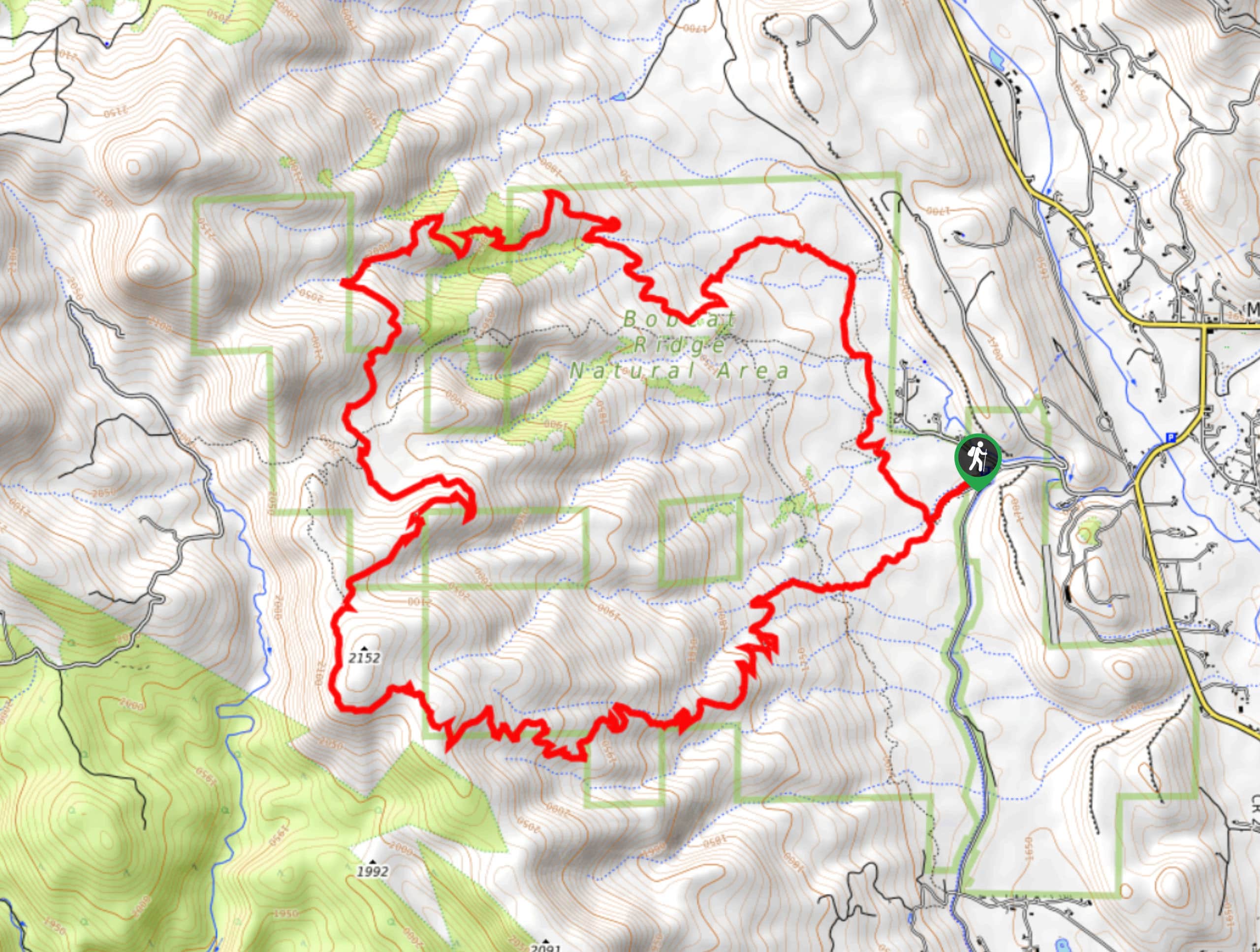
The Ginny and D.R Trail is a circuit hike; thus, it can be completed in either direction. We will let you decide, but we suggest tracking clockwise. Begin your adventure from the parking lot and trailhead. Take the leftmost route along the Valley Loop Trail. The initial segment of the trail is steep, but don’t let that discourage you, it will eventually plateau in a scenic field. Soon, you will confront an intersection, stay straight and you will be diverted onto the Ginny Trail. Ascend the trail and navigate the switchbacks. Cross the several stream intersections and the path will eventually plateau.
Hike around the large granite outcroppings as the route curves you north. Continue along the Ginny Trail until it merges into the D.R Trail. Descend the D.R Trail and trek the exposed path as it curves east. Hike down under sparse tree coverage as you navigate several more stream crossings. Soon, you will encounter the D.R Trail’s end and you will be led back onto the Valley Loop Trail. Hike the Valley Loop Trail back to the parking lot.
Similar hikes to the Ginny and D.R Trail hike

Hankins Pass Hike
The Hankins Pass Hike is a quintessential adventure across the Lost Creek Wilderness. The hike demonstrates the diversity of the…

Miller Gulch Loop Trail
The Miller Gulch Loop Trail is a scenic meadowland adventure in the Pike National Forest. Hike through grassy meadows laden…

The Castle Hike
The Castle Hike is an exciting adventure up the steep, forested terrain to The Castle Rock. From atop the summit,…
Comments