
Emmaline Lake Trail
View Photos
Emmaline Lake Trail
Difficulty Rating:
The Emmaline Lake Trail has it all. A forested path, babbling streams, waterfalls, a lake, lush meadows, wildlife and mountain views. What more could you ask for? This stunning trail is lengthy, but do not worry, there are seven designated backcountry campsites for you to set up shop and spend the night. This unforgettable trail is a must-add to your Colorado adventure list.
Getting there
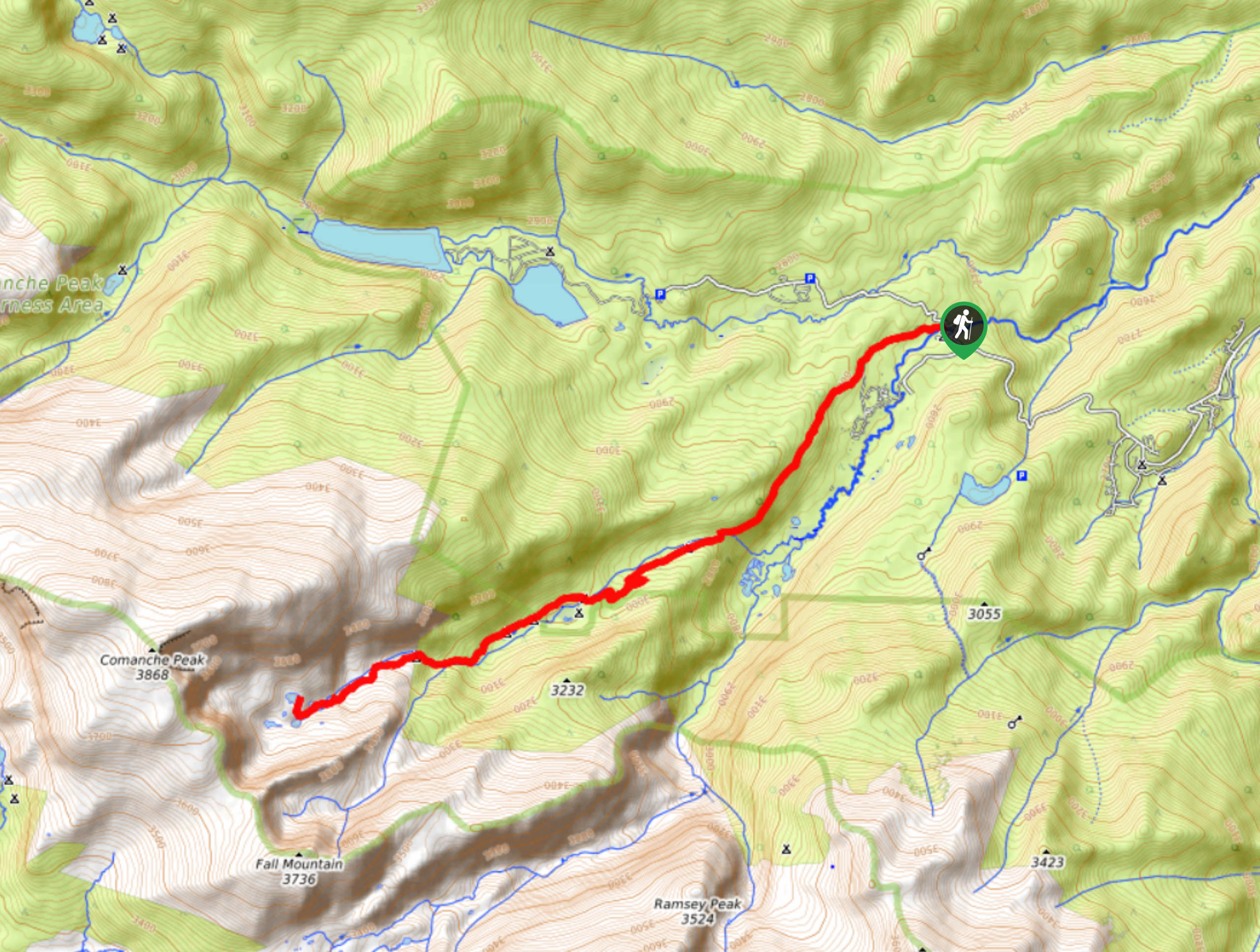
The Emmaline Lake Trailhead is located off Forest Development Road 145 at the end of FDR200, an old dirt road.

About
| Backcountry Campground | Yes, at designated campsites along the trail |
| When to do | June-September |
| Pets allowed | Yes - On Leash |
| Family friendly | Older Children only |
| Route Signage | Average |
| Crowd Levels | Moderate |
| Route Type | Out and back |
Emmaline Lake Trail
Elevation Graph
Weather
Emmaline Lake Hike Description
The Emmaline Lake Hike is a picturesque nature trail. This path is stunning, especially in the fall when the aspens turn bright yellow. This adventure is one of our favorites, but it does require a bit of planning. This excursion is lengthy, so if you are going to walk it as a day-hike, we suggest heading out early. Hiking in the summer requires no special equipment, but if you are to hike the Emmaline Lake Trail in the autumn or winter, consider wearing microspikes and bringing trekking poles to help navigate snowy or icy conditions. This trail is an awesome adventure, but it might not be suitable for kids. Older children should be able to manage the terrain, but bear in mind it exceeds 12.4mi there and back. Pack plenty of snacks to refuel and lots of water!
Embark on your adventure to Emmaline Lake from the trailhead. Track southwest on the Emmaline Lake Trail. Shortly after your departure there will be two intersecting paths, maintain on Emmaline Lake Trail. Notice Colorado State University’s Mountain Campus in the east. Continue hiking along the forested route as it follows the Cache La Poudre River. You will eventually diverge away from the river and intersect with Fall Creek before encountering a junction. Here, stay straight on the Emmaline Lake Trail. At this point, you will intersect with the creek again and meet several of the backcountry campsites at Cirque Meadow.
Hike up the trail, gradually gaining elevation as you reenter the woodlands and meet a waterfall. Nearing the lake, there are also more campsites around the small waterfall. Hike up the final segment of the trail to Emmaline Lake. Climb up the increasingly rocky terrain as you crest Emmaline Lake. Revel in the beauty of the crystalline alpine lake hemmed by the craggy Comanche Peak, this sight is truly unforgettable. Take your time and admire the stunning scenery before commencing your return. To get back to the car, simply retrace your steps back along the route to the trailhead.
Similar hikes to the Emmaline Lake Trail hike

Hankins Pass Hike
The Hankins Pass Hike is a quintessential adventure across the Lost Creek Wilderness. The hike demonstrates the diversity of the…

Miller Gulch Loop Trail
The Miller Gulch Loop Trail is a scenic meadowland adventure in the Pike National Forest. Hike through grassy meadows laden…

The Castle Hike
The Castle Hike is an exciting adventure up the steep, forested terrain to The Castle Rock. From atop the summit,…
Comments