
Bard Creek Trail
View Photos
Bard Creek Trail
Difficulty Rating:
The Bard Creek Trail is a popular backpacking adventure through the Arapaho National Forest, but it’s an even better one-way day hike in our opinion! We love adventures that exhibit various terrains and the Bard Creek Trail delivers just that! Explore the new scenery every step of the way!
Getting there
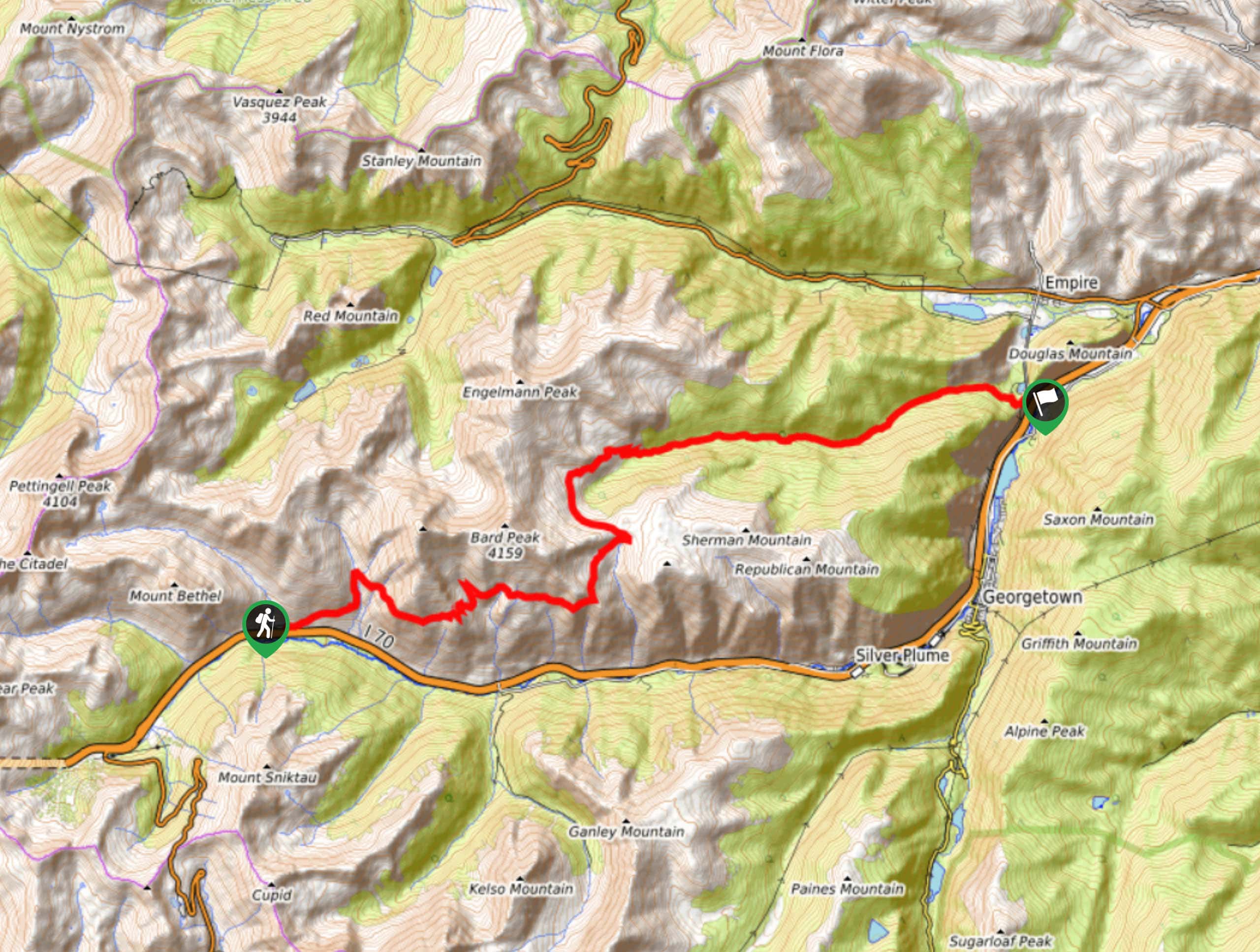
The Bard Creek Trail departs from the Herman Gulch Trailhead and finishes at the end of County Road 232.

About
| Backcountry Campground | Dispersed Backcountry Camping, restrictions apply. |
| When to do | May-October |
| Pets allowed | Yes - On Leash |
| Family friendly | No |
| Route Signage | Average |
| Crowd Levels | Low |
| Route Type | One Way |
Bard Creek Trail
Elevation Graph
Weather
Bard Creek Hike Description
The Bard Creek Hike is a wonderful adventure through the mountain valleys in the Arapaho National Forest. Hike through aspen groves, alongside alpine creeks, through meadowlands and across rocky ridges. This excursion demands an intrepid spirit, hike through the various landscapes and through unmarked terrain. We recommend using the trail GPS to mitigate the chances of getting lost. Proper footwear and microspikes in the autumn and winter months are also suggested! Make sure you pack plenty of provisions and water to keep you energized as you trek this lengthy route. Don’t forget to leave a car or arrange pickup at the trail’s end!
Explore the new scenery every step of the way along the Bard Creek Trail. Begin your adventure from the Herman Gulch Trailhead. Briefly track along the Herman Gulch Trail before merging onto the Watrous Gulch Trail. Hike along the Watrous Gulch Creek up the forested valley until you meet an intersection. At this point, veer right and you will be diverted onto the Bard Creek Trail. Trek this route along the exposed ridges of Mount Parnassus and Bard Peak. Eventually, you will summit Silver Plume Mountain. Enjoy the overlook of the encompassing Front Range peaks before continuing along the Bard Creek Trail.
Eventually the Bard Creek Trail will guide you below the timberline and through aspen groves. Descend the route and it will merge onto the Bard Creek Road before delivering you to the trail’s end.
Similar hikes to the Bard Creek Trail hike

Hankins Pass Hike
The Hankins Pass Hike is a quintessential adventure across the Lost Creek Wilderness. The hike demonstrates the diversity of the…

Miller Gulch Loop Trail
The Miller Gulch Loop Trail is a scenic meadowland adventure in the Pike National Forest. Hike through grassy meadows laden…

The Castle Hike
The Castle Hike is an exciting adventure up the steep, forested terrain to The Castle Rock. From atop the summit,…
Comments