Mount Lincoln Trail
View Photos
Mount Lincoln Trail
Difficulty Rating:
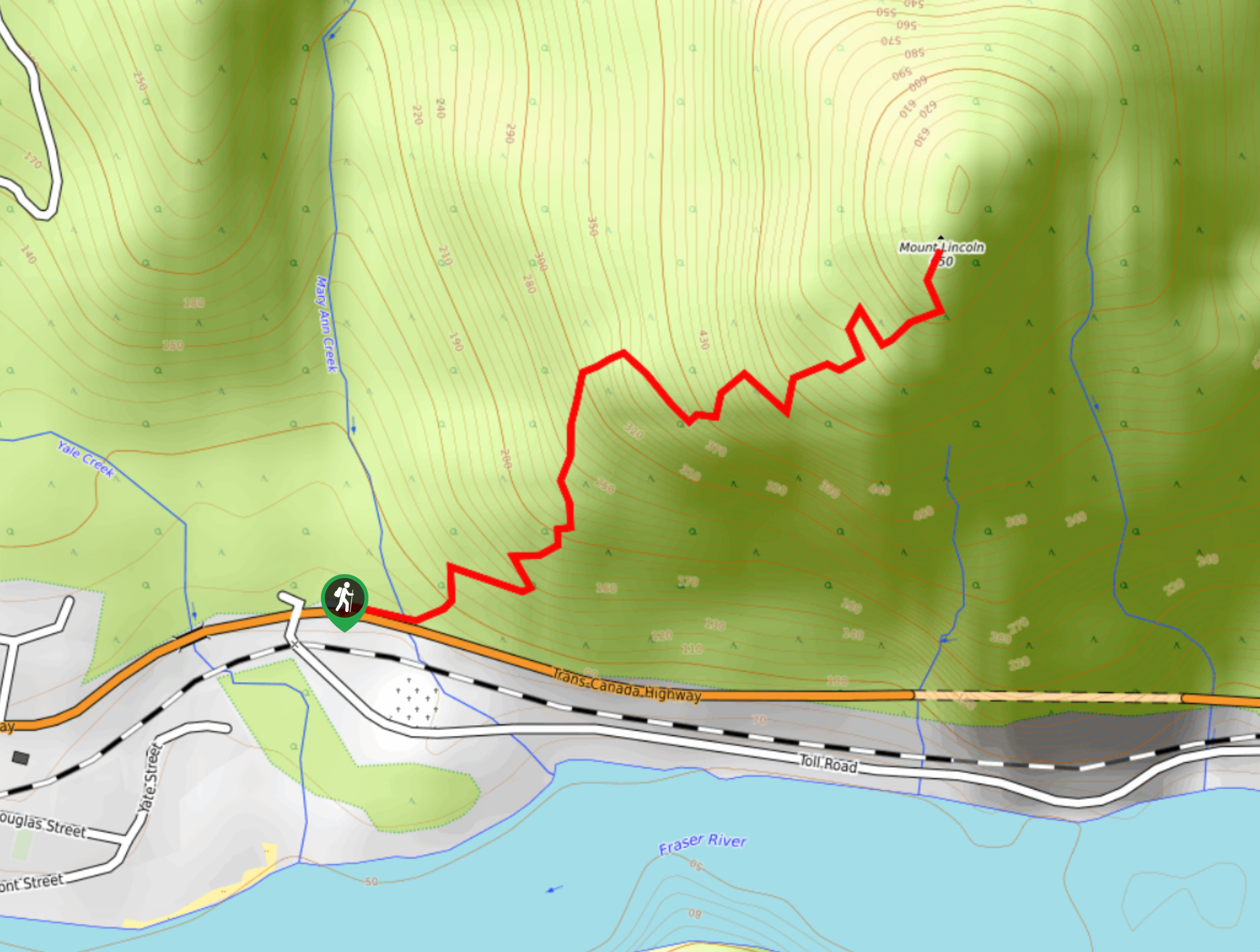
Hike along the Mount Lincoln Trail to experience beautiful views over the Fraser Valley on this short, adventurous route. Located just north of Hope, BC in the town of Yale, Mount Lincoln is a rugged peak that overlooks the coursing waters of the Fraser River. Along this trail you can expect a steep climb to the summit with several rope sections to help with your ascent.
Getting there
To reach the Mount Lincoln trailhead from Hope, drive north on BC-1 for 14.9mi, where you will find the trail on the left side of the highway.

About
| When to do | April-October |
| Backcountry Campsites | No |
| Pets allowed | No |
| Family friendly | No |
| Route Signage | Average |
| Crowd Levels | Moderate |
| Route Type | Out and back |
Mount Lincoln Trail
Elevation Graph
Weather
Mount Lincoln Trail Description
The Mount Lincoln Trail is a moderate hiking route north of Hope, BC that climbs up this steep and rugged peak to reveal scenic views of the valley and the Fraser River. At only 1.5mi, this is a short hike to the summit; however, the 1791ft of elevation gain along the route packs a real punch.
As you climb uphill, you will come across a few short scrambles, as well as some roped sections to aid in your climb. Of the three roped sections, the last is the most intimidating. Take your time. Once you reach the summit of Mount Lincoln, you will have spectacular views of the surrounding area and ample room to explore the peak in search of the perfect viewpoint. This trail is ideal for a quick and fun outdoor excursion in the Fraser Valley.
Similar hikes to the Mount Lincoln Trail hike

Chipmunk Creek Trail
Hike along the Chipmunk Creek Trail to experience the feeling of solitude along the trail while taking in scenic views…

Matsqui Trail
The Matsqui Trail is a 16.7mi multi-use trail that travels alongside the Fraser River and provides nice views…

Flora Peak Trail
The Flora Peak Trail is an 7.1mi out-and-back hiking route that will take you through dense forests and…
Comments