McKee Peak Trail
View Photos
McKee Peak Trail
Difficulty Rating:
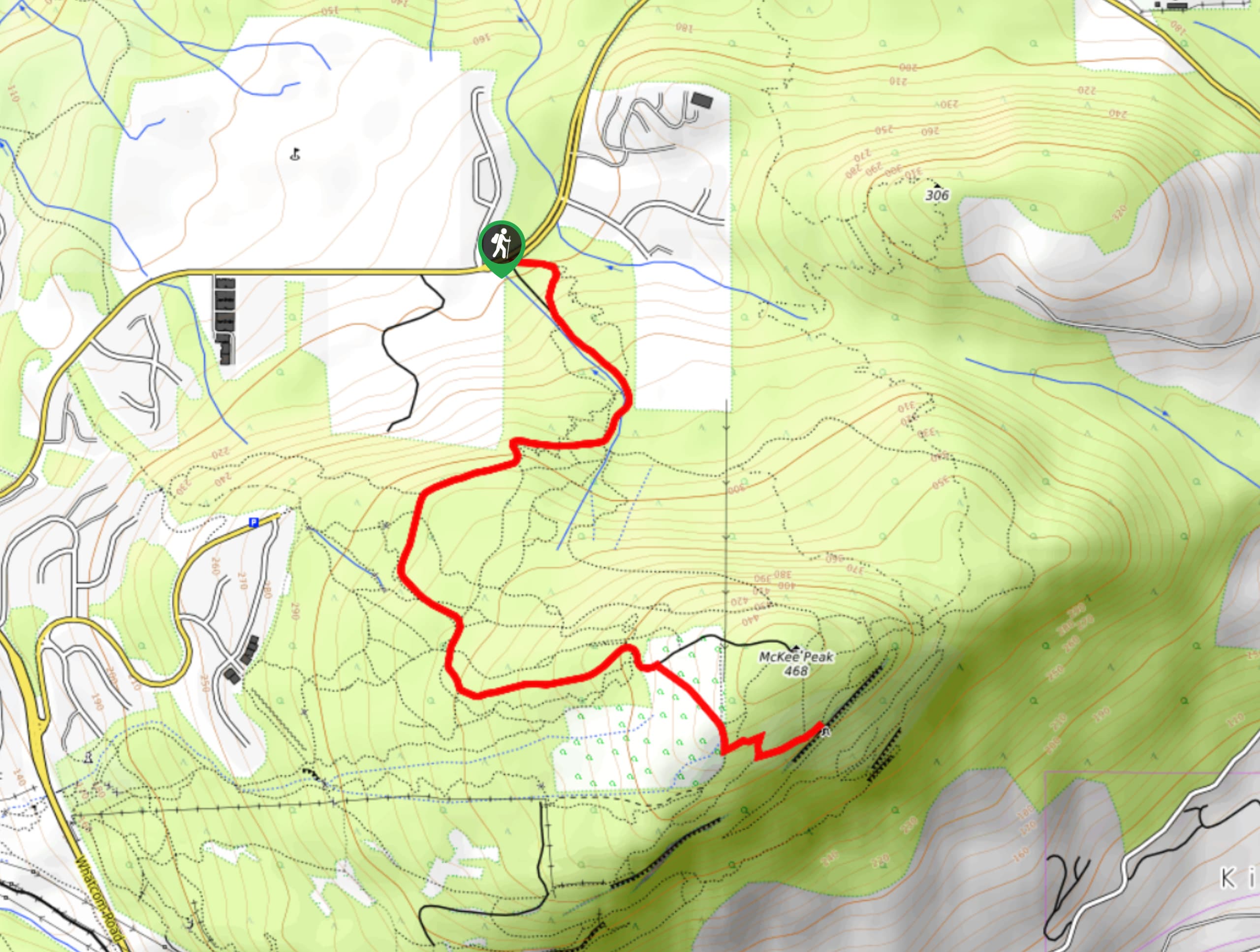
The McKee Peak Trail is a moderate hike that climbs uphill through a dense network of hiking and mountain bike trails to reach the summit of McKee Peak. This largely forested trail travels along a road, making it accessible for hikers of most skill levels. From atop the peak you will have scenic views of the surrounding area.
Getting there
To reach the parking area for the McKee Peak Trail from Abbotsford, head east on George Ferguson Way and turn left onto Ash Street. After 1312ft, the road will veer right onto Old Clayburn Road. Follow this for 1.4mi and turn right onto McKee Drive. After 820ft, turn left onto McKee Road and follow it for 1.4mi to find the parking lot on your right.

About
| When to do | Year-round |
| Backcountry Campsites | No |
| Pets allowed | Yes - On Leash |
| Family friendly | Older Children only |
| Route Signage | Average |
| Crowd Levels | Moderate |
| Route Type | Out and back |
McKee Peak Trail
Elevation Graph
Weather
McKee Peak Trail Description
The McKee Peak Trail is a popular hiking route just east of Abbotsford, BC that passes through a dense network of trails to reach the summit of McKee Peak. Hiking along this route will provide you with the option of traversing the old road leading up the mountain or utilizing the smaller side trails that travel parallel to it. It should be noted that these side trails are often travelled by mountain bikers, so keep an eye out and share the path with anyone attempting to pass by.
From the summit, you will be able to take in some scenic views of the valley from a cleared field, as well as a viewpoint that can be found just beyond the trail. This is a great hike for casual or beginner hikers.
Other Amazing Hikes in Fraser Valley
Check out our guides to Lindeman Lake, Bridal Veil Falls, Cascade Falls, Elk Mountain Trail or Hicks Lake Hike. Or see all our hikes in Fraser Valley on 10Adventures.
Similar hikes to the McKee Peak Trail hike

Chipmunk Creek Trail
Hike along the Chipmunk Creek Trail to experience the feeling of solitude along the trail while taking in scenic views…

Matsqui Trail
The Matsqui Trail is a 16.7mi multi-use trail that travels alongside the Fraser River and provides nice views…

Flora Peak Trail
The Flora Peak Trail is an 7.1mi out-and-back hiking route that will take you through dense forests and…
Comments