
Abby Grind Trail
View Photos
Abby Grind Trail
Difficulty Rating:
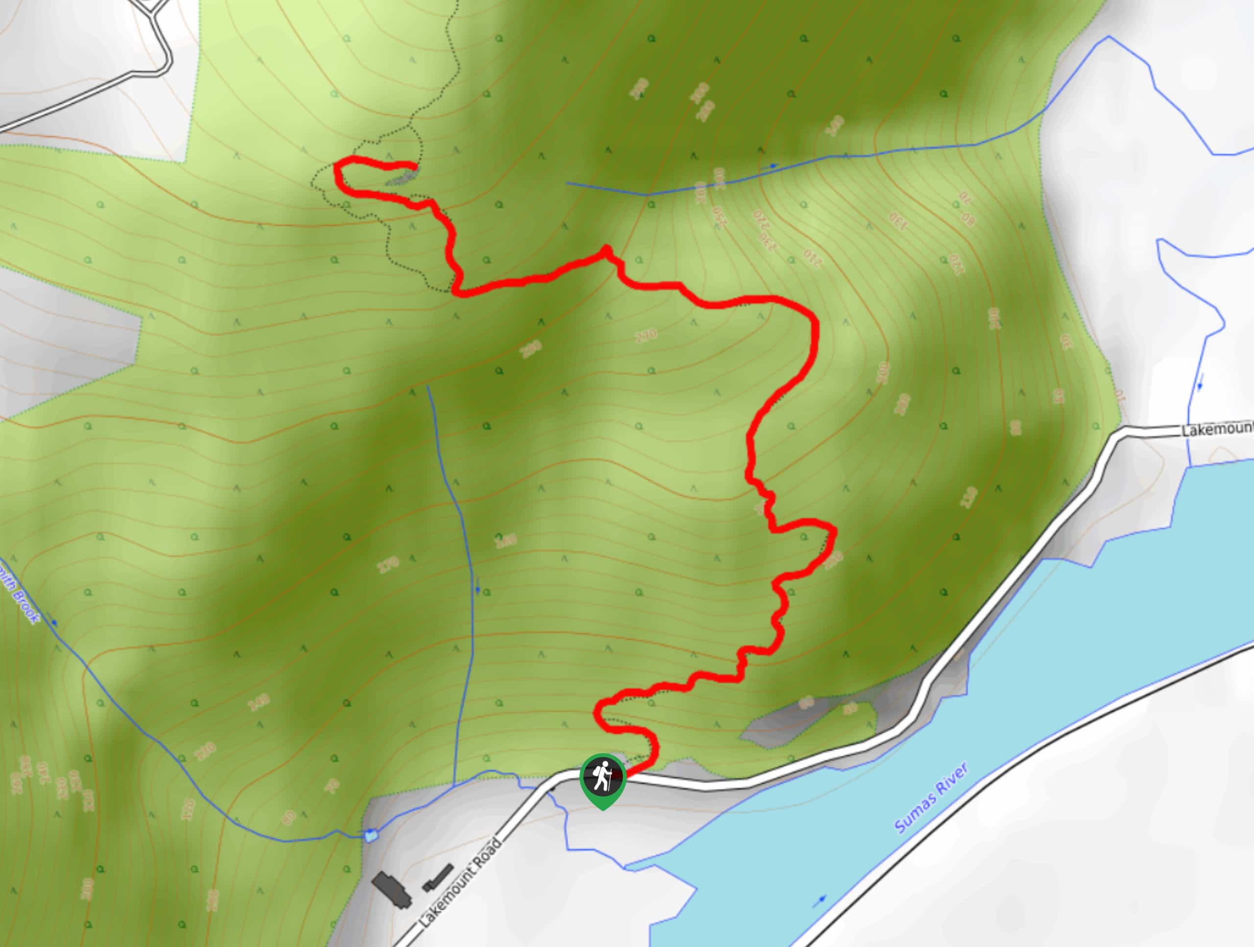
The Abby Grind Trail is an out-and-back hiking route that climbs a sharp 1391ft over a short distance of 2.1mi. While not as difficult as its Vancouver cousin the Grouse Grind, this trail is definitely a great workout on the more challenging side of moderate. From the top of the trail you’ll be able to look out over the Fraser Valley and spot the many mountain peaks that frame the landscape.
Getting there
To reach the parking area for the Abby Grind Trail from Chilliwack, head southwest on BC-1 W and take exit 104. Follow the road for 1476ft and make a slight right onto No. 3 Road before immediately turning left onto N Parallel Road. Continue on for 1.5mi and turn right onto No.4 Road, following it for 0.6mi. Turn right onto McDermott Road and the trailhead will be on the left in 2625ft.

About
| When to do | May-October |
| Backcountry Campsites | No |
| Pets allowed | Yes - On Leash |
| Family friendly | No |
| Route Signage | Average |
| Crowd Levels | High |
| Route Type | Out and back |
Abby Grind Trail
Elevation Graph
Weather
Abby Grind Trail Description
The Abby Grind Trail is a short, steep route near Abbotsford that packs 1391ft of elevation gain into a short 2.1mi trail. Due to the steep nature of the hike, it’s best to wear good hiking boots or trail runners and bring hiking poles to lessen the impact on your knees. While we recommend leaving this hike for a dry day, make sure to bring microspikes in wet weather, as the trail can become very slippery. This trail is a popular spot with both hikers and workout enthusiasts, so make sure to arrive early to get a parking spot next to the trailhead. There is a gun range near the trailhead, so you may hear intermittent gunshots near the beginning of the hike- don’t panic!
As mentioned, this route climbs steeply uphill over a short distance, providing a good workout without being too drawn-out. The trail itself is largely composed of packed dirt with little in the way of rocks or roots, making it safe and easy to navigate. In addition to having sweeping views over the Fraser Valley, you will also be able to spot a number of nearby mountain peaks including the Bald, Black, Slide, and Red mountains.
Setting out on the trail, follow it into the dense tree cover as you immediately begin climbing. The trail has a peaceful woodland setting, a perfect distraction from the incline. Continue to climb uphill as the trail weaves through the forest, offering glimpses of the valley as you push on. Eventually the path will turn west on the final push up to the top of the trail.
From the lookout atop the Abby Grind Trail, you will be able to catch your breath and take in the spectacular views of the surrounding area. Looking out across the green expanse of the Fraser Valley, you will be able to see a long line of rugged peaks including Old Baldy, Vedder Mountain, Lincoln Peak, and the Bald, Black, Slide, and Red mountains. After taking in the views and resting for a bit, make your way back down the Abby Grind Trail to return to your vehicle. Take care descending steeper sections.
Other Amazing Hikes in Fraser Valley
Check out our guides to Lindeman Lake, Bridal Veil Falls, Cascade Falls, Elk Mountain Trail or Hicks Lake Hike. Or see all our hikes in Fraser Valley on 10Adventures.
Insider Hints
Arrive early as this trail can become very busy.
Bring water to stay hydrated on this intense route.
Wear good hiking boots or trail runners for the best footing on the steep incline.
Poles are very helpful for this hike.
Similar hikes to the Abby Grind Trail hike

Chipmunk Creek Trail
Hike along the Chipmunk Creek Trail to experience the feeling of solitude along the trail while taking in scenic views…

Matsqui Trail
The Matsqui Trail is a 16.7mi multi-use trail that travels alongside the Fraser River and provides nice views…

Flora Peak Trail
The Flora Peak Trail is an 7.1mi out-and-back hiking route that will take you through dense forests and…
Comments