
Kelly Canyon Trail
View Photos
Kelly Canyon Trail
Difficulty Rating:
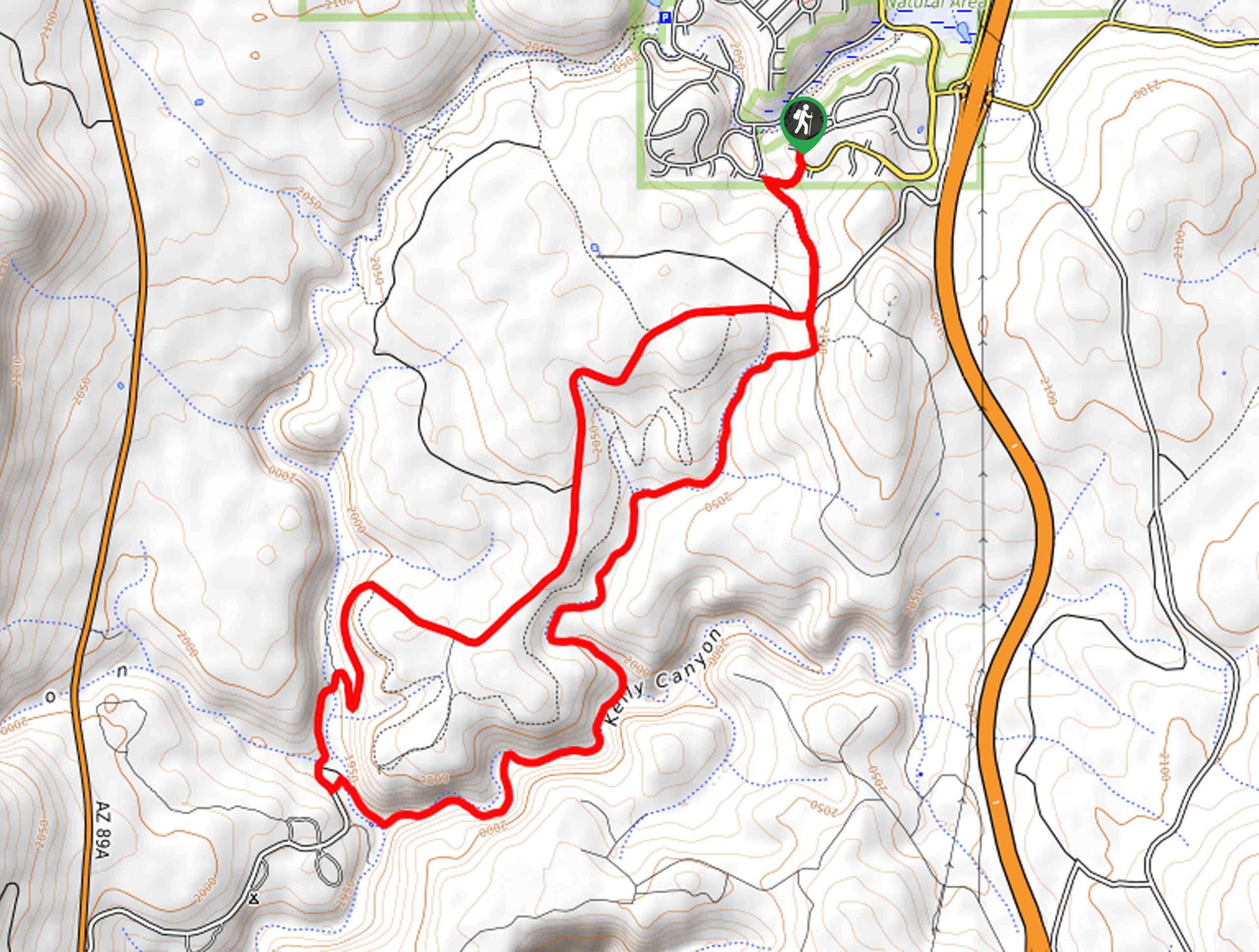
The Kelly Canyon Trail is a scenic 17.5mi hike that leads you down through Kelly Canyon just south of Kachina Village. This is a good choice for both hikers and mountain bikers. There’s lots of shade on this route for hot days, but on the flip side, it’s not the best choice in the winter because of how icy the trail can get. Expect moderate traffic.
Getting there
The trailhead for Kelly Canyon Trail is on Toho Trail.

About
| Backcountry Campground | No |
| When to do | April-October |
| Pets allowed | Yes - On Leash |
| Family friendly | Yes |
| Route Signage | Average |
| Crowd Levels | Moderate |
| Route Type | Loop |
Kelly Canyon Trail
Elevation Graph
Weather
Kelly Canyon Trail Description
The Kelly Canyon Trail meanders through its namesake canyon just south of Kachina Village, Arizona. This route offers beauty in the smaller details: geodes, caves, mushrooms, moss, and wildlife. We love it on a hot summer day when the shade of the trees is just right. You can use this route for hiking and biking.
This trail isn’t a good pick before April or after October as it can get very icy, especially since there’s so much shade. If you choose to come in the winter, we recommend bringing microspikes to make the trip easier.
From the trailhead, head down towards the wash. The trail splits at the forest road and Kelly Pocket Trail. We definitely recommend going to Kelly Pocket first, as some hikers prefer this as an out-and-back to skip the forest road altogether. Stay left and hike down into the canyon. The route follows the curvature of the canyon until you reach Pumphouse Wash. From here, it climbs the canyon wall on the forest road and returns to the loop split via the road.
Similar hikes to the Kelly Canyon Trail hike

Fay Canyon Loop
Fay Canyon is one of several main canyons in the Walnut Canyon National Monument. This loop hike explores part of…

Sandy Steps, Heart, and Upper Oldham Trail
The Sandy Steps, Heart, and Upper Oldham hike makes use of several different trails to create a hike that stretches…

Fisher Point via Fay Canyon
Fisher Point is one of the best viewpoints into the gorgeous Walnut Canyon. This route leads you to the point…
Comments