
Dewerstone Walk
View Photos
Dewerstone Walk
Difficulty Rating:
The Dewerstone Walk is a quick and rugged adventure in Dartmoor National Park that will see you climb uphill along overgrown paths for spectacular views of the surrounding landscape. While out on the trail, you will walk along the banks of the River Plym and pass by imposing slabs of rock set in a beautifully atmospheric stretch of forest on the way to the summit of the hill. If you are interested in rock climbing, the rocky, craggy terrain that can be found here offers over 100 different routes that service all skill levels.
Getting there
To reach the trailhead for the Dewerstone Walk from the roundabout in Roborough, head northeast for 450ft and turn right onto New Road, following it for 1.4mi. Make a left here and continue on for 1.7mi, where you will find the car park on the left.

About
| When to do | March-October |
| Backcountry Campsites | No |
| Pets allowed | Yes - On Leash |
| Family friendly | Yes |
| Route Signage | Average |
| Crowd Levels | Moderate |
| Route Type | Lollipop |
Dewerstone Walk
Elevation Graph
Weather
Dewerstone Walk Description
Although the Dewerstone Walk is only a short route, it does feature some rugged terrain and stretches of trail that are overgrown with vegetation. Be sure to wear proper walking boots for the best footing while out on this trail. Additionally, various wildlife species, such as birds of prey and a number of squirrels, inhabit the area. Remember to pack out any trash that you may bring/create to keep this area as pristine as possible.
Even though this route is a bit overgrown, it is still a fantastic adventure that will produce beautiful views overlooking the forests and rugged terrain of Dartmoor National Park. Because of the rocky terrain and various crags that can be found here, this area is a popular spot for rock climbers, so keep an eye out and you might get to spot them in action. Whether you are after a quick walk up the hillside or an adventurous day of climbing some challenging routes, the Dewerstone Walk is a fantastic way to get out and explore the outdoors.
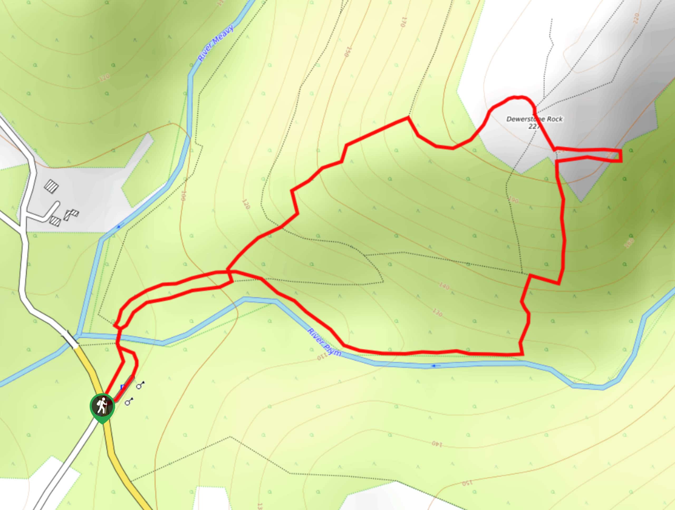
Setting out from the car park, follow the trail north and cross over the River Plym to arrive at a junction. Head to the right and continue on through the wonderfully atmospheric forest setting of Dewerstone Wood, as you climb uphill through the rough terrain with giant slabs of rock looming overhead. Upon reaching the summit, you will be greeted with beautiful views overlooking the forest and surrounding landscape of Dartmoor National Park. After taking in the views, make your way south to descend the rocky hillside towards the banks of the River Plym. Here, you will turn to the west and walk alongside the river, once again crossing over the bridge to return to the car park having completed the Dewerstone Walk.
Trail Highlights
Dewerstone
Local folklore has it that the Dewerstone – ‘Dewer’ meaning devil in Celtic – is the location where the devil rides across the moor on a black horse with a pack of phantom hounds, chasing humans over the rocky outcrop to fall to their deaths. In terms of historical significance, the Dewerstone was once the site of an Iron Age hillfort, remnants of which can be seen today. The hill is also a popular rock climbing destination, with over 100 different routes along its rocky surface.
Insider Hints
Wear proper walking boots with good ankle support, as portions of this walk are very uneven underfoot.
Arrive early to secure parking, particularly during summer.
Similar hikes to the Dewerstone Walk hike

Shipley Bridge and Avon Dam Reservoir Walk
Located in the southern part of Dartmoor National Park, the Shipley Bridge and Avon Dam Reservoir Walk is a lovely…

The Sherlock Holmes Track
The Sherlock Holmes Track is a fun adventure in the southeast corner of Dartmoor National Park that will take you…

Ryder’s Hill via Sandy Way Trail
The Ryder’s Hill via Sandy Way Trail is a beautiful walking route in Dartmoor National Park that will lead you…
Comments